KETCHIKAN GATEWAY BOROUGH PLANNING COMMISSION ...
KETCHIKAN GATEWAY BOROUGH PLANNING COMMISSION ...
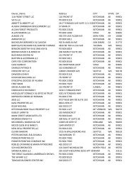
KETCHIKAN GATEWAY BOROUGH PLANNING COMMISSION ...

You also want an ePaper? Increase the reach of your titles
YUMPU automatically turns print PDFs into web optimized ePapers that Google loves.
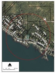
17.20.040 PLATTING PROCEDURES AND REQUIREMENTS – FINAL PLATb. Number of lots, tracts or parcels of ground to be created.(3) A north arrow and the scale of the drawing shall be shown on the plat.(4) A vicinity map, no less than four (4) inches by four (4) inches in size, shall be located in the upper rightcorner of the first sheet of the final plat, drawn at a scale of no greater than one (1) inch equals one (1)mile, showing the proposed subdivision in relation to existing physical features, landmarks and sectionlines. The vicinity map shall show the township, range and section number where the proposed subdivisionis located.(c)Survey Data.(1) Boundaries of the tract shall be fully balanced and closed to an accuracy of at least third order, showingall bearings and distances, determined by an accurate survey in the field, all dimensions expressed in feetand decimals thereof.(2) The plat shall indicate that all exterior corners of the subdivision are permanently monumented with abrass or aluminum cap set in concrete in the ground or affixed to an iron rod not less than five-eighths(5/8) inch in diameter or an iron pipe not less than one (1) inch in diameter, driven to refusal or a minimumpenetration of three (3) feet in solid ground. The plat shall indicate that all lot corners have been monumentedwith an iron rod not less than five-eighths (5/8) inch in diameter which has been permanentlyidentified with the surveyor’s license number, driven to refusal or a minimum penetration of three (3) feetin solid ground.(3) The final plat shall show the bearings and distances of all lot lines, boundary lines, easement lines, rightof-waylines, centerlines of existing and proposed easements and existing and proposed rights-of-way.The plat shall show the lengths, tangents and dimensions of areas dedicated to public streets, rights-ofway,easements, and other public reservations and the width of all easements, rights-of-way, and streetseach way from the centerline. The basis of bearings shall be shown with a tie (bearing and distance) to amonument shown on the plat. All dimensions and distances shall be expressed in feet and decimalsthereof to the nearest one hundredth (1/100) of a foot. Easement boundaries shall be shown by brokenlines.(4) Location and description of all physical encroachments upon the boundaries of the tract.(d)Descriptive Data.(1) Names, right-of-way lines, courses, lengths, and widths of all public or private streets, alleys, crosswalksand utility easements; radii, points of tangency and central angles of all curvilinear streets and alleys; radiiof all rounded street line intersections; and designation of whether such streets or other matters are to beprivate or dedicated to the public.(2) All drainageways designated as such and dedicated to the public.(3) All utility and public service easements including water, sewer, power, telephone and drainage showingany limitations of easements and whether dedicated to the public.(4) Location and all dimensions of all lots.(5) All lots shall be numbered consecutively throughout the plat; exceptions for tracts and private parks shallbe so designated and dimensioned and identified by letter or number.(6) Location, dimensions, bearings, radii, arcs and central angles of all sites to be dedicated to the public andsuch designation specified.(7) Location and names of adjacent subdivisions and the owners of adjoining parcels of unsubdivided land.17-28