- Page 1 and 2: Version 2.1EnglishLeica TPS700 Seri
- Page 3 and 4: View of chaptersPoint Numbers and P
- Page 5 and 6: Applications 46Introduction 46Surve
- Page 7 and 8: Point Numbers and Point SearchIncre
- Page 9 and 10: Point search is always startedwith
- Page 11 and 12: EDM SettingsThe EDM settings contai
- Page 13 and 14: Prism typeOpen the function in the
- Page 15 and 16: Leica Geosystems PrismsConstants[mm
- Page 17 and 18: OffThe automatic Guide Light EGL is
- Page 19 and 20: Refraction correctionThe refraction
- Page 21 and 22: FunctionalityThe built-in Automatic
- Page 23 and 24: Automatic Reflector SearchIf the re
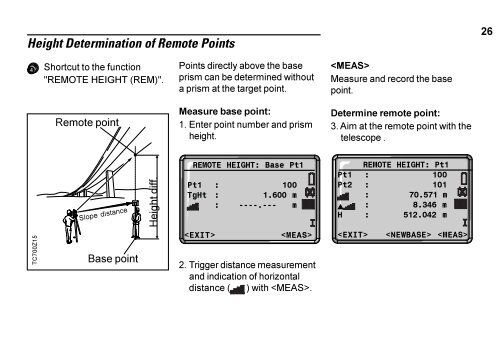
- Page 25: Change EDMDirect call up of the "Ch
- Page 29 and 30: TrackingShortcut to the function "T
- Page 31 and 32: Delete Last RecordShortcut to the f
- Page 33 and 34: REC (Storing)Actual measured data i
- Page 35 and 36: Error messages:"SET A JOB FIRST""NO
- Page 37 and 38: All subsequent recordeddata is stor
- Page 39 and 40: Set ManuallyIf an entered point num
- Page 41 and 42: OrientationThis program enables ano
- Page 43 and 44: ORI(max.5Pt): 1/ 1/3BsPt : 201BsBrg
- Page 45 and 46: Useful Information• If the orient
- Page 47 and 48: The following programs areavailable
- Page 49 and 50: Measuring display 1Measuring displa
- Page 51 and 52: The final computed results areEasti
- Page 53 and 54: Computation ProcedureThe computatio
- Page 55 and 56: FREE STATION 0/ 2/2PtID : ABC1Hz :
- Page 57 and 58: 2nd page:Displays standarddeviation
- Page 59 and 60: Error MessagesMessagesMeaningSelect
- Page 61 and 62: Setting OutSetting Out Coordinates
- Page 63 and 64: Polar SetoutNormal indication of po
- Page 65 and 66: 2. starts the point search andfinds
- Page 67 and 68: 1. Polygonal Methods (A-B, B-C)TC70
- Page 69 and 70: 2. Radial Methods (A-B, A-C)TC700Z1
- Page 71 and 72: Reference LineThis program facilita
- Page 73 and 74: Reference LineThe base line can be
- Page 75 and 76: Triggers a distancemeasurement.Meas
- Page 77 and 78:
Offset input:INPUT LINE&OFFSETPtID
- Page 79 and 80:
Sets of Angles MeasurementsIntroduc
- Page 81 and 82:
Selecting Sets of Angles functionsT
- Page 83 and 84:
If the set limit isexceeded during
- Page 85 and 86:
Define target listIn this part of t
- Page 87 and 88:
The measurement display is setup as
- Page 89 and 90:
Switching functions onand off (e.g.
- Page 91 and 92:
Start with setIn the first line the
- Page 93 and 94:
Calculating the Hz-directionsThe fo
- Page 95 and 96:
Examples and formulas usedPt#/Statu
- Page 97 and 98:
Average error of a direction measur
- Page 99 and 100:
a = A direction averaged and measur
- Page 101 and 102:
TC700Z34Polygonal length, fromstart
- Page 103 and 104:
ResultsAREA RESULTNoPts : 15Area :
- Page 105 and 106:
Procedure1. Open the start dialog.S
- Page 107 and 108:
Further displaysChange to further d
- Page 109 and 110:
Preparing a code listWith the compu
- Page 111 and 112:
Code List SelectionAll codes in the
- Page 113 and 114:
Error messagesMessagesAttrib. canno
- Page 115 and 116:
Quick CodeUsing the quick code func
- Page 117 and 118:
Menu+SYSTEM MENUDATA MANAGER1 Meas/
- Page 119 and 120:
Data ManagerThe Data Manager contai
- Page 121 and 122:
If "A*" is entered, all data forwhi
- Page 123 and 124:
JobJobs are a summary of data ofdif
- Page 125 and 126:
Delete MemoryIndividual jobs or com
- Page 127 and 128:
Data DownloadWith this special func
- Page 129 and 130:
Messages and WarningsMessagesData S
- Page 131 and 132:
Quick Settings"Quick Settings" are
- Page 133 and 134:
BeepThe beep sounds after each keyp
- Page 135 and 136:
USER-KeyAllocation of a function fr
- Page 137 and 138:
DSP-HeaterOnIs automatically activa
- Page 139 and 140:
Slope%--.--%71°34'45°+300%+100%Th
- Page 141 and 142:
UnitsMEASUREMENT UNITSAngle : 400go
- Page 143 and 144:
Interface plug connections:5 41 321
- Page 145 and 146:
Buttons:Measurements are triggerede
- Page 147 and 148:
Determining The Line-Of-Sight Error
- Page 149 and 150:
4. Change telescope position andaim
- Page 151 and 152:
After the first measurement iscompl
- Page 153 and 154:
Possible Messages when Determining
- Page 155 and 156:
System-InfoUseful information which
- Page 157 and 158:
Saving DataThe following categories
- Page 159 and 160:
NoPts = Number of targetpoints used
- Page 161 and 162:
Area ApplicationMeasurement (1):PtN
- Page 163 and 164:
Orientation results:PtID(1) = Point
- Page 165 and 166:
Sets Hz ResultsActive Sets = Number
- Page 167 and 168:
Sets Dist ResidualsPtID = Point IDS
- Page 169 and 170:
Fixed Points (Coordinates)RS232GSI-
- Page 171 and 172:
DData .............................
- Page 173 and 174:
MManual code input ................
- Page 175 and 176:
TTarget Offset ....................