0 - FTP Directory Listing - Nato
0 - FTP Directory Listing - Nato
0 - FTP Directory Listing - Nato
You also want an ePaper? Increase the reach of your titles
YUMPU automatically turns print PDFs into web optimized ePapers that Google loves.
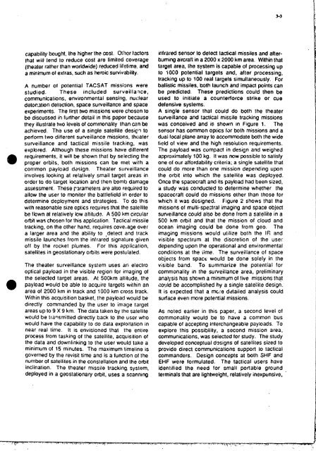
capability bought, the higher the cost. OEIior factors<br />
that will tend to reduce cost are limited coverage<br />
(theater rathQr than workhide) reduced lifotima, and<br />
a minimum of extras, such as heroic survivability.<br />
A number 01 potential TACSAT missions were<br />
studied. These in c I u d e d sur ve i I I a 'ice,<br />
communicalions, environmental sensing, nuclear<br />
detomtbn detection, space surveillame and space<br />
experiments. The first two missions were chosen lo<br />
be discussed in furlher detail in this paper because<br />
they illustrate two levels of commonality than can bg<br />
achieved. Tho use of a single satellite desip to<br />
perform two diflerent surveillance missions, thtiater<br />
surveillance and tactical missile tracking, was<br />
explored. Although these missions have different<br />
requirements, it will be shown that by selecting the<br />
@ proper orbits, both missions can be met with a<br />
conimon payload dasign. Theater surveillance<br />
involves looking at relatively small target areas in<br />
order to do target location and then bomb damage<br />
assessment. These rarameters are also required to<br />
allow the user to monitor the battlefield in order to<br />
determine deployment and strategies. To do this<br />
with reasonable size optics requires that tho satellite<br />
be flown at relatively low altitude. A 500 hm circular<br />
orbii was chosen lor this applicalion. Tactical missile<br />
tracking, on the other hand, requires cove# age over<br />
a larger area and the ability to ,detect and track<br />
missile launches from the infrared signature given<br />
off by the rocket plumes. For this application,<br />
satellites in geostationary orbits were postulated.<br />
The theater surveillance system uses an electro<br />
optical payload in the visible region lor imaging of<br />
the selected target areas. At 500km altitude, the<br />
payload would be able to acquire targets within an<br />
area of 2900 km in track and 1000 km cross track.<br />
Within this acquisition basket, the payload would be<br />
directly commanded by the user to image target<br />
areas up to 9 X 9 km. The data taken by the satellite<br />
would be trarlsmitted directly back to the user who<br />
would have the capability to do data exploitation in<br />
near real time. It is envisioned that the entire<br />
process from tasking of the satellite, acquisition of<br />
the data and downlinking to the user would take a<br />
minimum of 15 minutes. The maximum timeline is<br />
governed by the revisit time and is a function of the<br />
number of satellites in the constellation and tho orbit<br />
inclination. The theater missile tracking, system,<br />
deployed in a geostationary orbit, uses a scanning<br />
infrared sensor 00 dePm tadical missiles and after-<br />
burning aircraW in a 2000 x 2000 km area. Within that<br />
target area, iRe system is capable of processing up<br />
to TOO0 potential targets and, after processing,<br />
tracking up to 100 real targets simultaneously. For<br />
ballistic missiles, b lh launch and impact points can<br />
be predicted. These predictions could then be<br />
used to initiate a counterlorce strike or cue<br />
defensive systems.<br />
A single sensor that could do both the theater<br />
surveillance and tactical missile tracking missions<br />
was conceived and is shown in Figure 1. The<br />
sensor has common opiics far both missions and a<br />
*ai focal plane array to accommodate both the wide<br />
field of view and the high resoiution requirements.<br />
The payload was compact in design and weighed<br />
approximately 100 kg. It was now possible to satisfy<br />
one of our aftordability criteria; a single satellite that<br />
could do more than one mission depending upon<br />
the orbit into which the satellite was deployed.<br />
Once the spacecraft and its payload had been sized,<br />
a study was conducted lo determine whether the<br />
spacecraft could do missions other than those for<br />
which it was designed. Figure 2 shows that the<br />
missions of multi-spectral imaging and space object<br />
surveillance could also be done from a satellite in a<br />
500 km orbit and that the mission of cloud and<br />
ocean imaging could be done from geo. The<br />
imaging missions would ulilize both the IE and<br />
visible spectrum at the discretion of the use!'<br />
depending upon the operational and environmental<br />
conditions at the iime. The surveillance of space<br />
objects from spacc would be done solely in the<br />
visible band. To summarize the potential for<br />
commonality in the surveillance area, preliminary<br />
analysis has shown a minimum of five missions that<br />
corJld be accomplished hy a single satellite design.<br />
It is expected that a mwe ddtailed analysis could<br />
sudace even more potential missions.<br />
As noted earlier in lhis paper, a second level of<br />
commonality would be to have a common bus<br />
capable of accepting interchangeable payloads. To<br />
explore lhis possibility, a second mission area,<br />
communications, was selected for study. The study<br />
developed conceptual d3signs of satellites sized to<br />
provide direct communications support to tactical<br />
commanders. Design concepts at both SHF and<br />
EHF were formulated. The tactical users have<br />
idenlilied the need for small portable ground<br />
terminals that are lightweight, relatively inexpensive,<br />
3-3


