Eurobodalla Integrated Water Cycle Management Strategy
Eurobodalla Integrated Water Cycle Management Strategy
Eurobodalla Integrated Water Cycle Management Strategy

Create successful ePaper yourself
Turn your PDF publications into a flip-book with our unique Google optimized e-Paper software.
152<br />
<strong>Eurobodalla</strong> <strong>Integrated</strong> <strong>Water</strong> <strong>Cycle</strong> <strong>Management</strong> <strong>Strategy</strong><br />
Existing <strong>Water</strong> <strong>Management</strong> System<br />
The area is supplied by the regional water supply scheme, which fills three local service<br />
reservoirs, Tomakin Heights for the small number of houses in Barlings Drive, Burri Point<br />
Reservoir for Rosedale, Guerilla Bay and Tomakin, and Mossy Point for the Mossy Point<br />
and Broulee areas. The Tomakin Heights reservoirs have a combined capacity of 0.2 ML.<br />
The capacity of Mossy Point reservoirs is 4.6 ML and Burri Point is 5.0 ML. Current and<br />
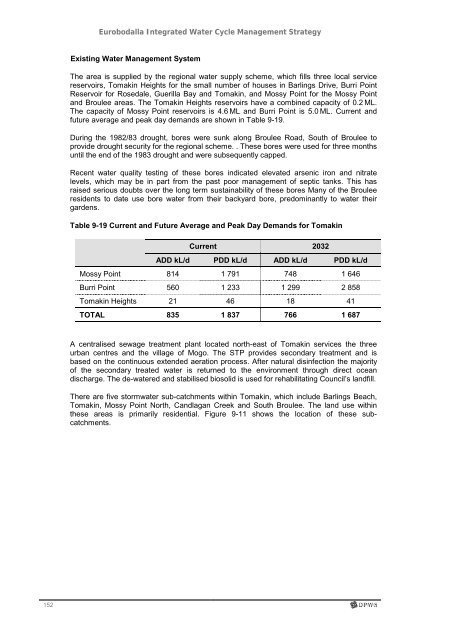
future average and peak day demands are shown in Table 9-19.<br />
During the 1982/83 drought, bores were sunk along Broulee Road, South of Broulee to<br />
provide drought security for the regional scheme. . These bores were used for three months<br />
until the end of the 1983 drought and were subsequently capped.<br />
Recent water quality testing of these bores indicated elevated arsenic iron and nitrate<br />
levels, which may be in part from the past poor management of septic tanks. This has<br />
raised serious doubts over the long term sustainability of these bores Many of the Broulee<br />
residents to date use bore water from their backyard bore, predominantly to water their<br />
gardens.<br />
Table 9-19 Current and Future Average and Peak Day Demands for Tomakin<br />
Current 2032<br />
ADD kL/d PDD kL/d ADD kL/d PDD kL/d<br />
Mossy Point 814 1 791 748 1 646<br />
Burri Point 560 1 233 1 299 2 858<br />
Tomakin Heights 21 46 18 41<br />
TOTAL 835 1 837 766 1 687<br />
A centralised sewage treatment plant located north-east of Tomakin services the three<br />
urban centres and the village of Mogo. The STP provides secondary treatment and is<br />
based on the continuous extended aeration process. After natural disinfection the majority<br />
of the secondary treated water is returned to the environment through direct ocean<br />
discharge. The de-watered and stabilised biosolid is used for rehabilitating Council’s landfill.<br />
There are five stormwater sub-catchments within Tomakin, which include Barlings Beach,<br />
Tomakin, Mossy Point North, Candlagan Creek and South Broulee. The land use within<br />
these areas is primarily residential. Figure 9-11 shows the location of these subcatchments.