- Page 1 and 2:
The Fen Management Handbook Edited
- Page 3 and 4:
Acknowledgements Production of the
- Page 5 and 6:
1. Introduction and Basic Principle
- Page 7 and 8:
Estimates of the original coverage
- Page 9 and 10:
Guiding principles for fen manageme
- Page 11 and 12:
Section 12: Fens from an Economic P
- Page 13 and 14:
2.1 Diversity and conservation sign
- Page 15 and 16:
Part of Cropple How Mire in Cumbria
- Page 17 and 18:
The moss flora of base-rich springs
- Page 19 and 20:
Bog bean growing in a transitional
- Page 21 and 22: Mesotrophic openwater transition fe
- Page 23 and 24: Water shrews (Neomys fodiens), also
- Page 25 and 26: 2.4.1 Vegetated margins of open wat
- Page 27 and 28: 2.4.3 Grazed or cut fen in floodpla
- Page 29 and 30: 2.6 Amphibians Amphibians are depen
- Page 31 and 32: The mud snail Omphiscola glabra (12
- Page 33 and 34: Old trees and dead wood Continuous
- Page 35 and 36: Vascular plants Flat-sedge Blysmus
- Page 37 and 38: 3. Understanding Fen Hydrology Quan
- Page 39 and 40: Groundwater discharge to fens is us
- Page 41 and 42: Water Table 3.4.1.4 Spring fed fen
- Page 43 and 44: 3.5 Factors determining fen type 3.
- Page 45 and 46: - Flooding - frequency and magnitud
- Page 47 and 48: 3.7 Further information and advice
- Page 49 and 50: Groundwater inflow. Groundwater lev
- Page 51 and 52: It is likely that groundwater disch
- Page 53 and 54: Case Study 3.3 Hydro(geo)logical im
- Page 55 and 56: 4. Understanding Fen Nutrients Nutr
- Page 57 and 58: nutrients. For example, at high con
- Page 59 and 60: 4.2.1 Groundwater and surface water
- Page 61 and 62: 4.2.3 Point and diffuse sources of
- Page 63 and 64: Area of acute nutrient enrichment o
- Page 65 and 66: 4.4 Classifying water chemistry usi
- Page 67 and 68: 4.6 Identifying nutrient enrichment
- Page 69 and 70: Negative indicator species for diff
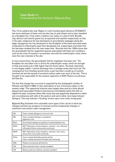
- Page 71: Many of the floristic changes which
- Page 75 and 76: 5.1 Why do fens need management? In
- Page 77 and 78: 5.2 Checklist of key stages in deci
- Page 79 and 80: 5.3.3 Scale Although fens are linke
- Page 81 and 82: 5.4 Site survey to establish what i
- Page 83 and 84: variability and how these relate to
- Page 85 and 86: - The fauna which inhabit the fen c
- Page 87 and 88: - Prioritise objectives to achieve
- Page 89 and 90: inundation are less likely to be sp
- Page 91 and 92: 5.13 References Barsoum, N., Anders
- Page 93 and 94: Case Study 5.2 Fen Management and R
- Page 95 and 96: - 14km of livestock fencing install
- Page 97 and 98: Case Study 5.3 Fen Management and R
- Page 99 and 100: 6. Fen Management and Restoration -
- Page 101 and 102: Both the benefits and potentially l
- Page 103 and 104: Cattle forced by flooding to the ed
- Page 105 and 106: At low/medium stocking density, cat
- Page 107 and 108: Goats have narrow muzzles and a fle
- Page 109 and 110: Fens usually feature a range of dif
- Page 111 and 112: Excessive poaching where cattle hav
- Page 113 and 114: extensive areas of wetlands which w
- Page 115 and 116: ‘Soft track’ machines, such as
- Page 117 and 118: The design of the pipeline allows f
- Page 119 and 120: Protocol for burning standing reedb
- Page 121 and 122: Long rotation scrub clearance may b
- Page 123 and 124:
‘Bird-eye’ and incineration A t
- Page 125 and 126:
6.7 Restoring fen meadow Many forme
- Page 127 and 128:
Current Management The current mana
- Page 129 and 130:
Case Study 6.2 Fen Vegetation Manag
- Page 131 and 132:
species diversity of wetland passer
- Page 133 and 134:
The temptation to burn large areas
- Page 135 and 136:
Outcomes In the eight years that th
- Page 137 and 138:
Anglesey sites is now underway supp
- Page 139 and 140:
Close grazed short sward of sedges
- Page 141 and 142:
Turf cutting Turf cutting has been
- Page 143 and 144:
7.1 A framework to assist decision
- Page 145 and 146:
Surface water level change e.g. - a
- Page 147 and 148:
and the surface to acidify, resulti
- Page 149 and 150:
Smaller excavations are preferable
- Page 151 and 152:
Morton Lochs, which extend to appro
- Page 153 and 154:
Although shallow excavations are pr
- Page 155 and 156:
At Leighton Moss in Lancashire, are
- Page 157 and 158:
Excavating spoil within the area to
- Page 159 and 160:
uilt dams can only be formed in dit
- Page 161 and 162:
Case Study 7.1 Fen Water Management
- Page 163 and 164:
Case Study 7.2 Fen Water Management
- Page 165 and 166:
Case Study 7.3 Fen Water Management
- Page 167 and 168:
Case Study 7.4 Fen Water Management
- Page 169 and 170:
8. Managing Fen Nutrient Enrichment
- Page 171 and 172:
Summary table of key techniques for
- Page 173 and 174:
8.2 Managing the source of nutrient
- Page 175 and 176:
Marginal interceptor ditch at Cors
- Page 177 and 178:
8.3.4 Bund creation In some cases i
- Page 179 and 180:
emoval or soil stripping, both of w
- Page 181 and 182:
8.5 Monitoring nutrient reduction D
- Page 183 and 184:
Recent photo of stripped surface sh
- Page 185 and 186:
9.1 Scope for fen creation The Grea
- Page 187 and 188:
9.3 What type of fen? New fens can
- Page 189 and 190:
9.5 Restraints on fen creation Plan
- Page 191 and 192:
9.6 Check list of issues to conside
- Page 193 and 194:
9.7 Site assessment Planning and de
- Page 195 and 196:
LIDAR maps can provide a general un
- Page 197 and 198:
generally more acidic than silts an
- Page 199 and 200:
Site visits and careful assessment
- Page 201 and 202:
9.8.4 Plastic membranes On sites wi
- Page 203 and 204:
Use of seed bombs ‘Seed bombs’
- Page 205 and 206:
Experience has shown that the most
- Page 207 and 208:
9.10.2 Creation of niches for plant
- Page 209 and 210:
Meade, R. & Wheeler, B.D. 2007. Rai
- Page 211 and 212:
- On-going measurement of the effec
- Page 213 and 214:
with appropriate training. Providin
- Page 215 and 216:
10.3 Biological monitoring techniqu
- Page 217 and 218:
Undesirable species for key NVC com
- Page 219 and 220:
10.3.3 Vegetation Mapping An initia
- Page 221 and 222:
It is good practise to record with
- Page 223 and 224:
10.4 Biological monitoring techniqu
- Page 225 and 226:
for Ornithology, the Bat Conservati
- Page 227 and 228:
Box 2: Construction, installation a
- Page 229 and 230:
10.8 Monitoring surface water flows
- Page 231 and 232:
- Phytometric tests measure how wel
- Page 233 and 234:
Storage of data and information on
- Page 235 and 236:
period, simply because it is design
- Page 237 and 238:
Another consideration is the likely
- Page 239 and 240:
11.1 An historical perspective Poll
- Page 241 and 242:
Inviting volunteer involvement in f
- Page 243 and 244:
11.3.3 Stakeholders ‘Stakeholders
- Page 245 and 246:
have been designated under access a
- Page 247 and 248:
11.6.4 Boardwalks Boardwalks are no
- Page 249 and 250:
11.6.5 Water borne access Waterways
- Page 251 and 252:
- Explore opportunities to stimulat
- Page 253 and 254:
Case Study 11.1 Fens and people - S
- Page 255 and 256:
Case Study 11.2 Fens and People - H
- Page 257 and 258:
12. Fens from an Economic Perspecti
- Page 259 and 260:
12.1.3 Biomass energy and Biofuels
- Page 261 and 262:
12.2 Environmental regulation 12.2.
- Page 263 and 264:
the peat carbon store is depleted t
- Page 265 and 266:
Another mechanism for funding wetla
- Page 267 and 268:
Whitlaw Mosses in Scotland (see det
- Page 269 and 270:
12.8 References Dickie, I., Hughes,
- Page 271 and 272:
Nitrogen fixation conversion of gas
- Page 273 and 274:
Appendix III - List of species refe
- Page 275 and 276:
Table 1 - Mammal species associated
- Page 277 and 278:
280 Bittern Botaurus stellaris All
- Page 279 and 280:
Grasshopper Warbler 282 Locustella
- Page 281 and 282:
Table 4 - Fish species associated w
- Page 283 and 284:
Table 5 - Legally protected inverte
- Page 285 and 286:
288 Community Topogenous fens S24 P
- Page 287 and 288:
290 Community S8 Scirpus lacustris
- Page 289 and 290:
292 Community M11 Carex demissa - S
- Page 291 and 292:
294 Community M23 Juncus effusus /
- Page 293 and 294:
Appendix V - Legal and regulatory c
- Page 295 and 296:
298 Type of Works Guidance for UK C
- Page 297 and 298:
Appendix VI - Fen management for br
- Page 299 and 300:
However, three of the four species
- Page 301 and 302:
Sensitive periods Harvest mice bree
- Page 303 and 304:
species like bittern, and then drop
- Page 305 and 306:
Sensitive periods Species breed wit
- Page 307 and 308:
Great Crested Newt Great crested ne
- Page 309 and 310:
Appendix VIII - Fen management for
- Page 311 and 312:
Mollusca (snails, slugs and mussels
- Page 313 and 314:
Other than for rare or exceptional
- Page 315 and 316:
There is usually some degree of sub
- Page 317 and 318:
Management requirements for protect
- Page 319 and 320:
Appendix IX - Further reading Secti
- Page 321 and 322:
Koerselman, W., Bakker, S.A. & Blom
- Page 323 and 324:
Section 5: Fen Management and Resto
- Page 325 and 326:
Patzelt, A, Wild, U. and Jörg Pfad
- Page 327 and 328:
Index A access 103, 110, 190, 226,
- Page 329:
cutting 114 disposal 117 management