assessment of the socio-economic and environmental impact
assessment of the socio-economic and environmental impact
assessment of the socio-economic and environmental impact

You also want an ePaper? Increase the reach of your titles
YUMPU automatically turns print PDFs into web optimized ePapers that Google loves.
3. Transport, Roads <strong>and</strong> Bridges<br />
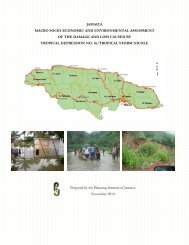
Both main roads maintained by <strong>the</strong> National Works Agency (NWA) <strong>and</strong> by Parish Councils<br />
(PCs) suffered heavy damage due to <strong>the</strong> onslaught <strong>of</strong> Hurricane Dean. As in Hurricane Ivan, <strong>the</strong><br />
road connecting Kingston <strong>and</strong> <strong>the</strong> Norman Manley International Airport was affected by storm<br />
surge causing flooding in <strong>the</strong> area <strong>of</strong> <strong>the</strong> Harbour View round-a-bout <strong>and</strong> piling s<strong>and</strong><br />
approximately1.5 meters high along <strong>the</strong> length <strong>of</strong> <strong>the</strong> road. Storm surge also caused heavy<br />
damage to <strong>the</strong> coastal roads in St. Thomas <strong>and</strong> Portl<strong>and</strong>. Some <strong>of</strong> <strong>the</strong> major arterial roads that<br />
sustained damage <strong>and</strong> blockage included <strong>the</strong> following:<br />
1. Goshen Main Road, St. Elizabeth<br />
2. The Yallahs Ford, St. Thomas<br />
3. Junction Main Road, St Mary<br />
The National Works Agency (NWA) reported that a total <strong>of</strong> 446 roadways were blocked by<br />
fallen trees, debris, washed down silt <strong>and</strong> l<strong>and</strong>slips due to <strong>the</strong> hurricane. Parishes hardest hit<br />
were Portl<strong>and</strong>, St. Thomas <strong>and</strong> St. Ca<strong>the</strong>rine with <strong>the</strong> cost to reopen <strong>and</strong> restore amounting to a<br />
high <strong>of</strong> $332.08 million in St. Thomas.<br />
The total cost to reopen NWA <strong>and</strong> PC roads was estimated at $545.97 million while <strong>the</strong> cost to<br />
restore NWA roads is set at $566.38 million. The total effect <strong>of</strong> <strong>the</strong> disaster on <strong>the</strong> road transport<br />
sector was estimated as $1.112 billion. Cost to re-open includes clearing <strong>of</strong> slips/blockages <strong>of</strong><br />
roads, temporary repairs to roads <strong>and</strong> cleaning <strong>of</strong> critical drains. Balance to complete includes<br />
restoration <strong>of</strong> asphaltic <strong>and</strong> unasphaltic roads, cleaning <strong>of</strong> blocked drains, <strong>and</strong> repair <strong>of</strong><br />
kerb/channel, relay culverts <strong>and</strong> construction/reconstruction <strong>of</strong> Retaining wall (see Table 4.4).<br />
NWA has estimated that <strong>the</strong>re will be an additional cost <strong>of</strong> $755.0 million for river training,<br />
gabion works <strong>and</strong> sea defence to correct damage in eight parishes. The cost to repair <strong>and</strong> replace<br />
retaining walls in four parishes is $160.0 million while it is estimated to cost $20.0 million to<br />
refurbish <strong>and</strong>/replace damaged traffic signals across <strong>the</strong> isl<strong>and</strong>.<br />
Twelve days after <strong>the</strong> event <strong>the</strong>re were still 47 affected intersections located in Kingston & St.<br />
Andrew, St. Ca<strong>the</strong>rine, Manchester, St. James, Clarendon <strong>and</strong> St. Elizabeth where traffic signals<br />
were non-operational. This was due to <strong>the</strong> lack <strong>of</strong> electrical supply at 30 <strong>of</strong> <strong>the</strong>se intersections,<br />
59