assessment of the socio-economic and environmental impact
assessment of the socio-economic and environmental impact
assessment of the socio-economic and environmental impact

You also want an ePaper? Increase the reach of your titles
YUMPU automatically turns print PDFs into web optimized ePapers that Google loves.
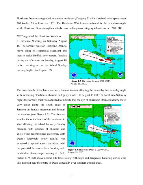
Hurricane Dean was upgraded to a major hurricane (Category 3) with sustained wind speeds near<br />
205 km/h (125 mph) on <strong>the</strong> 17 th . The Hurricane Watch was continued for <strong>the</strong> isl<strong>and</strong> overnight<br />
while Hurricane Dean streng<strong>the</strong>ned to become a dangerous category 4 hurricane at 1200 UTC.<br />
MET upgraded <strong>the</strong> Hurricane Watch to<br />
a Hurricane Warning on Saturday August<br />
18. The forecast was for Hurricane Dean to<br />
move south <strong>of</strong> Hispaniola overnight <strong>and</strong><br />
<strong>the</strong>n to make l<strong>and</strong>fall over eastern Jamaica<br />
during <strong>the</strong> afternoon on Sunday, August 19<br />
before tracking across <strong>the</strong> isl<strong>and</strong> Sunday<br />
evening/night. (See Figure 1.2).<br />
The outer b<strong>and</strong>s <strong>of</strong> <strong>the</strong> hurricane were forecast to start affecting <strong>the</strong> isl<strong>and</strong> by late Saturday night<br />
with increasing cloudiness, showers <strong>and</strong> gusty winds. On August 19 (10 p.m. local time Saturday<br />
night) <strong>the</strong> forecast track was adjusted to indicate that <strong>the</strong> eye <strong>of</strong> Hurricane Dean could now move<br />
very close along <strong>the</strong> south coast <strong>of</strong><br />
Jamaica on Sunday afternoon <strong>and</strong> through<br />
<strong>the</strong> evening (see Figure 1.3). The forecast<br />
was for <strong>the</strong> outer b<strong>and</strong>s <strong>of</strong> <strong>the</strong> hurricane to<br />
start affecting <strong>the</strong> isl<strong>and</strong> by early Sunday<br />
morning with periods <strong>of</strong> showers <strong>and</strong><br />
gusty winds reaching near gale force. With<br />
Dean’s approach, heavy rainfall was<br />
expected to spread across <strong>the</strong> isl<strong>and</strong> with<br />
<strong>the</strong> potential for severe flash flooding <strong>and</strong><br />
l<strong>and</strong>slides. Storm surge flooding <strong>of</strong> 1.5-3<br />
Figure 1.2: Hurricane Dean at 1500 UTC,<br />
August 18, 2007.<br />
Figure 1.3: Hurricane Dean at 03500 UTC,<br />
August 19, 2007.<br />
metres (7-9 feet) above normal tide levels along with large <strong>and</strong> dangerous battering waves were<br />
also forecast near <strong>the</strong> centre <strong>of</strong> Dean, especially over sou<strong>the</strong>rn coastal areas.<br />
3