Medspiration â System Requirements Document - Data User Element
Medspiration â System Requirements Document - Data User Element
Medspiration â System Requirements Document - Data User Element

You also want an ePaper? Increase the reach of your titles
YUMPU automatically turns print PDFs into web optimized ePapers that Google loves.
<strong>Medspiration</strong><br />
MED-SOC-RS-001_1<br />
<strong>System</strong> <strong>Requirements</strong> <strong>Document</strong><br />
priority over any external sources, apart in case of known deficiencies.<br />
Issue F<br />
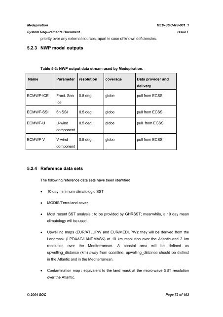
5.2.3 NWP model outputs<br />
Table 5-3: NWP output data stream used by <strong>Medspiration</strong>.<br />
Name Parameter resolution coverage <strong>Data</strong> provider and<br />
delivery<br />
ECMWF-ICE<br />
Fract. Sea<br />
Ice<br />
0.5 deg. globe pull from ECSS<br />
ECMWF-SSI 6h SSI 0.5 deg. globe pull from ECSS<br />
ECMWF-U<br />
ECMWF-V<br />
U-wind<br />
component<br />
V-wind<br />
component<br />
0.5 deg. globe pull from ECSS<br />
0.5 deg. globe pull from ECSS<br />
5.2.4 Reference data sets<br />
The following reference data sets have been identified<br />
• 10 day minimum climatologic SST<br />
• MODIS/Terra land cover<br />
• Most recent SST analysis : to be provided by GHRSST; meanwhile, a 10 day mean<br />
climatology will be used.<br />
• Upwelling maps (EUR/ATLUPW and EUR/MEDUPW): they will be derived from the<br />
Landmask (LPDAAC/LANDMASK) at 10 km resolution over the Atlantic and 2 km<br />
resolution over the Mediterranean. A coastal area will be defined as<br />
upwelling_distance (km) away from coastline, upwelling_distance should be distinct<br />
in the Atlantic and in the Mediterranean.<br />
• Contamination map : equivalent to the land mask at the micro-wave SST resolution<br />
over the Atlantic.<br />
© 2004 SOC Page 72 of 193