


You also want an ePaper? Increase the reach of your titles
YUMPU automatically turns print PDFs into web optimized ePapers that Google loves.
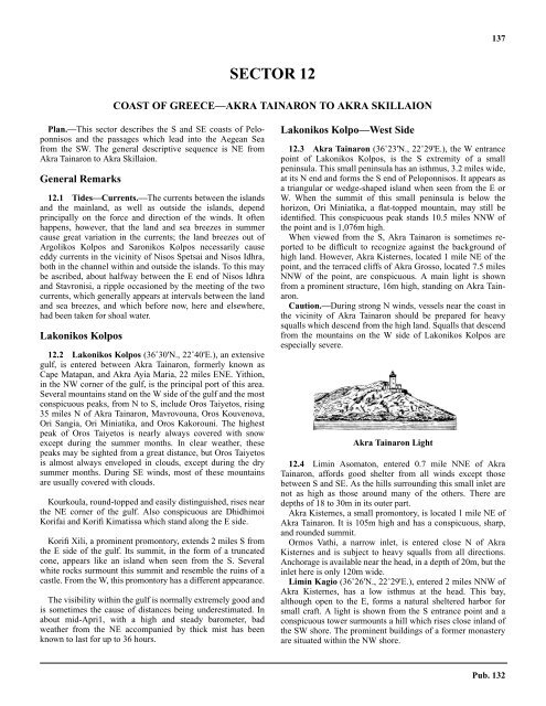
137SECTOR 12COAST OF GREECE—AKRA TAINARON TO AKRA SKILLAION12.0 Plan.—This sector describes the S and SE coasts of Peloponnisosand the passages which lead into the Aegean Seafrom the SW. The general descriptive sequence is NE fromAkra Tainaron to Akra Skillaion.General Remarks12.1 Tides—Currents.—The currents between the islandsand the mainland, as well as outside the islands, dependprincipally on the force and direction of the winds. It oftenhappens, however, that the land and sea breezes in summercause great variation in the currents; the land breezes out ofArgolikos Kolpos and Saronikos Kolpos necessarily causeeddy currents in the vicinity of Nisos Spetsai and Nisos Idhra,both in the channel within and outside the islands. To this maybe ascribed, about halfway between the E end of Nisos Idhraand Stavronisi, a ripple occasioned by the meeting of the twocurrents, which generally appears at intervals between the landand sea breezes, and which before now, here and elsewhere,had been taken for shoal water.Lakonikos Kolpos12.2 Lakonikos Kolpos (36˚30'N., 22˚40'E.), an extensivegulf, is entered between Akra Tainaron, formerly known asCape Matapan, and Akra Ayia Maria, 22 miles ENE. Yithion,in the NW corner of the gulf, is the principal port of this area.Several mountains stand on the W side of the gulf and the mostconspicuous peaks, from N to S, include Oros Taiyetos, rising35 miles N of Akra Tainaron, Mavrovouna, Oros Kouvenova,Ori Sangia, Ori Miniatika, and Oros Kakorouni. The highestpeak of Oros Taiyetos is nearly always covered with snowexcept during the summer months. In clear weather, thesepeaks may be sighted from a great distance, but Oros Taiyetosis almost always enveloped in clouds, except during the drysummer months. During SE winds, most of these mountainsare usually covered with clouds.12.2 Kourkoula, round-topped and easily distinguished, rises nearthe NE corner of the gulf. Also conspicuous are DhidhimoiKorifai and Korifi Kimatissa which stand along the E side.12.2 Korifi Xili, a prominent promontory, extends 2 miles S fromthe E side of the gulf. Its summit, in the form of a truncatedcone, appears like an island when seen from the S. Severalwhite rocks surmount this summit and resemble the ruins of acastle. From the W, this promontory has a different appearance.12.2 The visibility within the gulf is normally extremely good andis sometimes the cause of distances being underestimated. Inabout mid-Apri1, with a high and steady barometer, badweather from the NE accompanied by thick mist has beenknown to last for up to 36 hours.Lakonikos Kolpo—West Side12.3 Akra Tainaron (36˚23'N., 22˚29'E.), the W entrancepoint of Lakonikos Kolpos, is the S extremity of a smallpeninsula. This small peninsula has an isthmus, 3.2 miles wide,at its N end and forms the S end of Peloponnisos. It appears asa triangular or wedge-shaped island when seen from the E orW. When the summit of this small peninsula is below thehorizon, Ori Miniatika, a flat-topped mountain, may still beidentified. This conspicuous peak stands 10.5 miles NNW ofthe point and is 1,076m high.12.3 When viewed from the S, Akra Tainaron is sometimes reportedto be difficult to recognize against the background ofhigh land. However, Akra Kisternes, located 1 mile NE of thepoint, and the terraced cliffs of Akra Grosso, located 7.5 milesNNW of the point, are conspicuous. A main light is shownfrom a prominent structure, 16m high, standing on Akra Tainaron.12.3 Caution.—During strong N winds, vessels near the coast inthe vicinity of Akra Tainaron should be prepared for heavysqualls which descend from the high land. Squalls that descendfrom the mountains on the W side of Lakonikos Kolpos areespecially severe.Akra Tainaron Light12.4 Limin Asomaton, entered 0.7 mile NNE of AkraTainaron, affords good shelter from all winds except thosebetween S and SE. As the hills surrounding this small inlet arenot as high as those around many of the others. There aredepths of 18 to 30m in its outer part.12.4 Akra Kisternes, a small promontory, is located 1 mile NE ofAkra Tainaron. It is 105m high and has a conspicuous, sharp,and rounded summit.12.4 Ormos Vathi, a narrow inlet, is entered close N of AkraKisternes and is subject to heavy squalls from all <strong>directions</strong>.Anchorage is available near the head, in a depth of 20m, but theinlet here is only 120m wide.12.4 Limin Kagio (36˚26'N., 22˚29'E.), entered 2 miles NNW ofAkra Kisternes, has a low isthmus at the head. This bay,although open to the E, forms a natural sheltered harbor forsmall craft. A light is shown from the S entrance point and aconspicuous tower surmounts a hill which rises close inland ofthe SW shore. The prominent buildings of a former monasteryare situated within the NW shore.Pub. 132


