


You also want an ePaper? Increase the reach of your titles
YUMPU automatically turns print PDFs into web optimized ePapers that Google loves.
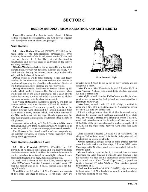
61SECTOR 6RODHOS (RHODES), NISOS KARPATHOS, AND KRITI (CRETE)6.0 Plan.—This sector describes the main islands of NisosRodhos (Rhodes), Nisos Karpathos, and Kriti (Crete) togetherwith the adjacent smaller islands and passages.Nisos Rodhos6.1 Nisos Rodhos (Rhodes) (36˚10'N., 27˚55'E.) is themain island of the Dhodhekanisos (Dodecanese). OrosAtaviros, the summit of the island, stands on the W side andrises to a height of 1,219m. The center of the island ismountainous and there are areas of cultivation in the valleysand along the coasts.6.1 Winds—Weather.—Rodhos has an agreeable and healthfulclimate. It is never very hot during the summer, as a steady NWwind prevails. During this season, vessels may anchor withsafety off the E shore of the island.6.1 During winter S winds blow, bringing cloudy and foggyweather; in this season vessels must navigate with caution inthe channel separating the island from the mainland. Southeastwinds attain considerable violence and raise heavy seas.6.1 During winter months, the E coast of Rodhos is beset by SEwinds, which render it inaccessible. During summer, whenwinds from the W are almost continuous, the E coast affordsshelter for vessels; however, this wind is sometimes so violentthat communication with the shore is impossible.6.1 The W side of Rodhos is inaccessible during W winds in thesummer and also with winds between NW and SE in winter.6.1 Tides—Currents.—The current generally sets W in thechannel between Akra Milon and the Turkish mainland. NearAkra Milon, a strong current, which, with winds between Nand NW, tends to set onto the cape. Vessels approaching thecape must exercise caution during winds from either the NW orNE quadrant.6.1 A current, with a velocity of 0.7 to 1.5 knots, sets NW over abank extending SSW from Rodhos; during NW winds there isa cross sea, which is dangerous to deeply-laden small vessels.6.1 The SE coast of the island provides safe anchorage duringthe summer. However, in winter, S winds frequently bringcloudy and foggy weather.Nisos Rodhos—Southeast Coast6.2 Akra Prasonisi (35˚52'N., 27˚45'E.), the SWextremity of Rodhos, is the seaward end of a rocky peninsulawhich is connected to the island by a low and sandy isthmus. Itis often mistaken for an island. A main light is shown from aprominent structure, 14m high, standing on this point.6.2 A bank, with a depth of less than 200m, extends up to 8miles SSW of Akra Prasonisi. A current is reported to set NWover this bank at rates up to 1.5 knots, causing a cross sea duringNW winds.6.2 Nisos Khina lies 7.5 miles E of Akra Prasonisi and consistsof two small and steep-to islets, 2 to 4m high. They areAkra Prasonisi Lightreported to be difficult to see by day in low visibility and aredangerous at night.6.2 Akra Katabia (Akra Katavia) is located 2.3 miles ENE ofAkra Prasonisi. A shoal, with a least depth of 4.6m, lies about0.6 mile E of this cape.6.2 Akra Vigli, located 2.8 miles ENE of Akra Katabia, is a lowpoint which is fronted by foul ground and surmounted by aprominent black tower.6.2 Akra Istros, located 1 mile NE of Akra Vigli, is whitish incolor and a hill, 50m high, stands near it. A dangerous wrecklies about 0.2 mile SW of this cape.6.2 Plimiri, a village, stands close W of Akra Istros and can beidentified by several small buildings surrounded by a whitewall. The village is fronted by a small pier which is used bysmall craft. Vessels can anchor, in a depth of 10m, sand, about400m SSW of the pier. Vessels can also anchor, in depths of 10to 12m, off the bight lying between Akra Istros and AkraLakhania.6.2 Akra Lakhania is located 2.5 miles NE of Akra Istros. Thevillage of Lakhania is situated 1.5 miles W of the point and canbe identified by several windmills.6.2 Ormos Yemadhi, a straight stretch of coast, extends betweenAkra Lakhania and Akra Merminga, 6.5 miles NNE. AkraMerminga is the N of two small projections which extend SEfrom the coast.6.2 Ormos Lardhos, open to the S, is entered between AkraMerminga and Akra Lindhos, 6 miles E. Akra Lindhos is theSE extremity of a high and flat promontory and is surmountedby a ruined tower. Cape Yenuri (Cape Ianuri), a prominentpoint, is located 1.7 miles WNW of Akra Lindhos; severalhouses stand on it.6.2 Vrakhos Paximadha (36˚01'N., 28˚05'E.), high and steepto,lies 2 miles S of Akra Lindhos. A main light is shown froma structure standing on this rock.Pub. 132


