150 Sector 13. Coast of Greece—Saronikos Kolpos13.11 Nisis Arsidha, 137m high, lies 0.5 mile SW of the Nentrance point of Ormos Anavissou.13.11 Vrakhoi Kouthounoi, a shallow and rocky spit, extends 1mile SW from a point on the coast located 1 mile N of the Nentrance point of Ormos Anavissou.13.11 Akra Zostir is located 7 miles NW of Nisis Arsidha. Thecoast between recedes and forms a bay which is fronted byseveral islets and rocks which lie up to 1.4 miles from theshore. Due to these dangers, vessels are advised to give thisarea a wide berth.13.11 Ormos Vouliagmenis, a small inlet, is entered between AkraZostir and the S end of Khersonisos Lomvardha, a smallpeninsula, 0.7 mile W. A conspicuous hotel stands on KhersonisosLomvardha and Vrakhonisis Kasidhis, a rock, islocated 0.3 mile SSW of the S extremity. This rock is 10m highand lies on a shoal bank which extends up to about 0.6 mileseaward. The inlet has depths of 5 to 10m and affords goodanchorage.13.11 Nisis Fleves (37˚46'N., 23˚46'E.), 93m high, lies 1.8 milesSSW of the entrance to Ormos Vouliagmenis. This island isfringed by rocks and a small islet lies close off its NE extremity.A main light is shown from a structure standing on the SWside of this island.13.11 Caution.—All vessels, except naval vessels, are prohibitedfrom anchoring within Ormos Vouliagmenis without permissionof the authorities.13.12 Akra Kavouri (37˚49'N., 23˚46'E.), 40m high, is theW extremity of a wooded peninsula and is surmounted by twoprominent radio masts. Kavouronisi, a small islet, lies close Wof this point. Ifalos Kakowidhi, a rocky shoal, lies about 1 mileN of Akra Kavouri and has a least depth of 3m.13.12 Prasonisi, a small islet, lies 1.5 miles NNW of Akra Kavouriand is connected to the coast by a shallow shoal bank.13.12 Vrakhoi Mermingia, consisting of a group of above andbelow-water rocks, lies 2 miles NW of Akra Kavouri and ismarked by a lighted beacon.13.12 Akra Kolias, surmounted by a small chapel, is located 5.2miles NW of Akra Kavouri. A rocky and shallow spit extendsup to 0.5 mile SW from the vicinity of this point and is markedby a lighted beacon. An airport, with an aeronautical light, issituated 0.5 mile SE of the point.13.12 Piraikis Khersonisos (37˚56'N., 23˚38'E.) is located 5 milesNW of Akra Kolias and is surmounted by the buildings of thecity of Piraievs. This peninsula has white and reddish-coloredcliffs and appears as an island when viewed from about 10miles to the S. Ormos Falirou, a large bay, is entered 1 mile Eof the peninsula. Several small boat harbors and yacht marinas,protected by breakwaters, front the coast and the shores of thebays lying between Akra Kolias and Piraikis Khersonisos.13.13 Nisis Psittalia (37˚56'N., 23˚35'E.), an island, lies onthe NW side of the SW approach to Piraievs. A main light isshown from a prominent structure, 14m high, standing at theNE end. Several white tombs, resembling beacons, are situatednear this light. The summit of the island rises near the middle.It is 45m high and is surmounted by a monument with a mast.A light is shown from the SW extremity of the island. A wrecklies about 0.2 mile off the N coast of the island, 0.5 mile NE ofthe SW extremity; it has a depth of 18m. A dangerous wreck isreported to lie about 1.8 miles SSE of the E end of NisisPsittalia.13.13 Poros Themistokleous, 0.3 mile wide, is the strait leadingbetween the E side of Nisis Psittalia and the mainland. PorosAiyiniton is the strait leading NW of the island.13.13 Nisis Atalandi, marked by a light, lies 0.4 mile WSW of theSW extremity of Nisis Psittalia. This islet is surrounded by ashallow bank which extends 0.4 mile WSW from its W side.Several stranded wrecks lie on this bank.13.13 Dangerous wrecks are reported to lie about 0.4 mile SSWand 0.7 mile S of Nisis Atalandi. Another dangerous wreck liesclose NW of the island.13.13 Vrakhoi Skrofes, a group of above and below-water rocks,lies on a shoal about 0.9 mile WSW of Nisis Atalandi.13.13 Caution.—A prohibited area, which may best be seen on thechart, extends 0.1 mile seaward from the coast of Nisis Psittalia.13.13 Submarine pipelines, which may best be seen on the chart,extend up to 0.8 mile seaward of the S side of Nisis Psittaliaand anchoring and fishing are prohibited in their vicinity. Dueto the existence of submarine cables, a prohibited anchoragearea, which may best be seen on the chart, extends between theE end of Nisis Psittalia and the mainland.13.13 Anchoring is prohibited in the approaches to Ormos Baikhoutsi,a small cove, which indents the SW end of PiraikisKhersonisos.13.13 Vessels without permission are prohibited from enteringOrmos Kanellopoulou, a small cove, which fronts the navalcollege at the W side of Piraikis Khersonisos.Piraievs (37˚56'N., 23˚38'E.)World Port Index No. 4223013.14 Piraievs, the port for Athinai (Athens), is formed byan inlet which indents the coast between the N side of PiraikisKhersonisos and the S side of Dhrapetsona, an industrial area.It consists of three harbor basins. Prolimin, the outer harbor;Limin Kendrikos, the main or central harbor; and Limin Alon,the inner harbor which is used by small local vessels andferries.13.14 Annexes to the port, which are described later, include LiminForon (paragraph 13.15), Limin Dhrapetsona (paragraph13.15), Hercules Port (Limin Irakleous) (paragraph 13.17), andthe Perama coast facilities (paragraph 13.17).13.14 Depths—Limitations.—The entrance to the harbor ofPiraievs is protected by two breakwaters, the heads of whichshould be given a wide berth, and has a depth of 26m.13.14 The harbor has 6,800m of total berthing space, with depthsof 3.2 to 12m alongside. There are facilities for general cargo,container, passenger, cruise, and ro-ro vessels. The maximumallowable draft for Piraevs is 10.9m (1998).13.14 The port annexes also have extensive repair facilities withseveral dry docks. The largest dry dock is 420m long and 75mwide and can handle vessels of up to 500,000 dwt.13.14 Aspect.—From the S approaches, the buildings andacropolis of Athinai, standing 4.2 miles NE of Piraievs and 2.5miles inland, are plainly visible. The buildings of the city ofPiraievs, standing on Piraikis Khersonisos, are also prominent.A signal station surmounts a conspicuous silo which stands onPub. 132
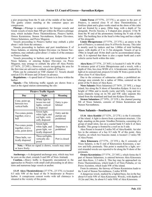
Sector 13. Coast of Greece—Saronikos Kolpos 151a pier projecting from the N side of the middle of the harbor.The gantry cranes standing at the container quays areconspicuous.13.14 Pilotage.—Pilotage is compulsory for foreign vessels andGreek vessels of more than 500 grt within the Piraievs pilotagearea, which includes Poros Themistokleous, Piraievs harbor,Ormos Keratsiniou, Stenon Navstathmou, Kolpos Elevsinos,Ormos Salaminos, and Poros Megaron.13.14 Vessels proceeding to Piraievs harbor may embark a pilotabout 1 mile from the entrance.13.14 Vessels proceeding to harbors and port installations E ofNisos Salamis, or entering Kolpos Elevsinos via Stenon Navstathmou,may embark a pilot about 1.5 miles S of the entranceto Piraievs harbor.13.14 Vessels proceeding to harbors and port installations W ofNisos Salamis, or entering Kolpos Elevsinos via PorosMegaron, may arrange to embark the pilot off Akra Petritis(37˚56'N., 23˚24'E.). However, vessels navigating the area forthe first time are advised to embark a pilot off Piraievs.13.14 Pilots can be contacted on VHF channel 12. Vessels shouldsend an ETA 48 hours and 24 hours in advance.13.14 Regulations.—A speed limit of 5 knots is in force within theharbor.13.14 Signals.—The following traffic signals are shown from amast at the signal station surmounting the silo:Piraievs Traffic SignalsDay Night MeaningCone, point up,between twovertical ballsTwo cones, pointstogether, over aballTwo cones, pointstogether, over acone, point downThree balls, verticallydisposedWhite light betweentwo redlights, verticallydisposedGreen light,white light, andred light, verticallydisposedGreen light,white light, andgreen light, verticallydisposedThree red lights,vertically disposedEntry is prohibitedEntry and departureareprohibitedDeparture isprohibitedPort is closedNote.—When no signal is shown, vessels may enteror leave freely.13.14 Anchorage.—A designated anchorage area, which may bestbe seen on the chart, extends S and SW of Nisis Atalandi.13.14 Caution.—Heavy traffic is frequently encountered in theapproaches to Piraievs with small craft proceeding in all <strong>directions</strong>and numerous large vessels at anchor.13.15 Akra Themistokleous (37˚57'N., 23˚37'E.) is located0.5 mile NW of the head of the N breakwater at Piraievsharbor. A conspicuous cement works with tall chimneys issituated in the vicinity of this point.13.15 Limin Foron (37˚57'N., 23˚37'E.), an annex to the port ofPiraievs, is entered close N of Akra Themistokleous. Afertilizer plant and a glass works stand on the shore of this inletand are fronted by a quay, 200m long, with a depth of 7malongside. Provlis Socony, a T-shaped pier, projects 115m Wfrom the W end of the promontory forming the N side of thisinlet. The berthing face at the head is 64m long and has a depthof 9m alongside.13.15 Limin Dhrapetsonas (37˚57'N., 23˚37'E.), an annex to theport of Piraievs, is entered close N of Provlis Socony. This inletis mostly used by tankers and has 1,000m of total berthingspace, with depths of 5 to 11.5m alongside. Vessels of up to198m in length and 10.6m draft can be accommodated alongside.It is reported that there is also a repair berth and a newvehicle carrier berth within this inlet.13.15 Akra Keos (37˚57'N., 23˚36'E.) is located 0.3 mile W of theN entrance point of Limin Dhrapetsonas and a wreck, with adepth of 18m, lies close WSW of it. A breakwater, marked by alight at its seaward end, projects 0.4 mile W from a point on theshore close N of Akra Keos.13.15 Due to the existence of submarine cables, a prohibited anchoragearea extends for a radius of 300m, centered on thepoint of the N shore of Akra Keos.Nisos Salamis (Nisis Salamina) (37˚56'N., 23˚30'E.), a largeisland, lies along the N shore of Saronikos Kolpos. It rises to aheight of 390m and is mostly rocky and hilly. Long and tortuouschannels lying on its NE and NW sides separate thisisland from the mainland and lead into Kolpos Elevsinas.13.15 Stenon Salaminos (37˚59'N., 23˚33'E.), the channel passingNE of Nisos Salamis, consists of Ormos Keratsiniou andStenon Navstathmou.Nisos Salamis—Southeast Side13.16 Akra Konkhi (37˚52'N., 23˚27'E.) is the S extremityof the island. A light is shown from a prominent structure, 12mhigh, standing on this point. Nisidhes Peristeria, consisting of agroup of small islets, lies on a coastal bank 0.5 mile E of AkraKonkhi. This group is fronted by a reef on its S side.13.16 Akra Perani is located 4.2 miles NE of Akra Konkhi. An isletlies in the entrance of a bay 0.5 mile W of this point. AkraTourlos, on which two beacons stand, is located 1.3 miles NEof Akra Perani.13.16 Akra Kinosoura (37˚57'N., 23˚35'E.), the E extremity ofNisos Salamis, is the E end of Khersonisos Kinosoura, a narrowand hilly peninsula. This point is marked by a light; severalstranded wrecks are reported to lie along the N shore of thepeninsula.13.16 Ormos Keratsiniou (37˚57'N., 23˚34'E.), which forms the Spart of Stenon Salaminos, is entered between Akra Kinosouraand Akra Keos, 1.2 miles E. This bay may be approached viaPoros Themistokleous, which leads E of Nisis Psittalia, or viaPoros Aiyiniton, which leads NW of the island.13.16 From its entrance, the fairway of Ormos Keratsiniou leads tothe S end of Stenon Navstathmou, 2 miles WNW.13.16 A dangerous wreck, marked by a lighted buoy, lies in the bayabout 0.4 mile NW of Akra Kinosoura. Wrecks, with depths of18.2m and 24m, lie about 0.3 mile NNE of Akra Kinosoura.Pub. 132
- Page 1 and 2:
PUB.132SAILING DIRECTIONS(ENROUTE)
- Page 3 and 4:
Preface0.0 Pub. 132, Sailing Direct
- Page 5 and 6:
ContentsHow to Keep this Book Corre
- Page 7 and 8:
0.0SECTOR LIMITS—PUB. 132Pub. 132
- Page 9:
AbbreviationsThe following abbrevia
- Page 13 and 14:
3SECTOR 1COAST OF LIBYA1.0 Plan.—
- Page 15 and 16:
Sector1.CoastofLibya 51.5 Pilotage.
- Page 17 and 18:
Sector1.CoastofLibya 71.12 Caution.
- Page 19 and 20:
Sector1.CoastofLibya 91.17 Jabal La
- Page 21 and 22:
Sector1.CoastofLibya 111.21 Tukrah
- Page 23:
Sector1.CoastofLibya 131.28 Aspect.
- Page 27 and 28:
17SECTOR 2COAST OF EGYPT2.0 Plan.
- Page 29 and 30:
Sector2.CoastofEgypt 19a depth of 2
- Page 31 and 32:
Sector2.CoastofEgypt 212.10 Several
- Page 33 and 34:
Sector2.CoastofEgypt 232.17 Local v
- Page 35:
Sector2.CoastofEgypt 25high, stands
- Page 39 and 40:
29SECTOR 3COASTS OF ISRAEL, LEBANON
- Page 41 and 42:
Sector 3. Coasts of Israel, Lebanon
- Page 43 and 44:
Sector 3. Coasts of Israel, Lebanon
- Page 45 and 46:
Sector 3. Coasts of Israel, Lebanon
- Page 47 and 48:
Sector 3. Coasts of Israel, Lebanon
- Page 49:
4.CyprusPub. 1324.0Additional chart
- Page 52 and 53:
42 Sector4.Cyprusthe village. Ancho
- Page 54 and 55:
44 Sector4.Cyprus4.10 A conspicuous
- Page 56 and 57:
46 Sector4.Cyprus4.18 Kakoskaliou I
- Page 59 and 60:
49SECTOR 5SOUTH COAST OF TURKEY—K
- Page 61 and 62:
Sector 5. South Coast of Turkey—K
- Page 63 and 64:
Sector 5. South Coast of Turkey—K
- Page 65 and 66:
Sector 5. South Coast of Turkey—K
- Page 67:
Sector 5. South Coast of Turkey—K
- Page 71 and 72:
61SECTOR 6RODHOS (RHODES), NISOS KA
- Page 73 and 74:
Sector 6. Rodhos (Rhodes), Nisos Ka
- Page 75 and 76:
Sector 6. Rodhos (Rhodes), Nisos Ka
- Page 77 and 78:
Sector 6. Rodhos (Rhodes), Nisos Ka
- Page 79 and 80:
Sector 6. Rodhos (Rhodes), Nisos Ka
- Page 81 and 82:
Sector 6. Rodhos (Rhodes), Nisos Ka
- Page 83:
7.West Coast of Greece and Dhiorix
- Page 86 and 87:
76 Sector 7. West Coast of Greece a
- Page 88 and 89:
78 Sector 7. West Coast of Greece a
- Page 90 and 91:
80 Sector 7. West Coast of Greece a
- Page 93:
8.West Coasts of Greece and Albania
- Page 96 and 97:
86 Sector 8. West Coasts of Greece
- Page 98 and 99:
88 Sector 8. West Coasts of Greece
- Page 100 and 101:
90 Sector 8. West Coasts of Greece
- Page 102 and 103:
92 Sector 8. West Coasts of Greece
- Page 105:
9.Coasts of Albania, Montenegro, an
- Page 108 and 109:
98 Sector 9. Coasts of Albania, Mon
- Page 110 and 111: 100 Sector 9. Coasts of Albania, Mo
- Page 112 and 113: 102 Sector 9. Coasts of Albania, Mo
- Page 114 and 115: 104 Sector 9. Coasts of Albania, Mo
- Page 117: 10.Coasts of Croatia and Bosnia-Her
- Page 120 and 121: 110 Sector 10. Coasts of Croatia an
- Page 122 and 123: 112 Sector 10. Coasts of Croatia an
- Page 124 and 125: 114 Sector 10. Coasts of Croatia an
- Page 126 and 127: 116 Sector 10. Coasts of Croatia an
- Page 128 and 129: 118 Sector 10. Coasts of Croatia an
- Page 131 and 132: 121SECTOR 11COAST OF CROATIA—RT M
- Page 133 and 134: Sector 11. Coast of Croatia—Rt Mo
- Page 135 and 136: Sector 11. Coast of Croatia—Rt Mo
- Page 137 and 138: Sector 11. Coast of Croatia—Rt Mo
- Page 139 and 140: Sector 11. Coast of Croatia—Rt Mo
- Page 141 and 142: Sector 11. Coast of Croatia—Rt Mo
- Page 143: Sector 11. Coast of Croatia—Rt Mo
- Page 147 and 148: 137SECTOR 12COAST OF GREECE—AKRA
- Page 149 and 150: Sector 12. Coast of Greece—Akra T
- Page 151 and 152: Sector 12. Coast of Greece—Akra T
- Page 153 and 154: Sector 12. Coast of Greece—Akra T
- Page 155: 13.Coast of Greece—Saronikos Kolp
- Page 158 and 159: 148 Sector 13. Coast of Greece—Sa
- Page 162 and 163: 152 Sector 13. Coast of Greece—Sa
- Page 164 and 165: 154 Sector 13. Coast of Greece—Sa
- Page 167: 14.Greece—Kikladhes Nisoi15714.0A
- Page 170 and 171: 160 Sector14.Greece—KikladhesNiso
- Page 172 and 173: 162 Sector14.Greece—KikladhesNiso
- Page 174 and 175: 164 Sector14.Greece—KikladhesNiso
- Page 176 and 177: 166 Sector14.Greece—KikladhesNiso
- Page 178 and 179: 168 Sector14.Greece—KikladhesNiso
- Page 181: 15.Greece—Channels West of Nisos
- Page 184 and 185: 174 Sector 15. Greece—Channels We
- Page 186 and 187: 176 Sector 15. Greece—Channels We
- Page 188 and 189: 178 Sector 15. Greece—Channels We
- Page 191: 16.Greece—Nisoi Vorioi Sporadhes
- Page 194 and 195: 184 Sector 16. Greece—Nisoi Vorio
- Page 196 and 197: 186 Sector 16. Greece—Nisoi Vorio
- Page 199: 17.Coast of Greece—Thermaikos Kol
- Page 202 and 203: 192 Sector 17. Coast of Greece—Th
- Page 204 and 205: 194 Sector 17. Coast of Greece—Th
- Page 206 and 207: 196 Sector 17. Coast of Greece—Th
- Page 209: 18.Greece—Dhodhekanisos and South
- Page 212 and 213:
202 Sector 18. Greece—Dhodhekanis
- Page 214 and 215:
204 Sector 18. Greece—Dhodhekanis
- Page 216 and 217:
206 Sector 18. Greece—Dhodhekanis
- Page 219:
19.West Coast of Turkey—Samos Str
- Page 222 and 223:
212 Sector 19. West Coast of Turkey
- Page 224 and 225:
214 Sector 19. West Coast of Turkey
- Page 226 and 227:
216 Sector 19. West Coast of Turkey
- Page 229:
20.The Dardanelles Approach and Adj
- Page 232 and 233:
222 Sector 20. The Dardanelles Appr
- Page 234 and 235:
224 Sector 20. The Dardanelles Appr
- Page 236 and 237:
226 Sector 20. The Dardanelles Appr
- Page 238 and 239:
228 Sector 20. The Dardanelles Appr
- Page 240 and 241:
230 GlossariesArabicARABICEnglishAR
- Page 242 and 243:
232 GlossariesARABICEnglishARABICEn
- Page 244 and 245:
234 GlossariesHebrewHEBREWEnglishHE
- Page 246 and 247:
236 GlossariesTURKISHEnglishTURKISH
- Page 249 and 250:
How to use the Index—Gazetteer239
- Page 251 and 252:
Index—Gazetteer 241PositionSec.˚
- Page 253 and 254:
Index—Gazetteer 243PositionSec.˚
- Page 255 and 256:
Index—Gazetteer 245PositionSec.˚
- Page 257 and 258:
Index—Gazetteer 247PositionSec.˚