32 Sector 3. Coasts of Israel, Lebanon, and Syria3.9 Quay 12, with a length of 224m and an alongside depth of8m, accommodates ro-ro vessels and ferry traffic.3.9 The East Quay is 650m long and has alongside depths of 12to 13.5m for container and bulk vessels.3.9 The Kishon Zone extends E of the main port and is enclosedby breakwaters. The approach channel to the zone is 0.5 milein length, with a width of 80m and a depth of 12m.3.9 The Kishon Zone contains docks and facilities for chemicaland general cargo, a fishery dock, and a marina. Quay 1through Quay 4 have a total length of 625m, with an alongsidedepth of 10m, for the handling of general cargo. The NorthChemical Terminal and the South Chemical Terminal have acombined docking length of 410m, with alongside depths of upto 9m.3.9 Shipbuilding and ship repair facilities are available at twofloating dockyard quays, with depths of up to 11.5m3.9 An offshore tanker berth, consisting of several mooringbuoys, lies in depths of 14 to 15.5m about 1.5 miles NNE ofthe head of the main breakwater. Tankers with a maximumdraft of 12m can be accommodated.3.9 Aspect.—Prominent landmarks in the approaches are describedwith Cape Carmel in paragraph 3.7. A new and veryconspicuous high building is reported to stand in the vicinity ofthe hospital, 0.9 mile ENE of the main light.3.9 Pilotage.—Pilotage is compulsory. Pilots can be contactedon VHF channel 14 and board between 0.5 and 1.5 miles N ofthe head of the main breakwater. Pilots are also provided forthe offshore chemical berth in the NE part of the bay. Vesselsshould also check in with the Israeli Navy on VHF channel 16prior to entering Israeli territorial waters.3.9 Anchorage.—A designated tanker anchorage area, whichmay best be seen on the chart, lies centered 2 miles NW of thehead of the main breakwater.3.9 During summer, vessels can anchor off the port in any convenientdepth and clear of the prohibited areas. The depths areregular, the bottom is sand, and the holding ground is good. Inbad weather, the sea breaks in exposed places where the depthsare less than 5m.3.9 Caution.—An anchoring and fishing prohibited area, whichmay best be seen on the chart, lies in the inner approaches tothe port.3.9 Several prohibited areas, which may best be seen on thechart, lie in the outer approaches to the port.3.9 A wreck, with a depth of 29m, lies about 4.8 miles N of CapeCarmel and is marked by a lighted buoy. The wreck is identifiedas R. SMG. SCIRE, an Italian submarine sunk duringWorld War I, and is designated a war memorial containing theinterred remains of Italian sailors. Underwater activity shouldbe avoided in the vicinity of this wreck.Haifa to Sidon3.10 Ras en Naqurah (Rosh HaNiqra) (33˚06'N.,35˚06'E.), located 10.5 miles N of Akko, is a prominent whiteheadland, 79m high, which is surmounted by a tower. A conspicuousround-topped peak stands 1.7 miles E of the headlandand the land rises gradually towards it.3.10 Between Akko and Ras an Naqurah, several settlements standnear the coast. Nahariyya, a large settlement, is situated 4.5 milesS of Ras en Naqurah and contains a prominent water tower, 45mhigh. A conspicuous arched aqueduct stands 2.7 miles S of thissettlement. Reefs, with a least depth of 4.5m, front the S part ofNahariyya and extend up to 1.2 miles offshore.3.10 The coastal boundary between Israel and Lebanon lies in thevicinity of Ras en Naqurah.3.10 Caution.—Prohibited areas, which may best be seen on thechart, front the coast between Akko and Ras an Naqurah.3.10 Ar Ras al Abyad (Ras el Baiyada) (33˚09'N., 35˚10'E.), acape, is formed by a bold white cliff which is surmounted bythe ruins of an ancient temple. It is W termination of the JebelBelat, a range of hills, which rises to a height of 778m about6.5 miles ESE. A prominent table-topped hill, 371m high,stands 1.8 miles SE of the cape.3.11 Sur (Sour) (33˚16'N., 35˚11'E.), formerly known asTyr, is a small town situated on a low and flat peninsula. Amain light is shown from a structure standing on the N end ofthis peninsula and a prominent tower is situated 0.4 mile SSEof it. A conspicuous white building stands on a rocky mound,40m high, 1.6 miles ESE of the light.3.11 A chain of low islets, rocks, and shoals extends up to about0.7 mile N of the light3.11 A small harbor, protected by breakwaters, lies on the N sideof the peninsula. It is mostly silted up and is only used by smallcraft. It was reported (1990) that a pier, with a depth of 5.3malongside its head, was used by ro-ro vessels.3.11 Large vessels may anchor, in depths of 15 to 17m, sand andweed, about 1.8 miles NNE of the light and NW of the whitebuilding. Small vessels may anchor E of the chain of islets andshoals. A good berth is in depths of 7 to 11m, sand, about 0.6mile NE of the light.3.11 Nahr al Litani, a large river, flows into the sea 4.5 miles NNEof Sur. Two prominent bridges span this river within 0.5 mileof its entrance.3.11 Jabal Ash Shaykh (Mount Hermon) rises 30 miles inland ofthe mouth of the river. Its isolated and snow-capped peak.2,814m high, is prominent from seaward.3.11 Ras Sarafand, a double headed bluff cliff, is located 6 milesNNE of Nahr al Litani and is skirted by low plains on bothsides. Several villages stand on the rising hills close inland ofthis cliff. A light is shown from a structure standing on an isletlying 0.8 mile W of the cliff. This islet is the outermost ofseveral dangers in this vicinity.3.11 Between Sur (Sour) and Sayde (Sidon), the coast is frontedby several islets, reefs, and rocks which extend up to 1.5 milesseaward in places.Sidon (Sayde) (Saide) (33˚30'N., 35˚21'E.)World Port Index No. 450403.12 Sidon, a petroleum port, consists of four berths, whichare connected to the Zahrani oil terminal by submarine pipelines,and fronts 5 miles of coastline.3.12 Tides—Currents.—The tidal rise is negligible, being only0.4m at springs.3.12 Normally, no current is experienced off Sidon. However,occasional strong S sets are experienced.Pub. 132
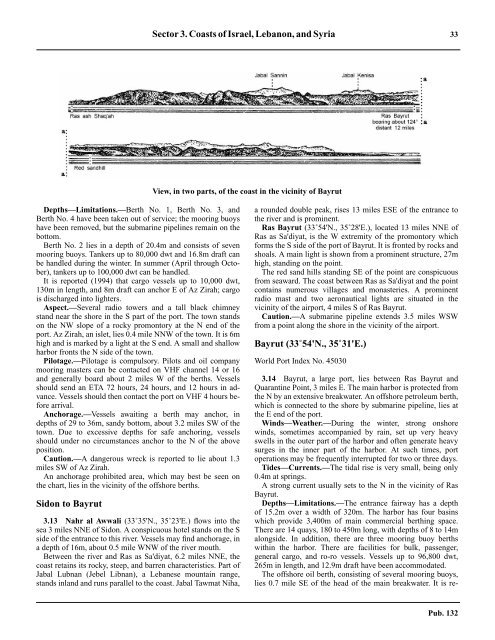
Sector 3. Coasts of Israel, Lebanon, and Syria 33View, in two parts, of the coast in the vicinity of Bayrut3.12 Depths—Limitations.—Berth No. 1, Berth No. 3, andBerth No. 4 have been taken out of service; the mooring buoyshave been removed, but the submarine pipelines remain on thebottom.3.12 Berth No. 2 lies in a depth of 20.4m and consists of sevenmooring buoys. Tankers up to 80,000 dwt and 16.8m draft canbe handled during the winter. In summer (April through October),tankers up to 100,000 dwt can be handled.3.12 It is reported (1994) that cargo vessels up to 10,000 dwt,130m in length, and 8m draft can anchor E of Az Zirah; cargois discharged into lighters.3.12 Aspect.—Several radio towers and a tall black chimneystand near the shore in the S part of the port. The town standson the NW slope of a rocky promontory at the N end of theport. Az Zirah, an islet, lies 0.4 mile NNW of the town. It is 6mhigh and is marked by a light at the S end. A small and shallowharbor fronts the N side of the town.3.12 Pilotage.—Pilotage is compulsory. Pilots and oil companymooring masters can be contacted on VHF channel 14 or 16and generally board about 2 miles W of the berths. Vesselsshould send an ETA 72 hours, 24 hours, and 12 hours in advance.Vessels should then contact the port on VHF 4 hours beforearrival.3.12 Anchorage.—Vessels awaiting a berth may anchor, indepths of 29 to 36m, sandy bottom, about 3.2 miles SW of thetown. Due to excessive depths for safe anchoring, vesselsshould under no circumstances anchor to the N of the aboveposition.3.12 Caution.—A dangerous wreck is reported to lie about 1.3miles SW of Az Zirah.3.12 An anchorage prohibited area, which may best be seen onthe chart, lies in the vicinity of the offshore berths.Sidon to Bayrut3.13 Nahr al Awwali (33˚35'N., 35˚23'E.) flows into thesea 3 miles NNE of Sidon. A conspicuous hotel stands on the Sside of the entrance to this river. Vessels may find anchorage, ina depth of 16m, about 0.5 mile WNW of the river mouth.3.13 Between the river and Ras as Sa'diyat, 6.2 miles NNE, thecoast retains its rocky, steep, and barren characteristics. Part ofJabal Lubnan (Jebel Libnan), a Lebanese mountain range,stands inland and runs parallel to the coast. Jabal Tawmat Niha,a rounded double peak, rises 13 miles ESE of the entrance tothe river and is prominent.3.13 Ras Bayrut (33˚54'N., 35˚28'E.), located 13 miles NNE ofRas as Sa'diyat, is the W extremity of the promontory whichforms the S side of the port of Bayrut. It is fronted by rocks andshoals. A main light is shown from a prominent structure, 27mhigh, standing on the point.3.13 The red sand hills standing SE of the point are conspicuousfrom seaward. The coast between Ras as Sa'diyat and the pointcontains numerous villages and monasteries. A prominentradio mast and two aeronautical lights are situated in thevicinity of the airport, 4 miles S of Ras Bayrut.3.13 Caution.—A submarine pipeline extends 3.5 miles WSWfrom a point along the shore in the vicinity of the airport.Bayrut (33˚54'N., 35˚31'E.)World Port Index No. 450303.14 Bayrut, a large port, lies between Ras Bayrut andQuarantine Point, 3 miles E. The main harbor is protected fromthe N by an extensive breakwater. An offshore petroleum berth,which is connected to the shore by submarine pipeline, lies atthe E end of the port.3.14 Winds—Weather.—During the winter, strong onshorewinds, sometimes accompanied by rain, set up very heavyswells in the outer part of the harbor and often generate heavysurges in the inner part of the harbor. At such times, portoperations may be frequently interrupted for two or three days.3.14 Tides—Currents.—The tidal rise is very small, being only0.4m at springs.3.14 A strong current usually sets to the N in the vicinity of RasBayrut.3.14 Depths—Limitations.—The entrance fairway has a depthof 15.2m over a width of 320m. The harbor has four basinswhich provide 3,400m of main commercial berthing space.There are 14 quays, 180 to 450m long, with depths of 8 to 14malongside. In addition, there are three mooring buoy berthswithin the harbor. There are facilities for bulk, passenger,general cargo, and ro-ro vessels. Vessels up to 96,800 dwt,265m in length, and 12.9m draft have been accommodated.3.14 The offshore oil berth, consisting of several mooring buoys,lies 0.7 mile SE of the head of the main breakwater. It is re-Pub. 132
- Page 1 and 2: PUB.132SAILING DIRECTIONS(ENROUTE)
- Page 3 and 4: Preface0.0 Pub. 132, Sailing Direct
- Page 5 and 6: ContentsHow to Keep this Book Corre
- Page 7 and 8: 0.0SECTOR LIMITS—PUB. 132Pub. 132
- Page 9: AbbreviationsThe following abbrevia
- Page 13 and 14: 3SECTOR 1COAST OF LIBYA1.0 Plan.—
- Page 15 and 16: Sector1.CoastofLibya 51.5 Pilotage.
- Page 17 and 18: Sector1.CoastofLibya 71.12 Caution.
- Page 19 and 20: Sector1.CoastofLibya 91.17 Jabal La
- Page 21 and 22: Sector1.CoastofLibya 111.21 Tukrah
- Page 23: Sector1.CoastofLibya 131.28 Aspect.
- Page 27 and 28: 17SECTOR 2COAST OF EGYPT2.0 Plan.
- Page 29 and 30: Sector2.CoastofEgypt 19a depth of 2
- Page 31 and 32: Sector2.CoastofEgypt 212.10 Several
- Page 33 and 34: Sector2.CoastofEgypt 232.17 Local v
- Page 35: Sector2.CoastofEgypt 25high, stands
- Page 39 and 40: 29SECTOR 3COASTS OF ISRAEL, LEBANON
- Page 41: Sector 3. Coasts of Israel, Lebanon
- Page 45 and 46: Sector 3. Coasts of Israel, Lebanon
- Page 47 and 48: Sector 3. Coasts of Israel, Lebanon
- Page 49: 4.CyprusPub. 1324.0Additional chart
- Page 52 and 53: 42 Sector4.Cyprusthe village. Ancho
- Page 54 and 55: 44 Sector4.Cyprus4.10 A conspicuous
- Page 56 and 57: 46 Sector4.Cyprus4.18 Kakoskaliou I
- Page 59 and 60: 49SECTOR 5SOUTH COAST OF TURKEY—K
- Page 61 and 62: Sector 5. South Coast of Turkey—K
- Page 63 and 64: Sector 5. South Coast of Turkey—K
- Page 65 and 66: Sector 5. South Coast of Turkey—K
- Page 67: Sector 5. South Coast of Turkey—K
- Page 71 and 72: 61SECTOR 6RODHOS (RHODES), NISOS KA
- Page 73 and 74: Sector 6. Rodhos (Rhodes), Nisos Ka
- Page 75 and 76: Sector 6. Rodhos (Rhodes), Nisos Ka
- Page 77 and 78: Sector 6. Rodhos (Rhodes), Nisos Ka
- Page 79 and 80: Sector 6. Rodhos (Rhodes), Nisos Ka
- Page 81 and 82: Sector 6. Rodhos (Rhodes), Nisos Ka
- Page 83: 7.West Coast of Greece and Dhiorix
- Page 86 and 87: 76 Sector 7. West Coast of Greece a
- Page 88 and 89: 78 Sector 7. West Coast of Greece a
- Page 90 and 91: 80 Sector 7. West Coast of Greece a
- Page 93:
8.West Coasts of Greece and Albania
- Page 96 and 97:
86 Sector 8. West Coasts of Greece
- Page 98 and 99:
88 Sector 8. West Coasts of Greece
- Page 100 and 101:
90 Sector 8. West Coasts of Greece
- Page 102 and 103:
92 Sector 8. West Coasts of Greece
- Page 105:
9.Coasts of Albania, Montenegro, an
- Page 108 and 109:
98 Sector 9. Coasts of Albania, Mon
- Page 110 and 111:
100 Sector 9. Coasts of Albania, Mo
- Page 112 and 113:
102 Sector 9. Coasts of Albania, Mo
- Page 114 and 115:
104 Sector 9. Coasts of Albania, Mo
- Page 117:
10.Coasts of Croatia and Bosnia-Her
- Page 120 and 121:
110 Sector 10. Coasts of Croatia an
- Page 122 and 123:
112 Sector 10. Coasts of Croatia an
- Page 124 and 125:
114 Sector 10. Coasts of Croatia an
- Page 126 and 127:
116 Sector 10. Coasts of Croatia an
- Page 128 and 129:
118 Sector 10. Coasts of Croatia an
- Page 131 and 132:
121SECTOR 11COAST OF CROATIA—RT M
- Page 133 and 134:
Sector 11. Coast of Croatia—Rt Mo
- Page 135 and 136:
Sector 11. Coast of Croatia—Rt Mo
- Page 137 and 138:
Sector 11. Coast of Croatia—Rt Mo
- Page 139 and 140:
Sector 11. Coast of Croatia—Rt Mo
- Page 141 and 142:
Sector 11. Coast of Croatia—Rt Mo
- Page 143:
Sector 11. Coast of Croatia—Rt Mo
- Page 147 and 148:
137SECTOR 12COAST OF GREECE—AKRA
- Page 149 and 150:
Sector 12. Coast of Greece—Akra T
- Page 151 and 152:
Sector 12. Coast of Greece—Akra T
- Page 153 and 154:
Sector 12. Coast of Greece—Akra T
- Page 155:
13.Coast of Greece—Saronikos Kolp
- Page 158 and 159:
148 Sector 13. Coast of Greece—Sa
- Page 160 and 161:
150 Sector 13. Coast of Greece—Sa
- Page 162 and 163:
152 Sector 13. Coast of Greece—Sa
- Page 164 and 165:
154 Sector 13. Coast of Greece—Sa
- Page 167:
14.Greece—Kikladhes Nisoi15714.0A
- Page 170 and 171:
160 Sector14.Greece—KikladhesNiso
- Page 172 and 173:
162 Sector14.Greece—KikladhesNiso
- Page 174 and 175:
164 Sector14.Greece—KikladhesNiso
- Page 176 and 177:
166 Sector14.Greece—KikladhesNiso
- Page 178 and 179:
168 Sector14.Greece—KikladhesNiso
- Page 181:
15.Greece—Channels West of Nisos
- Page 184 and 185:
174 Sector 15. Greece—Channels We
- Page 186 and 187:
176 Sector 15. Greece—Channels We
- Page 188 and 189:
178 Sector 15. Greece—Channels We
- Page 191:
16.Greece—Nisoi Vorioi Sporadhes
- Page 194 and 195:
184 Sector 16. Greece—Nisoi Vorio
- Page 196 and 197:
186 Sector 16. Greece—Nisoi Vorio
- Page 199:
17.Coast of Greece—Thermaikos Kol
- Page 202 and 203:
192 Sector 17. Coast of Greece—Th
- Page 204 and 205:
194 Sector 17. Coast of Greece—Th
- Page 206 and 207:
196 Sector 17. Coast of Greece—Th
- Page 209:
18.Greece—Dhodhekanisos and South
- Page 212 and 213:
202 Sector 18. Greece—Dhodhekanis
- Page 214 and 215:
204 Sector 18. Greece—Dhodhekanis
- Page 216 and 217:
206 Sector 18. Greece—Dhodhekanis
- Page 219:
19.West Coast of Turkey—Samos Str
- Page 222 and 223:
212 Sector 19. West Coast of Turkey
- Page 224 and 225:
214 Sector 19. West Coast of Turkey
- Page 226 and 227:
216 Sector 19. West Coast of Turkey
- Page 229:
20.The Dardanelles Approach and Adj
- Page 232 and 233:
222 Sector 20. The Dardanelles Appr
- Page 234 and 235:
224 Sector 20. The Dardanelles Appr
- Page 236 and 237:
226 Sector 20. The Dardanelles Appr
- Page 238 and 239:
228 Sector 20. The Dardanelles Appr
- Page 240 and 241:
230 GlossariesArabicARABICEnglishAR
- Page 242 and 243:
232 GlossariesARABICEnglishARABICEn
- Page 244 and 245:
234 GlossariesHebrewHEBREWEnglishHE
- Page 246 and 247:
236 GlossariesTURKISHEnglishTURKISH
- Page 249 and 250:
How to use the Index—Gazetteer239
- Page 251 and 252:
Index—Gazetteer 241PositionSec.˚
- Page 253 and 254:
Index—Gazetteer 243PositionSec.˚
- Page 255 and 256:
Index—Gazetteer 245PositionSec.˚
- Page 257 and 258:
Index—Gazetteer 247PositionSec.˚