176 Sector 15. Greece—Channels West of Nisos Evvoiathe marked channel which has depths of 5.4 to 6m and leads tothe head.15.12 The Khalkis Shipyard, with two floating docks, extendsalong the N side of the inlet to the head. It is fronted, near theN entrance point of the inlet, by a jetty with depths of 8.5 to10.7m alongside. A quay, 125m long, is situated at the headand has a depth of 5.9m alongside.15.12 A chemical factory stands close SE of the head of the inletand is fronted by a T-shaped pier which has a berthing face,20m long, with a depth of 3m alongside.15.12 Akra Peram (38˚27'N., 23˚36'E.), marked by a light, islocated at the NW end of the passage 1.2 miles NW of IfalosPassandassi. Several tanks and chimneys are situated in thevicinity of this point. A wharf, 350m long, lies 0.3 mile S ofthis point and has depths of 5.1 to 6.2m alongside. It serves aconspicuous cement factory which stands close W.15.12 Caution.—Due to the existence of submarine cables, anchoringand fishing are prohibited in an area, which may bestbe seen on the chart, extending across the passage in the vicinityof Akra Avlis.15.12 A submarine pipeline, which may best be seen on the chart,extends NE across the passage in the vicinity of Akra Peram.15.13 Dhiavlos Steno (38˚27'N., 23˚35'E.), a narrow channel,leads NW into Notios Limin. It is entered between AkraPeram and Nisis Passashas, an islet, 0.3 mile NE. The channelhas a least width of 160m, but the navigable fairway, which ismarked by lighted buoys, is constricted by shallow banks oneach side and is only about 60m wide.15.13 Depths—Limitations.—Vessels are restricted to 180m inlength and a maximum draft of 6.1m. It is inadvisable for vesselswith drafts over 5.5m to transit the channel at night.15.13 The channel is spanned by a bridge with a vertical clearanceof 36m. In addition, an overhead power cable, with a verticalclearance of 37m, crosses the channel.15.13 Caution.—Due to the existence of submarine cables, anchoringand fishing are prohibited within Dhiavlos Steno.15.14 Notios Limin (38˚27'N., 23˚35'E.) is an almost circularbasin which is entered from the S through Dhiavlos Stenoand from the N through Porthmos Evripou. The main tidalcurrents flow along the E side of this basin and at the W sidethey are hardly perceptible.15.14 Fort Evripou, in ruins, is situated on a hill, 68m high, at theW side of the N entrance to the basin. A conspicuous spirestands at the SE end of the fort and a white church stands nearthe center. Numerous small craft usually lie at anchor to the Sof this fort.15.14 Several beacons are situated at the W side of this basin andserve as a range for the fairway within Dhiavlos Steno. Vesselscan anchor, in depths of 7 to 9m, mud, at the W side of thebasin, clear of the fairway.15.14 Ormos Vourkari, a shallow inlet, lies at the E side of thebasin 0.4 mile S of the N entrance. A pier extends 440m S fromthe N entrance point of this inlet and has depths of 4.6 to 8.4malongside. Vessels of up to 25,000 dwt and 6.4m draft can beaccommodated. A quay, 300m long, extends N from the root ofthe pier along the NE side of the basin and has depths of 0.4 to6m alongside.Porthmos Evripou15.15 Porthmos Evripou (38˚28'N., 23˚35'E.), the narrowestpart of the inland route, connects the NE corner of NotiosLimin to the SE end of Vorios Evvoikos Kolpos. Kanithosstands on the W side of the strait and a conspicuous belfrystands at its SE end. The large and prominent town of Khalkis(Chalkis) stands at the E side. The Khaklis Bridge, a slidingbridge, spans the S end of the strait as is described in paragraph15.16. Shallow quays and a small craft pier line the sides of thestrait close above this bridge.15.15 Tides—Currents.—The tides in Porthmos Evripou riseabout 0.8m at springs and 0.5m at neaps, but the tidal ranges inNotios Limin are small. High water occurs in Porthmos Evripouabout 1 hour and 12 minutes later than in Notios Limin.Because of these differences, strong tidal currents are caused inthe strait and rates of up to 7 knots have been experienced atsprings.15.15 The level of the water in the strait is affected by smallseiches which occur independently at the S end of Vorios EvvoikosKolpos and at the N end of Notios Limin. These seichesare of no importance up to 4 days before and after springs, butat other times they may cause frequent and irregular changes ofdirection in the currents when the rates are less than 1 knot.15.15 Depths—Limitations.—The channel has a least width of39m at its S end, where it is spanned by the Khalkis Bridge.Vessels of up to 110m in length and 5.5m draft are permitted topass through Porthmos Evripou.15.15 Because the currents in the strait may attain rates of up to 7knots, vessels are advised to transit only at slack water or witha favorable flow.15.15 Caution.—Slack water may only last for about 10 minutes.Abnormal conditions may cause slack water to occur up to 15minutes earlier or later than predicted.15.15 Due to the existence of submarine cables and pipelines, anchoringis prohibited within Porthmos Evripou.15.16 The Khalkis Bridge (38˚28'N., 23˚35'E.), a slidingbascule bridge, spans the S end of Porthmos Evripou and consistsof two parts. When the bridge is opened, these parts aredrawn into tunnels on either side.15.16 The bridge is opened on request between 2200 and 0500. Inspecial circumstances, such as for the passage of naval andgovernment vessels, it may be opened between 1000 and 1700.On the 5th and 20th day of each month, the bridge remainsclosed all day for maintenance. Vessels can communicate withthe bridge control office by VHF. In most weather conditions,vessels with proper care may pass through the bridge withoutdifficulty.15.16 The bridge is usually opened when two or more vessels arewaiting to transit the strait, the current being favorable or atslack water. In exceptional circumstances, the bridge may beopened during the day for a single large vessel or for a singlesmall vessel carrying perishable cargo.15.16 If the bridge is already open for power vessels, <strong>sailing</strong>vessels with auxiliary engines are permitted to follow throughat night under power, if the current is suitable.15.16 In the event of bad weather or a strong wind, the bridge maynot be opened, even with a favorable current, if the authoritiesconsider that safe passage cannot be guaranteed.Pub. 132
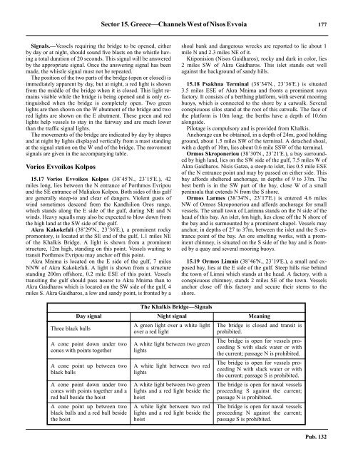
Sector 15. Greece—Channels West of Nisos Evvoia 17715.16 Signals.—Vessels requiring the bridge to be opened, eitherby day or at night, should sound five blasts on the whistle havinga total duration of 20 seconds. This signal will be answeredby the appropriate signal. Once the answering signal has beenmade, the whistle signal must not be repeated.15.16 The position of the two parts of the bridge (open or closed) isimmediately apparent by day, but at night, a red light is shownfrom the middle of the bridge when it is closed. This light remainsvisible while the bridge is being opened and is only extinguishedwhen the bridge is completely open. Two greenlights are then shown on the W abutment of the bridge and twored lights are shown on the E abutment. These green and redlights help vessels to stay in the fairway and are much lowerthan the traffic signal lights.15.16 The movements of the bridge are indicated by day by shapesand at night by lights displayed vertically from a mast standingat the signal station on the W end of the bridge. The movementsignals are given in the accompanying table.Vorios Evvoikos Kolpos15.17 Vorios Evvoikos Kolpos (38˚45'N., 23˚15'E.), 42miles long, lies between the N entrance of Porthmos Evripouand the SE entrance of Maliakos Kolpos. Both sides of this gulfare generally steep-to and clear of dangers. Violent gusts ofwind sometimes descend from the Kandhilion Oros range,which stands along the E side of the gulf, during NE and Nwinds. Heavy squalls may also be expected to blow down fromthe high land at the SW side of the gulf.15.17 Akra Kakokefali (38˚29'N., 23˚36'E.), a prominent rockypromontory, is located at the SE end of the gulf, 1.1 miles NEof the Khalkis Bridge. A light is shown from a prominentstructure, 12m high, standing on this point. Vessels waiting totransit Porthmos Evripou may anchor off this point.15.17 Akra Mnima is located on the E side of the gulf, 7 milesNNW of Akra Kakokefali. A light is shown from a structurestanding 200m offshore, 0.2 mile ESE of this point. Vesselstransiting the gulf should pass nearer to Akra Mnima than toAkra Gaidharos which is located on the SW side of the gulf, 4miles S. Akra Gaidharos, a low and sandy point, is fronted by ashoal bank and dangerous wrecks are reported to lie about 1mile N and 2.3 miles NE of it.15.17 Ktiponision (Nisos Gaidharos), rocky and dark in color, lies2 miles SW of Akra Gaidharos. This islet stands out wellagainst the background of sandy hills.15.18 Psakhna Terminal (38˚34'N., 23˚36'E.) is situated3.5 miles ESE of Akra Mnima and fronts a prominent soyafactory. It consists of a berthing platform, with several mooringbuoys, which is connected to the shore by a catwalk. Severalconspicuous silos stand at the root of this catwalk. The face ofthe platform is 10m long; the berths have a depth of 10.6malongside.15.18 Pilotage is compulsory and is provided from Khalkis.15.18 Anchorage can be obtained, in a depth of 24m, good holdingground, about 1.5 miles SW of the terminal. A detached shoal,with a depth of 10m, lies about 0.6 mile SSW of the terminal.15.18 Ormos Skroponeriou (38˚30'N., 23˚21'E.), a bay surroundedby high land, lies on the SW side of the gulf, 7.5 miles W ofAkra Gaidharos. Nisis Gatza, a steep-to islet, lies 0.5 mile ESEof the N entrance point and may by passed on either side. Thisbay affords sheltered anchorage, in depths of 9 to 37m. Thebest berth is in the SW part of the bay, close W of a smallpeninsula that extends N from the S shore.15.18 Ormos Larmes (38˚34'N., 23˚17'E.) is entered 4.6 milesNW of Ormos Skroponeriou and affords anchorage for smallvessels. The small town of Larimna stands on the N side of thehead of this bay. An islet, 6m high, lies close off the N shore ofthe bay and is surmounted by a prominent chapel. Vessels mayanchor, in depths of 27 to 37m, between the islet and the S entrancepoint of the bay. An ore smelting works, with a prominentchimney, is situated on the S side of the bay and is frontedby a quay and several mooring buoys.15.19 Ormos Limnis (38˚46'N., 23˚19'E.), a small and exposedbay, lies at the E side of the gulf. Steep hills rise behindthe town of Limni which stands at the head. A factory, with aconspicuous chimney, stands 2 miles SE of the town. Vesselsanchor close off this factory and secure their sterns to theshore.Three black ballsThe Khalkis Bridge—SignalsDay signal Night signal MeaningA cone point down under twocones with points togetherA cone point up between twoblack ballsA cone point down under twocones with points together and ared ball beside the hoistA cone point up between twoblack balls and a red ball besidethe hoistA green light over a white lightover a red lightA white light between two greenlightsA white light between two redlightsA white light between two greenlights and a red light beside thehoistA white light between two redlights and a red light beside thehoistThe bridge is closed and transit isprohibited.The bridge is open for vessels proceedingS with slack water or withthe current; passage N is prohibited.The bridge is open for vessels proceedingN with slack water or withthe current; passage S is prohibited.The bridge is open for naval vesselsproceeding S against the current;passage N is prohibited.The bridge is open for naval vesselsproceeding N against the current;passage S is prohibited.Pub. 132
- Page 1 and 2:
PUB.132SAILING DIRECTIONS(ENROUTE)
- Page 3 and 4:
Preface0.0 Pub. 132, Sailing Direct
- Page 5 and 6:
ContentsHow to Keep this Book Corre
- Page 7 and 8:
0.0SECTOR LIMITS—PUB. 132Pub. 132
- Page 9:
AbbreviationsThe following abbrevia
- Page 13 and 14:
3SECTOR 1COAST OF LIBYA1.0 Plan.—
- Page 15 and 16:
Sector1.CoastofLibya 51.5 Pilotage.
- Page 17 and 18:
Sector1.CoastofLibya 71.12 Caution.
- Page 19 and 20:
Sector1.CoastofLibya 91.17 Jabal La
- Page 21 and 22:
Sector1.CoastofLibya 111.21 Tukrah
- Page 23:
Sector1.CoastofLibya 131.28 Aspect.
- Page 27 and 28:
17SECTOR 2COAST OF EGYPT2.0 Plan.
- Page 29 and 30:
Sector2.CoastofEgypt 19a depth of 2
- Page 31 and 32:
Sector2.CoastofEgypt 212.10 Several
- Page 33 and 34:
Sector2.CoastofEgypt 232.17 Local v
- Page 35:
Sector2.CoastofEgypt 25high, stands
- Page 39 and 40:
29SECTOR 3COASTS OF ISRAEL, LEBANON
- Page 41 and 42:
Sector 3. Coasts of Israel, Lebanon
- Page 43 and 44:
Sector 3. Coasts of Israel, Lebanon
- Page 45 and 46:
Sector 3. Coasts of Israel, Lebanon
- Page 47 and 48:
Sector 3. Coasts of Israel, Lebanon
- Page 49:
4.CyprusPub. 1324.0Additional chart
- Page 52 and 53:
42 Sector4.Cyprusthe village. Ancho
- Page 54 and 55:
44 Sector4.Cyprus4.10 A conspicuous
- Page 56 and 57:
46 Sector4.Cyprus4.18 Kakoskaliou I
- Page 59 and 60:
49SECTOR 5SOUTH COAST OF TURKEY—K
- Page 61 and 62:
Sector 5. South Coast of Turkey—K
- Page 63 and 64:
Sector 5. South Coast of Turkey—K
- Page 65 and 66:
Sector 5. South Coast of Turkey—K
- Page 67:
Sector 5. South Coast of Turkey—K
- Page 71 and 72:
61SECTOR 6RODHOS (RHODES), NISOS KA
- Page 73 and 74:
Sector 6. Rodhos (Rhodes), Nisos Ka
- Page 75 and 76:
Sector 6. Rodhos (Rhodes), Nisos Ka
- Page 77 and 78:
Sector 6. Rodhos (Rhodes), Nisos Ka
- Page 79 and 80:
Sector 6. Rodhos (Rhodes), Nisos Ka
- Page 81 and 82:
Sector 6. Rodhos (Rhodes), Nisos Ka
- Page 83:
7.West Coast of Greece and Dhiorix
- Page 86 and 87:
76 Sector 7. West Coast of Greece a
- Page 88 and 89:
78 Sector 7. West Coast of Greece a
- Page 90 and 91:
80 Sector 7. West Coast of Greece a
- Page 93:
8.West Coasts of Greece and Albania
- Page 96 and 97:
86 Sector 8. West Coasts of Greece
- Page 98 and 99:
88 Sector 8. West Coasts of Greece
- Page 100 and 101:
90 Sector 8. West Coasts of Greece
- Page 102 and 103:
92 Sector 8. West Coasts of Greece
- Page 105:
9.Coasts of Albania, Montenegro, an
- Page 108 and 109:
98 Sector 9. Coasts of Albania, Mon
- Page 110 and 111:
100 Sector 9. Coasts of Albania, Mo
- Page 112 and 113:
102 Sector 9. Coasts of Albania, Mo
- Page 114 and 115:
104 Sector 9. Coasts of Albania, Mo
- Page 117:
10.Coasts of Croatia and Bosnia-Her
- Page 120 and 121:
110 Sector 10. Coasts of Croatia an
- Page 122 and 123:
112 Sector 10. Coasts of Croatia an
- Page 124 and 125:
114 Sector 10. Coasts of Croatia an
- Page 126 and 127:
116 Sector 10. Coasts of Croatia an
- Page 128 and 129:
118 Sector 10. Coasts of Croatia an
- Page 131 and 132:
121SECTOR 11COAST OF CROATIA—RT M
- Page 133 and 134:
Sector 11. Coast of Croatia—Rt Mo
- Page 135 and 136: Sector 11. Coast of Croatia—Rt Mo
- Page 137 and 138: Sector 11. Coast of Croatia—Rt Mo
- Page 139 and 140: Sector 11. Coast of Croatia—Rt Mo
- Page 141 and 142: Sector 11. Coast of Croatia—Rt Mo
- Page 143: Sector 11. Coast of Croatia—Rt Mo
- Page 147 and 148: 137SECTOR 12COAST OF GREECE—AKRA
- Page 149 and 150: Sector 12. Coast of Greece—Akra T
- Page 151 and 152: Sector 12. Coast of Greece—Akra T
- Page 153 and 154: Sector 12. Coast of Greece—Akra T
- Page 155: 13.Coast of Greece—Saronikos Kolp
- Page 158 and 159: 148 Sector 13. Coast of Greece—Sa
- Page 160 and 161: 150 Sector 13. Coast of Greece—Sa
- Page 162 and 163: 152 Sector 13. Coast of Greece—Sa
- Page 164 and 165: 154 Sector 13. Coast of Greece—Sa
- Page 167: 14.Greece—Kikladhes Nisoi15714.0A
- Page 170 and 171: 160 Sector14.Greece—KikladhesNiso
- Page 172 and 173: 162 Sector14.Greece—KikladhesNiso
- Page 174 and 175: 164 Sector14.Greece—KikladhesNiso
- Page 176 and 177: 166 Sector14.Greece—KikladhesNiso
- Page 178 and 179: 168 Sector14.Greece—KikladhesNiso
- Page 181: 15.Greece—Channels West of Nisos
- Page 184 and 185: 174 Sector 15. Greece—Channels We
- Page 188 and 189: 178 Sector 15. Greece—Channels We
- Page 191: 16.Greece—Nisoi Vorioi Sporadhes
- Page 194 and 195: 184 Sector 16. Greece—Nisoi Vorio
- Page 196 and 197: 186 Sector 16. Greece—Nisoi Vorio
- Page 199: 17.Coast of Greece—Thermaikos Kol
- Page 202 and 203: 192 Sector 17. Coast of Greece—Th
- Page 204 and 205: 194 Sector 17. Coast of Greece—Th
- Page 206 and 207: 196 Sector 17. Coast of Greece—Th
- Page 209: 18.Greece—Dhodhekanisos and South
- Page 212 and 213: 202 Sector 18. Greece—Dhodhekanis
- Page 214 and 215: 204 Sector 18. Greece—Dhodhekanis
- Page 216 and 217: 206 Sector 18. Greece—Dhodhekanis
- Page 219: 19.West Coast of Turkey—Samos Str
- Page 222 and 223: 212 Sector 19. West Coast of Turkey
- Page 224 and 225: 214 Sector 19. West Coast of Turkey
- Page 226 and 227: 216 Sector 19. West Coast of Turkey
- Page 229: 20.The Dardanelles Approach and Adj
- Page 232 and 233: 222 Sector 20. The Dardanelles Appr
- Page 234 and 235: 224 Sector 20. The Dardanelles Appr
- Page 236 and 237:
226 Sector 20. The Dardanelles Appr
- Page 238 and 239:
228 Sector 20. The Dardanelles Appr
- Page 240 and 241:
230 GlossariesArabicARABICEnglishAR
- Page 242 and 243:
232 GlossariesARABICEnglishARABICEn
- Page 244 and 245:
234 GlossariesHebrewHEBREWEnglishHE
- Page 246 and 247:
236 GlossariesTURKISHEnglishTURKISH
- Page 249 and 250:
How to use the Index—Gazetteer239
- Page 251 and 252:
Index—Gazetteer 241PositionSec.˚
- Page 253 and 254:
Index—Gazetteer 243PositionSec.˚
- Page 255 and 256:
Index—Gazetteer 245PositionSec.˚
- Page 257 and 258:
Index—Gazetteer 247PositionSec.˚