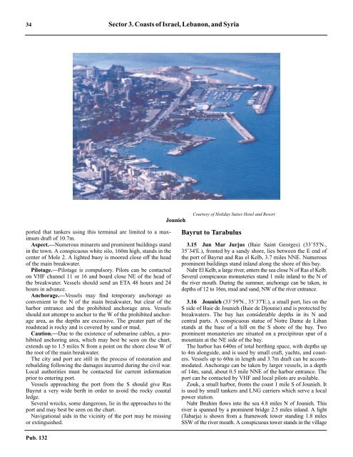
34 Sector 3. Coasts of Israel, Lebanon, and Syriaported that tankers using this terminal are limited to a maximumdraft of 10.7m.3.14 Aspect.—Numerous minarets and prominent buildings standin the town. A conspicuous white silo, 160m high, stands in thecenter of Mole 2. A lighted buoy is moored close off the headof the main breakwater.3.14 Pilotage.—Pilotage is compulsory. Pilots can be contactedon VHF channel 11 or 16 and board close NE of the head ofthe breakwater. Vessels should send an ETA 48 hours and 24hours in advance.3.14 Anchorage.—Vessels may find temporary anchorage asconvenient to the N of the main breakwater, but clear of theharbor entrance and the prohibited anchorage area. Vesselsshould not attempt to anchor to the W of the prohibited anchoragearea, as the depths are excessive. The greater part of theroadstead is rocky and is covered by sand or mud.3.14 Caution.—Due to the existence of submarine cables, a prohibitedanchoring area, which may best be seen on the chart,extends up to 1.5 miles N from a point on the shore close W ofthe root of the main breakwater.3.14 The city and port are still in the process of restoration andrebuilding following the damages incurred during the civil war.Local authorities must be contacted for current informationprior to entering port.3.14 Vessels approaching the port from the S should give RasBayrut a very wide berth in order to avoid the rocky coastalledge.3.14 Several wrecks, some dangerous, lie in the approaches to theport and may best be seen on the chart.3.14 Navigational aids in the vicinity of the port may be missingor extinguished.Pub. 132JouniehCourtesy of Holiday Suites Hotel and ResortBayrut to Tarabulus3.15 Jun Mar Jurjus (Baie Saint Georges) (33˚55'N.,35˚34'E.), fronted by a sandy shore, lies between the E end ofthe port of Bayrut and Ras el Kelb, 3.7 miles NNE. Numerousprominent buildings stand inland along the shore of this bay.3.15 Nahr El Kelb, a large river, enters the sea close N of Ras el Kelb.Several conspicuous monasteries stand 1 mile inland to the N ofthe river mouth. During the summer, anchorage can be taken, indepths of 12 to 16m, mud and sand, NW of the river entrance.3.16 Jounieh (33˚59'N., 35˚37'E.), a small port, lies on theS side of Baie de Jounieh (Baie de Djounie) and is protected bybreakwaters. The bay has considerable depths in its N andcentral parts. A conspicuous statue of Notre Dame de Libanstands at the base of a hill on the S shore of the bay. Twoprominent monasteries are situated on a precipitous spur of amountain at the NE side of the bay.3.16 The harbor has 640m of total berthing space, with depths upto 4m alongside, and is used by small craft, yachts, and coasters.Vessels up to 60m in length and 3.7m draft can be accommodated.Anchorage can be taken by larger vessels, in a depthof 14m, sand, about 0.5 mile NNE of the harbor entrance. Theport can be contacted by VHF and local pilots are available.3.16 Zouk, a small harbor, fronts the coast 1 mile S of Jounieh. Itis used by small tankers and LNG carriers which serve a localpower station.3.16 Nahr Ibrahim flows into the sea 4.8 miles N of Jounieh. Thisriver is spanned by a prominent bridge 2.5 miles inland. A light(Tabarja) is shown from a framework tower standing 1.8 milesSSW of the river mouth. A conspicuous tower stands in the village
Sector 3. Coasts of Israel, Lebanon, and Syria 35Tarabulus (Tripoli) from NWof Jubayl (Jebail), 3.5 miles N of the river mouth. A light is shownfrom Ras Aamchite (Ras Amshit), 2 miles NNE of Jubayl.3.16 Ras Selata, a steep-to point, is located 9.5 miles N of Jubayland is surmounted by a prominent tower.3.16 Selaata (34˚16'N., 35˚39'E.), a small port, lies in the vicinityof the point and is protected by a breakwater. The harbor canbe contacted on VHF channel 16 and a local pilot is availableand will board about 0.5 mile N of the entrance. The harbor hasone main commercial quay, with a depth of 14m alongside,which can accommodate vessels up to 70,000 dwt, 230m inlength, and 13m draft.3.17 Ras Shikka (Cape Madona) (34˚19'N., 35˚41'E.),located 2.3 miles NE of Ras Selata, is the W termination of atableland, 233m high. The cape is surmounted by a chapel onits NW edge and the sides are precipitous and wooded.3.17 Al Huri, a small and open bay, is entered between RasShikka and Ras an Natur, 4.5 miles NE. A conspicuous largesquare building stands on the latter point and is a good landmarkfrom seaward.3.17 A conspicuous chimney, illuminated at night, stands in thevillage of Shikka Atiqah which is situated about midwaybetween the entrance points. By day, a dense cloud of whitesmoke rises from this chimney and is visible for a considerabledistance offshore. A light is shown from a structure standing onthe coast in the SW part of the village. A jetty, 40m long, frontsthe shore close N of the light. Vessels with drafts up to 8.1mcan berth at the head of this jetty with the use of mooringbuoys. Anchorage can be taken, in a depth of 16m, sand, in theS part of the bay.3.17 The village of Anfah (Enfe) is situated in the N part of thebay and is marked by a light. A ridge of rocks fronts the villageand extends up to 1 mile seaward.3.17 Al Mina (34˚27'N., 35˚48'E.), formed by a low promontory, islocated 6 miles NE of Ras an Natur at the W side of Tarabulus.The coast between is fronted by rocks and shoals which extend upto about 1 mile, in places, from the shore. A conspicuous conventstands on a hill, 4.2 miles SSW of Al Mina.3.17 Jazirat Ramkin (34˚30'N., 35˚45'E.) is the outermost of achain of islets, rocks, and shoals which extends up to 3.8 milesNW of Al Mina. A main light is shown from a structure, 5mhigh, standing at the W side of this islet.3.17 Sanani Channel, with a depth of 11m, leads through thischain of dangers 2 miles NW of Al Mina. This passage has afairway 0.3 mile wide, is unmarked, and is only used by smallvessels with local knowledge.Tarabulus (Tripoli) (34˚27'N., 35˚50'E.)World Port Index No. 450253.18 Tarabulus (Tripoli), a large city, extends E of Al Minaand contains numerous high-rise buildings. The port complexfronts the N shore of the city and consists of a harbor basin,protected by a breakwaters at the W end, and an offshoretanker terminal at the E end. Deep-draft vessels frequentlytransfer cargo to lighters in the roadstead close N of the harborbasin.3.18 Winds—Weather.—Port operations in the roadstead areusually suspended for up to 20 days from December throughMarch as a result of N gales. During the rainy season (Januaryand February), periods of intermittent rain may last up to 11days.3.18 Tides—Currents.—The tidal rise is very small, being only0.6m at springs.3.18 Tidal currents are weak and variable and are often hidden bysurface currents generated by the wind.3.18 Depths—Limitations.—The entrance fairway is about150m wide and has a dredged depth of 9m. A pier, 600m long,has two berths on its W side with depths of 8 to 10m alongside.Vessels up to 150m in length and 6.8m draft can be accommodatedalongside.3.18 The oil terminal has five offshore loading berths which lie indepths of 11.6 to 20.1m. The berths consist of several mooringbuoys and are connected to the shore by submarine pipelines.Berth No. 5 can handle tankers up to 35,000 dwt with a maximumdraft of 7.5m draft; Berth No. 4 can handle tankers up to25,000 dwt and 9.7m draft; Berth No. 3 can handle tankers upto 87,000 dwt and 14.3m draft; Berth No. 2 can handle tankersup to 250,000 dwt and 18.3m draft; and Berth No. 1 can handletankers up to 140,000 dwt and 17m draft.Pub. 132
- Page 1 and 2: PUB.132SAILING DIRECTIONS(ENROUTE)
- Page 3 and 4: Preface0.0 Pub. 132, Sailing Direct
- Page 5 and 6: ContentsHow to Keep this Book Corre
- Page 7 and 8: 0.0SECTOR LIMITS—PUB. 132Pub. 132
- Page 9: AbbreviationsThe following abbrevia
- Page 13 and 14: 3SECTOR 1COAST OF LIBYA1.0 Plan.—
- Page 15 and 16: Sector1.CoastofLibya 51.5 Pilotage.
- Page 17 and 18: Sector1.CoastofLibya 71.12 Caution.
- Page 19 and 20: Sector1.CoastofLibya 91.17 Jabal La
- Page 21 and 22: Sector1.CoastofLibya 111.21 Tukrah
- Page 23: Sector1.CoastofLibya 131.28 Aspect.
- Page 27 and 28: 17SECTOR 2COAST OF EGYPT2.0 Plan.
- Page 29 and 30: Sector2.CoastofEgypt 19a depth of 2
- Page 31 and 32: Sector2.CoastofEgypt 212.10 Several
- Page 33 and 34: Sector2.CoastofEgypt 232.17 Local v
- Page 35: Sector2.CoastofEgypt 25high, stands
- Page 39 and 40: 29SECTOR 3COASTS OF ISRAEL, LEBANON
- Page 41 and 42: Sector 3. Coasts of Israel, Lebanon
- Page 43: Sector 3. Coasts of Israel, Lebanon
- Page 47 and 48: Sector 3. Coasts of Israel, Lebanon
- Page 49: 4.CyprusPub. 1324.0Additional chart
- Page 52 and 53: 42 Sector4.Cyprusthe village. Ancho
- Page 54 and 55: 44 Sector4.Cyprus4.10 A conspicuous
- Page 56 and 57: 46 Sector4.Cyprus4.18 Kakoskaliou I
- Page 59 and 60: 49SECTOR 5SOUTH COAST OF TURKEY—K
- Page 61 and 62: Sector 5. South Coast of Turkey—K
- Page 63 and 64: Sector 5. South Coast of Turkey—K
- Page 65 and 66: Sector 5. South Coast of Turkey—K
- Page 67: Sector 5. South Coast of Turkey—K
- Page 71 and 72: 61SECTOR 6RODHOS (RHODES), NISOS KA
- Page 73 and 74: Sector 6. Rodhos (Rhodes), Nisos Ka
- Page 75 and 76: Sector 6. Rodhos (Rhodes), Nisos Ka
- Page 77 and 78: Sector 6. Rodhos (Rhodes), Nisos Ka
- Page 79 and 80: Sector 6. Rodhos (Rhodes), Nisos Ka
- Page 81 and 82: Sector 6. Rodhos (Rhodes), Nisos Ka
- Page 83: 7.West Coast of Greece and Dhiorix
- Page 86 and 87: 76 Sector 7. West Coast of Greece a
- Page 88 and 89: 78 Sector 7. West Coast of Greece a
- Page 90 and 91: 80 Sector 7. West Coast of Greece a
- Page 93: 8.West Coasts of Greece and Albania
- Page 96 and 97:
86 Sector 8. West Coasts of Greece
- Page 98 and 99:
88 Sector 8. West Coasts of Greece
- Page 100 and 101:
90 Sector 8. West Coasts of Greece
- Page 102 and 103:
92 Sector 8. West Coasts of Greece
- Page 105:
9.Coasts of Albania, Montenegro, an
- Page 108 and 109:
98 Sector 9. Coasts of Albania, Mon
- Page 110 and 111:
100 Sector 9. Coasts of Albania, Mo
- Page 112 and 113:
102 Sector 9. Coasts of Albania, Mo
- Page 114 and 115:
104 Sector 9. Coasts of Albania, Mo
- Page 117:
10.Coasts of Croatia and Bosnia-Her
- Page 120 and 121:
110 Sector 10. Coasts of Croatia an
- Page 122 and 123:
112 Sector 10. Coasts of Croatia an
- Page 124 and 125:
114 Sector 10. Coasts of Croatia an
- Page 126 and 127:
116 Sector 10. Coasts of Croatia an
- Page 128 and 129:
118 Sector 10. Coasts of Croatia an
- Page 131 and 132:
121SECTOR 11COAST OF CROATIA—RT M
- Page 133 and 134:
Sector 11. Coast of Croatia—Rt Mo
- Page 135 and 136:
Sector 11. Coast of Croatia—Rt Mo
- Page 137 and 138:
Sector 11. Coast of Croatia—Rt Mo
- Page 139 and 140:
Sector 11. Coast of Croatia—Rt Mo
- Page 141 and 142:
Sector 11. Coast of Croatia—Rt Mo
- Page 143:
Sector 11. Coast of Croatia—Rt Mo
- Page 147 and 148:
137SECTOR 12COAST OF GREECE—AKRA
- Page 149 and 150:
Sector 12. Coast of Greece—Akra T
- Page 151 and 152:
Sector 12. Coast of Greece—Akra T
- Page 153 and 154:
Sector 12. Coast of Greece—Akra T
- Page 155:
13.Coast of Greece—Saronikos Kolp
- Page 158 and 159:
148 Sector 13. Coast of Greece—Sa
- Page 160 and 161:
150 Sector 13. Coast of Greece—Sa
- Page 162 and 163:
152 Sector 13. Coast of Greece—Sa
- Page 164 and 165:
154 Sector 13. Coast of Greece—Sa
- Page 167:
14.Greece—Kikladhes Nisoi15714.0A
- Page 170 and 171:
160 Sector14.Greece—KikladhesNiso
- Page 172 and 173:
162 Sector14.Greece—KikladhesNiso
- Page 174 and 175:
164 Sector14.Greece—KikladhesNiso
- Page 176 and 177:
166 Sector14.Greece—KikladhesNiso
- Page 178 and 179:
168 Sector14.Greece—KikladhesNiso
- Page 181:
15.Greece—Channels West of Nisos
- Page 184 and 185:
174 Sector 15. Greece—Channels We
- Page 186 and 187:
176 Sector 15. Greece—Channels We
- Page 188 and 189:
178 Sector 15. Greece—Channels We
- Page 191:
16.Greece—Nisoi Vorioi Sporadhes
- Page 194 and 195:
184 Sector 16. Greece—Nisoi Vorio
- Page 196 and 197:
186 Sector 16. Greece—Nisoi Vorio
- Page 199:
17.Coast of Greece—Thermaikos Kol
- Page 202 and 203:
192 Sector 17. Coast of Greece—Th
- Page 204 and 205:
194 Sector 17. Coast of Greece—Th
- Page 206 and 207:
196 Sector 17. Coast of Greece—Th
- Page 209:
18.Greece—Dhodhekanisos and South
- Page 212 and 213:
202 Sector 18. Greece—Dhodhekanis
- Page 214 and 215:
204 Sector 18. Greece—Dhodhekanis
- Page 216 and 217:
206 Sector 18. Greece—Dhodhekanis
- Page 219:
19.West Coast of Turkey—Samos Str
- Page 222 and 223:
212 Sector 19. West Coast of Turkey
- Page 224 and 225:
214 Sector 19. West Coast of Turkey
- Page 226 and 227:
216 Sector 19. West Coast of Turkey
- Page 229:
20.The Dardanelles Approach and Adj
- Page 232 and 233:
222 Sector 20. The Dardanelles Appr
- Page 234 and 235:
224 Sector 20. The Dardanelles Appr
- Page 236 and 237:
226 Sector 20. The Dardanelles Appr
- Page 238 and 239:
228 Sector 20. The Dardanelles Appr
- Page 240 and 241:
230 GlossariesArabicARABICEnglishAR
- Page 242 and 243:
232 GlossariesARABICEnglishARABICEn
- Page 244 and 245:
234 GlossariesHebrewHEBREWEnglishHE
- Page 246 and 247:
236 GlossariesTURKISHEnglishTURKISH
- Page 249 and 250:
How to use the Index—Gazetteer239
- Page 251 and 252:
Index—Gazetteer 241PositionSec.˚
- Page 253 and 254:
Index—Gazetteer 243PositionSec.˚
- Page 255 and 256:
Index—Gazetteer 245PositionSec.˚
- Page 257 and 258:
Index—Gazetteer 247PositionSec.˚