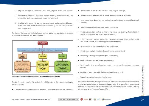
comprises specialised trade, such as restaurants, as well as convenience stores/ facilities(corner shop, pharmacy) for <strong>the</strong> surrounding residential area. At <strong>the</strong> suburban scale <strong>the</strong>mixed use is structured around a major traffic route with supporting public transport facilities.close proximity to <strong>the</strong> industrial activity. O<strong>the</strong>r areas may be developed over time, as <strong>the</strong>urban system grows and expands; and certain of <strong>the</strong> activities may be re-located and/ordiscontinued, creating opportunities for new <strong>development</strong>.ANNEXURE A: THE 5 GIS-BASED MODELSDISTRICTSDistricts are larger neighbourhood segments of <strong>the</strong> city that comprise in many instancesmono-use areas between urban structure elements. These could be, for example, suburbanneighbourhoods located between activity spines and/or around nodes, with neighbourhoodfacilities such as schools and local high streets providing convenience retail and local businesssupport. O<strong>the</strong>r examples would be significantly sized recreational areas and sports grounds.Districts could also be specialist industrial areas. The districts are neighbourhood orientated,and are edged by urban structure elements such as an activity spine, node and corridor.Where <strong>the</strong> district is not contained by an urban structure element, but forms a vast expanseof land area, such as areas of agricultural small-holdings and areas on <strong>the</strong> urban fringe withlow-intensity mining, quarrying and agricultural activity, an interstitial zone is formed.NATURAL SYSTEMSThe natural systems include <strong>the</strong> ecosystems within <strong>the</strong> urban area, <strong>the</strong> natural environmentand its distinguishing features. These typically include ridges and rivers, associated wetlandsand <strong>the</strong> all-important grasslands. They include nature areas, conservation areas and naturalhabitat which must ei<strong>the</strong>r be rehabilitated and/or expanded. The inclusion of ecosystemswithin <strong>the</strong> natural systems 'morphological type' ensures that a sustain- able approach isincorporated within urban <strong>development</strong>, and that <strong>the</strong> natural environment forms an integralpart of <strong>the</strong> urban environment.URBAN VOIDSThe urban void comprises expansive areas (or discontinuities) within <strong>the</strong> urban system thatremain or are under- and/or un- developed for very specific reasons. These typically includeextensive agricultural holdings and mining areas, as well as land used for military purposes.Some areas remain undeveloped due to <strong>the</strong>ir potential threat to human safety and health,for example unstable geotechnical conditions due to <strong>the</strong> formation of sink holes and previousmining activity, and industrial activity/ production which prohibits urban <strong>development</strong> inMODELLING THE QUANTIFIABLE ASPECTS OF URBAN STRUCTUREELEMENTS AS A BROAD BASELINE OF POTENTIAL PERFORMANCEA <strong>spatial</strong>/ physical and associated quantitative assessment of <strong>the</strong> elements is established,based on a combination of current precedent, urban <strong>development</strong> principles and generallyaccepted urban design standards. This establishes, in broad terms, <strong>the</strong> performance ofeach of <strong>the</strong> morphological types, and forms <strong>the</strong> basis that determines <strong>the</strong> general level offunction to which <strong>the</strong>y are expected to perform. When measured against <strong>the</strong> existingperformance, <strong>the</strong> difference from <strong>the</strong> potential performance highlights <strong>the</strong> urban potentialthat each urban morphological type carries, and what might be expected in urban achievementterms and how decisions may be made/ undertaken with regard to fur<strong>the</strong>r allocation ofmixed-use <strong>development</strong>, residential growth, public transport, service and social infrastructureinvestments.This is based on <strong>the</strong> knowledge of city building and <strong>the</strong> <strong>development</strong> of urban systems thatcertain urban fundamentals, informed by socio-economic systems, ascribe a certain urbanor land value to areas within <strong>the</strong> urban system. These values differ across <strong>the</strong> urban system,are high and occur in concentrations in some areas and are low and more dispersed in o<strong>the</strong>rareas. These values both inform and respond to urban infrastructure <strong>development</strong> interventions,as well as built form <strong>development</strong>, which shape, form and determine <strong>the</strong> nature of <strong>the</strong>urban environment. As a consequence of <strong>the</strong>se inherent logics, including where peoplechoose to be and in what numbers , and how <strong>the</strong>se logics ei<strong>the</strong>r support <strong>the</strong> human activityor constrain it, <strong>the</strong> associated activity patterns and land uses become a resultant expressionof <strong>the</strong> urban structure.The urban morphological model <strong>the</strong>refore focuses, as a first step, on describing what exists,and on benchmarking <strong>the</strong> urban performance of each of <strong>the</strong> urban structure elements. Bymodelling each of <strong>the</strong> key components of <strong>the</strong> morphological types, <strong>the</strong> typical characteristics ofeach type are established. Each of <strong>the</strong> morphological types has three dimensions (Figure A.2.4):89 GAUTENG SPATIAL DEVELOPMENT FRAMEWORK 2011 GAUTENG GROWTH AND DEVELOPMENT AGENCY
i. Physical and Spatial Dimension: Built form, physical extent and location.• Development intensity - higher floor areas, higher coverage;ii.iii.Quantitative Dimension: Population, residential density, land and floor area, landuse activity, facilities/ services, open space and o<strong>the</strong>r; andQualitative Dimension: Urban management, safety and security, public openspace, basic needs/ health, social support/ community, access/ transportation,and employment.• Located at most connected and accessible points within <strong>the</strong> urban system;• Form economic and employment centres (include business, commercial and retailactivities);• Have logistics and freight transport support and access;The focus of <strong>the</strong> urban morphological model is on <strong>the</strong> <strong>spatial</strong> and quantitative dimensions,as <strong>the</strong>se are incorporated into <strong>the</strong> GIS system.• Mixed use activities - vertical and horizontal mixed use, diversity of activities thatreinforce one ano<strong>the</strong>r and form a mixed economy;• Public transport supported/ driven (reduced car dependency, environmentaland health benefits, even reducing parking requirements);• Higher residential densities and mix of residential types;• Streets have multiple functions (beyond mere vehicle conduits);• Walkability, with supporting public space environment;• Predicated on a street grid system, most efficient;Figure A.2.4: Modelling key components of Urban Morphological Types.The <strong>development</strong> principles that underlie <strong>the</strong> establishment of <strong>the</strong> urban morphologicalelements include:• Concentration/ agglomeration of activities - economies of scale and efficiency;• Sustainability in terms of environmental respect, social needs and economicviability;• Provision of supporting public facilities and social services; and• Supporting engineering services (capital web).The consolidation of <strong>the</strong> <strong>development</strong> principles forms a baseline to establish <strong>the</strong> potentialphysical and <strong>spatial</strong> extent, and associated quantitative dimension of <strong>the</strong> morphologicalelements. Collectively <strong>the</strong>se identify <strong>the</strong> typical performance of an element. The key'performance factors' include (Figure A.2.5):ANNEXURE A: THE 5 GIS-BASED MODELSGAUTENG SPATIAL DEVELOPMENT FRAMEWORK 2011GAUTENG GROWTH AND DEVELOPMENT AGENCY90
- Page 1:
THE GAUTENG SPATIAL DEVELOPMENT FRA
- Page 4 and 5:
TABLE OF CONTENTSSECTION 1: INTRODU
- Page 6 and 7:
Table A.2-iv: Summary - Typical per
- Page 8 and 9:
FIGURESSECTION 1: INTRODUCTIONFigur
- Page 10 and 11:
Figure A.2.4: Modelling key compone
- Page 12 and 13:
FOREWORD
- Page 14 and 15:
SECTION1:Introduction
- Page 16 and 17:
development framework around which
- Page 18 and 19:
SECTION 1: INTRODUCTIONcadastral in
- Page 20 and 21:
Not only does it seem necessary to
- Page 22 and 23:
SECTION 2: THE GSDF AS A CONCEPTA S
- Page 24 and 25:
disasters, shortages and changes in
- Page 26 and 27:
are to promote sustainability, equi
- Page 28 and 29:
It is legislated that metropolitan
- Page 30 and 31:
Similarly, there must be a consiste
- Page 32 and 33:
The corridors reflected in the figu
- Page 34 and 35:
Similarly, in the United Kingdom, i
- Page 36 and 37:
• urban compactness, also noted i
- Page 38 and 39:
With Johannesburg as the city syste
- Page 40 and 41:
Making sense of, and integrating, t
- Page 42 and 43:
Based on this figure, it is suggest
- Page 44 and 45:
On this basis, there is no reason w
- Page 46 and 47:
SECTION 2: THE GSDF AS A CONCEPTPRI
- Page 48 and 49:
SECTION 2: THE GSDF AS A CONCEPTPRI
- Page 50 and 51:
SECTION3:The modelling elements of
- Page 52 and 53: value that goes with this can be de
- Page 54 and 55: THE MODELLING THAT UNDERPINS THE GS
- Page 56 and 57: MODEL 2: THE MORPHOLOGICAL MODELaro
- Page 58 and 59: with lower levels of accessibility.
- Page 60 and 61: MODEL 5: THE VIRTUAL MODEL ROOMSECT
- Page 62 and 63: URBAN MANAGEMENT AND SPATIAL DEVELO
- Page 64 and 65: making processes around these (for
- Page 66 and 67: The intricacies of the urban struct
- Page 68 and 69: SECTION 4: OUTCOMES OF APPLICATION:
- Page 70 and 71: STEP SIX: URBAN DEVELOPMENT, MANAGE
- Page 72 and 73: THE COMPOSITE SPATIAL STRUCTUREThe
- Page 74 and 75: SECTION 4: OUTCOMES OF APPLICATION:
- Page 76 and 77: FRAMEWORK FOR THE IMPLEMENTATION OF
- Page 78 and 79: SECTION 5: FRAMEWORK FOR THE IMPLEM
- Page 80 and 81: TRANSPORTATIONThe principles of urb
- Page 82 and 83: URBAN STRUCTURING INITIATIVESSECTIO
- Page 84 and 85: SECTION 5: FRAMEWORK FOR THE IMPLEM
- Page 86 and 87: It is not enough, however, to simpl
- Page 88 and 89: APPENDIXA.1: The urban profile mode
- Page 90 and 91: ANNEXURE A: THE 5 GIS-BASED MODELSF
- Page 92 and 93: THE IDENTIFICATION OF MORPHOLOGICAL
- Page 94 and 95: ANNEXURE A: THE 5 GIS-BASED MODELSU
- Page 96 and 97: DEFINING THE MORPHOLOGICAL COMPONEN
- Page 98 and 99: • Activity Spines, with a hierarc
- Page 100 and 101: ANNEXURE A: THE 5 GIS-BASED MODELSN
- Page 104 and 105: • Development Intensity: Land are
- Page 106 and 107: THE REGIONAL NODEDevelopment Yield:
- Page 108 and 109: THE TYPICAL PERFORMANCE DIMENSION O
- Page 110 and 111: TYPICAL DEVELOPMENT PARAMETERS: URB
- Page 112 and 113: ANNEXURE A: THE 5 GIS-BASED MODELSF
- Page 114 and 115: ANNEXURE A: THE 5 GIS-BASED MODELSF
- Page 116 and 117: Figures A.2.13-15 show the same are
- Page 118 and 119: ANNEXURE A: THE 5 GIS-BASED MODELSF
- Page 120 and 121: THE CONNECTIVITY MODELANNEXURE A: T
- Page 122 and 123: CONNECTIVITY MODEL 2This iteration
- Page 124 and 125: CONNECTIVITY MODEL 4The fourth iter
- Page 126 and 127: CONNECTIVITY MODEL 6The final itera
- Page 128 and 129: THE BID-RENT MODELThe Bid-Rent Mode
- Page 130 and 131: TOPOGRAPHIC SUITABILITYThe Topograp
- Page 132 and 133: THE SPATIAL POLICY SUPPORT INDEXThe
- Page 134 and 135: SURFACE CONSTRAINTSThe Surface Cons
- Page 136 and 137: APPENDIXA.5Model 5 - the virtualmod
- Page 138 and 139: TSHWANE STATIONS123Existing conditi
- Page 140 and 141: APPENDIXB.1: Restrictingurban spraw
- Page 142 and 143: urban edge, many of the municipal S
- Page 144 and 145: ANNEXURE B: POLICY POSITION PAPERSF
- Page 146 and 147: APPENDIXB.2: A densification policy
- Page 148 and 149: The model that is to guide both res
- Page 150 and 151: APPENDIXB.3: Harmonisinghousingprov
- Page 152 and 153:
housing and mixed-uses can be reali
- Page 154 and 155:
ANNEXURE B: POLICY POSITION PAPERSF
- Page 156 and 157:
ANNEXURE B: POLICY POSITION PAPERSF
- Page 158 and 159:
THE PRINCIPLES GOVERNING THE TRANSP
- Page 160 and 161:
ANNEXURE B: POLICY POSITION PAPERSi
- Page 162 and 163:
Possible outer extentsof urban deve
- Page 164 and 165:
APPENDIXB.5: Thecase principles ofs
- Page 166 and 167:
sustainable and efficient. A long-t
- Page 168 and 169:
ANNEXURE B: POLICY POSITION PAPERSB
- Page 170 and 171:
APPENDIXC.1: Thefreight and logisti
- Page 172 and 173:
overall platform on which more focu
- Page 174 and 175:
A further south-eastern regional hu
- Page 176 and 177:
ANNEXURE C: POLICY PERSPECTIVESFigu
- Page 178 and 179:
APPENDIXC.2: A perspective guidingt
- Page 180 and 181:
anges of hills or mountains, whethe
- Page 182 and 183:
APPENDIXC.3: Preservationof landhav
- Page 184 and 185:
ANNEXURE C: POLICY PERSPECTIVESFigu
- Page 186 and 187:
URBAN CONSOLIDATION ZONESThe physic
- Page 188 and 189:
APPENDIXC.5: Indicativepatterns ofe
- Page 190 and 191:
ANNEXURE C: POLICY PERSPECTIVESFigu
- Page 192 and 193:
ANNEXURE C: POLICY PERSPECTIVESFigu
- Page 194 and 195:
APPENDIXC.6: Integrationof the rura
- Page 196 and 197:
opportunity that goes with being ab
- Page 198 and 199:
ANNEXURED: The package of plans
- Page 200 and 201:
In order to achieve spatial integri
- Page 202 and 203:
LEVEL ESSENTIAL FOCUS AND SCOPE SCA
- Page 204 and 205:
LEVEL ESSENTIAL FOCUS AND SCOPE SCA
- Page 206 and 207:
ANNEXUREE: Glossary of terms
- Page 208 and 209:
Brownfield Land and SitesPreviously
- Page 210 and 211:
ANNEXURE E: GLOSSARY OF TERMSTown -
- Page 212 and 213:
Development ManagementThe process w
- Page 214 and 215:
Geographic Spread Programme (DTI)Th
- Page 216 and 217:
ANNEXURE E: GLOSSARY OF TERMSIntegr
- Page 218 and 219:
ANNEXURE E: GLOSSARY OF TERMSSpatia
- Page 220 and 221:
ANNEXURE E: GLOSSARY OF TERMSUrban
- Page 222:
ANNEXURE E: GLOSSARY OF TERMS• Ur