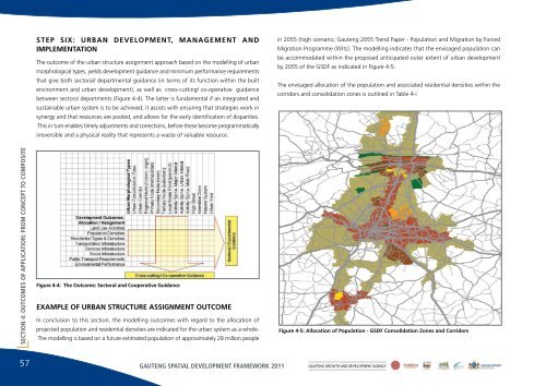
STEP SIX: URBAN DEVELOPMENT, MANAGEMENT ANDIMPLEMENTATIONThe outcome of <strong>the</strong> urban structure assignment approach based on <strong>the</strong> modelling of urbanmorphological types, yields <strong>development</strong> guidance and minimum performance requirementsthat give both sectoral/ departmental guidance (in terms of its function within <strong>the</strong> builtenvironment and urban <strong>development</strong>), as well as cross-cutting/ co-operative guidancebetween sectors/ departments (Figure 4-4). The latter is fundamental if an integrated andsustainable urban system is to be achieved; it assists with ensuring that strategies work insynergy and that resources are pooled, and allows for <strong>the</strong> early identification of disparities.This in turn enables timely adjustments and corrections, before <strong>the</strong>se become programmaticallyirreversible and a physical reality that represents a waste of valuable resource.in 2055 (high scenario; <strong>Gauteng</strong> 2055 Trend Paper - Population and Migration by ForcedMigration Programme (Wits). The modelling indicates that <strong>the</strong> envisaged population canbe accommodated within <strong>the</strong> proposed anticipated outer extent of urban <strong>development</strong>by 2055 of <strong>the</strong> GSDF as indicated in Figure 4-5.The envisaged allocation of <strong>the</strong> population and associated residential densities within <strong>the</strong>corridors and consolidation zones is outlined in Table 4-iSECTION 4: OUTCOMES OF APPLICATION: FROM CONCEPT TO COMPOSITEFigure 4-4: The Outcome: Sectoral and Cooperative GuidanceEXAMPLE OF URBAN STRUCTURE ASSIGNMENT OUTCOMEIn conclusion to this section, <strong>the</strong> modelling outcomes with regard to <strong>the</strong> allocation ofprojected population and residential densities are indicated for <strong>the</strong> urban system as a whole.The modelling is based on a future estimated population of approximately 28 million peopleFigure 4-5: Allocation of Population - GSDF Consolidation Zones and Corridors57 GAUTENG SPATIAL DEVELOPMENT FRAMEWORK 2011 GAUTENG GROWTH AND DEVELOPMENT AGENCY
GSDF: INITIAL ALLOCATION OF POPULATION GROWTH & DENSITY<strong>Gauteng</strong> Population 2007<strong>Gauteng</strong> Target Population 2055Total population growth expectedAverage population growth per annum<strong>Gauteng</strong> Population estimate 2010For calculation exercise10,454,55328,000,00017,545,447365,53011,551,14311,500,000Sources:1. 2007 Population Figures, GSDF GIS- Stats SA CommunitySurvey 2007 Statistical Release2. High Scenario, <strong>Gauteng</strong> 2055 Trend Paper- Population & Migrationby Forced Migration Programme (Wits)Provincial Area Breakdown Year 2010 Population Increase Total Year 2055Urban Structure Zone Land Area (ha) PopulationWithin Proposed Urban Footprint / ExtentConsolidation ZonesCorridors & Usaz Areas / DistrictsNature Areas (within urban footprint)Voids (within urban footprint)Outside of Proposed Urban Footprint / ExtentRemaining Provincial Areas / Non-urbanNature AreasNote: Estimates exclude Sasolburg.Table 4-i: GSDF - Initial Allocation of Population Growth and DensityGross Density:2010 (p/ha)PopulationIncreaseGross Density:Growth (p/ha)PopulationGross Density:2055 (p/ha)219,829 4,826,431 22.0 7,694,015 35.0 12,520,446 57.0346,394 6,298,232 18.2 7,967,062 23.0 14,265,294 41.23,141 0.0 0.07,812 0.0 0.0Urban Subtotal 577,176 11,124,664 19.6 15,661,077 27.7 26,785,741 47.31,238,147 375,336 0.3 913,862 0.7 1,289,198 1.010,197 0.0 0.0 0.0Non-urban Subtotal 1,248,344 375,336 0.3 913,862 0.7 1,289,198 1.0Total 1,825,520 11,500,000 16,574,939 28,074,939Calculated off GIS 1,825,520Gross DensityNett DensityPopulation & Density Estimate within ProposedLand Area (ha) Total Gross Density: Assuming 2/3 of Nett Density: UnitUrban Footprint Land Area by 2055Population 2055 (p/ha) Land Area 2055 (p/ha) Density 20552055DevelopableProposed Urban Footprint / Extent 566,223 26,785,741 47 377,482 71 22Note: Assuming 3.2 persons per household, and one dwelling perhousehold.SECTION 4: OUTCOMES OF APPLICATION: FROM CONCEPT TO COMPOSITEGAUTENG SPATIAL DEVELOPMENT FRAMEWORK 2011GAUTENG GROWTH AND DEVELOPMENT AGENCY58
- Page 1:
THE GAUTENG SPATIAL DEVELOPMENT FRA
- Page 4 and 5:
TABLE OF CONTENTSSECTION 1: INTRODU
- Page 6 and 7:
Table A.2-iv: Summary - Typical per
- Page 8 and 9:
FIGURESSECTION 1: INTRODUCTIONFigur
- Page 10 and 11:
Figure A.2.4: Modelling key compone
- Page 12 and 13:
FOREWORD
- Page 14 and 15:
SECTION1:Introduction
- Page 16 and 17:
development framework around which
- Page 18 and 19:
SECTION 1: INTRODUCTIONcadastral in
- Page 20 and 21: Not only does it seem necessary to
- Page 22 and 23: SECTION 2: THE GSDF AS A CONCEPTA S
- Page 24 and 25: disasters, shortages and changes in
- Page 26 and 27: are to promote sustainability, equi
- Page 28 and 29: It is legislated that metropolitan
- Page 30 and 31: Similarly, there must be a consiste
- Page 32 and 33: The corridors reflected in the figu
- Page 34 and 35: Similarly, in the United Kingdom, i
- Page 36 and 37: • urban compactness, also noted i
- Page 38 and 39: With Johannesburg as the city syste
- Page 40 and 41: Making sense of, and integrating, t
- Page 42 and 43: Based on this figure, it is suggest
- Page 44 and 45: On this basis, there is no reason w
- Page 46 and 47: SECTION 2: THE GSDF AS A CONCEPTPRI
- Page 48 and 49: SECTION 2: THE GSDF AS A CONCEPTPRI
- Page 50 and 51: SECTION3:The modelling elements of
- Page 52 and 53: value that goes with this can be de
- Page 54 and 55: THE MODELLING THAT UNDERPINS THE GS
- Page 56 and 57: MODEL 2: THE MORPHOLOGICAL MODELaro
- Page 58 and 59: with lower levels of accessibility.
- Page 60 and 61: MODEL 5: THE VIRTUAL MODEL ROOMSECT
- Page 62 and 63: URBAN MANAGEMENT AND SPATIAL DEVELO
- Page 64 and 65: making processes around these (for
- Page 66 and 67: The intricacies of the urban struct
- Page 68 and 69: SECTION 4: OUTCOMES OF APPLICATION:
- Page 72 and 73: THE COMPOSITE SPATIAL STRUCTUREThe
- Page 74 and 75: SECTION 4: OUTCOMES OF APPLICATION:
- Page 76 and 77: FRAMEWORK FOR THE IMPLEMENTATION OF
- Page 78 and 79: SECTION 5: FRAMEWORK FOR THE IMPLEM
- Page 80 and 81: TRANSPORTATIONThe principles of urb
- Page 82 and 83: URBAN STRUCTURING INITIATIVESSECTIO
- Page 84 and 85: SECTION 5: FRAMEWORK FOR THE IMPLEM
- Page 86 and 87: It is not enough, however, to simpl
- Page 88 and 89: APPENDIXA.1: The urban profile mode
- Page 90 and 91: ANNEXURE A: THE 5 GIS-BASED MODELSF
- Page 92 and 93: THE IDENTIFICATION OF MORPHOLOGICAL
- Page 94 and 95: ANNEXURE A: THE 5 GIS-BASED MODELSU
- Page 96 and 97: DEFINING THE MORPHOLOGICAL COMPONEN
- Page 98 and 99: • Activity Spines, with a hierarc
- Page 100 and 101: ANNEXURE A: THE 5 GIS-BASED MODELSN
- Page 102 and 103: comprises specialised trade, such a
- Page 104 and 105: • Development Intensity: Land are
- Page 106 and 107: THE REGIONAL NODEDevelopment Yield:
- Page 108 and 109: THE TYPICAL PERFORMANCE DIMENSION O
- Page 110 and 111: TYPICAL DEVELOPMENT PARAMETERS: URB
- Page 112 and 113: ANNEXURE A: THE 5 GIS-BASED MODELSF
- Page 114 and 115: ANNEXURE A: THE 5 GIS-BASED MODELSF
- Page 116 and 117: Figures A.2.13-15 show the same are
- Page 118 and 119: ANNEXURE A: THE 5 GIS-BASED MODELSF
- Page 120 and 121:
THE CONNECTIVITY MODELANNEXURE A: T
- Page 122 and 123:
CONNECTIVITY MODEL 2This iteration
- Page 124 and 125:
CONNECTIVITY MODEL 4The fourth iter
- Page 126 and 127:
CONNECTIVITY MODEL 6The final itera
- Page 128 and 129:
THE BID-RENT MODELThe Bid-Rent Mode
- Page 130 and 131:
TOPOGRAPHIC SUITABILITYThe Topograp
- Page 132 and 133:
THE SPATIAL POLICY SUPPORT INDEXThe
- Page 134 and 135:
SURFACE CONSTRAINTSThe Surface Cons
- Page 136 and 137:
APPENDIXA.5Model 5 - the virtualmod
- Page 138 and 139:
TSHWANE STATIONS123Existing conditi
- Page 140 and 141:
APPENDIXB.1: Restrictingurban spraw
- Page 142 and 143:
urban edge, many of the municipal S
- Page 144 and 145:
ANNEXURE B: POLICY POSITION PAPERSF
- Page 146 and 147:
APPENDIXB.2: A densification policy
- Page 148 and 149:
The model that is to guide both res
- Page 150 and 151:
APPENDIXB.3: Harmonisinghousingprov
- Page 152 and 153:
housing and mixed-uses can be reali
- Page 154 and 155:
ANNEXURE B: POLICY POSITION PAPERSF
- Page 156 and 157:
ANNEXURE B: POLICY POSITION PAPERSF
- Page 158 and 159:
THE PRINCIPLES GOVERNING THE TRANSP
- Page 160 and 161:
ANNEXURE B: POLICY POSITION PAPERSi
- Page 162 and 163:
Possible outer extentsof urban deve
- Page 164 and 165:
APPENDIXB.5: Thecase principles ofs
- Page 166 and 167:
sustainable and efficient. A long-t
- Page 168 and 169:
ANNEXURE B: POLICY POSITION PAPERSB
- Page 170 and 171:
APPENDIXC.1: Thefreight and logisti
- Page 172 and 173:
overall platform on which more focu
- Page 174 and 175:
A further south-eastern regional hu
- Page 176 and 177:
ANNEXURE C: POLICY PERSPECTIVESFigu
- Page 178 and 179:
APPENDIXC.2: A perspective guidingt
- Page 180 and 181:
anges of hills or mountains, whethe
- Page 182 and 183:
APPENDIXC.3: Preservationof landhav
- Page 184 and 185:
ANNEXURE C: POLICY PERSPECTIVESFigu
- Page 186 and 187:
URBAN CONSOLIDATION ZONESThe physic
- Page 188 and 189:
APPENDIXC.5: Indicativepatterns ofe
- Page 190 and 191:
ANNEXURE C: POLICY PERSPECTIVESFigu
- Page 192 and 193:
ANNEXURE C: POLICY PERSPECTIVESFigu
- Page 194 and 195:
APPENDIXC.6: Integrationof the rura
- Page 196 and 197:
opportunity that goes with being ab
- Page 198 and 199:
ANNEXURED: The package of plans
- Page 200 and 201:
In order to achieve spatial integri
- Page 202 and 203:
LEVEL ESSENTIAL FOCUS AND SCOPE SCA
- Page 204 and 205:
LEVEL ESSENTIAL FOCUS AND SCOPE SCA
- Page 206 and 207:
ANNEXUREE: Glossary of terms
- Page 208 and 209:
Brownfield Land and SitesPreviously
- Page 210 and 211:
ANNEXURE E: GLOSSARY OF TERMSTown -
- Page 212 and 213:
Development ManagementThe process w
- Page 214 and 215:
Geographic Spread Programme (DTI)Th
- Page 216 and 217:
ANNEXURE E: GLOSSARY OF TERMSIntegr
- Page 218 and 219:
ANNEXURE E: GLOSSARY OF TERMSSpatia
- Page 220 and 221:
ANNEXURE E: GLOSSARY OF TERMSUrban
- Page 222:
ANNEXURE E: GLOSSARY OF TERMS• Ur