- Page 1:
THE GAUTENG SPATIAL DEVELOPMENT FRA
- Page 4 and 5:
TABLE OF CONTENTSSECTION 1: INTRODU
- Page 6 and 7:
Table A.2-iv: Summary - Typical per
- Page 8 and 9:
FIGURESSECTION 1: INTRODUCTIONFigur
- Page 10 and 11:
Figure A.2.4: Modelling key compone
- Page 12 and 13:
FOREWORD
- Page 14 and 15:
SECTION1:Introduction
- Page 16 and 17:
development framework around which
- Page 18 and 19:
SECTION 1: INTRODUCTIONcadastral in
- Page 20 and 21:
Not only does it seem necessary to
- Page 22 and 23:
SECTION 2: THE GSDF AS A CONCEPTA S
- Page 24 and 25:
disasters, shortages and changes in
- Page 26 and 27:
are to promote sustainability, equi
- Page 28 and 29:
It is legislated that metropolitan
- Page 30 and 31:
Similarly, there must be a consiste
- Page 32 and 33:
The corridors reflected in the figu
- Page 34 and 35:
Similarly, in the United Kingdom, i
- Page 36 and 37:
• urban compactness, also noted i
- Page 38 and 39:
With Johannesburg as the city syste
- Page 40 and 41:
Making sense of, and integrating, t
- Page 42 and 43:
Based on this figure, it is suggest
- Page 44 and 45:
On this basis, there is no reason w
- Page 46 and 47: SECTION 2: THE GSDF AS A CONCEPTPRI
- Page 48 and 49: SECTION 2: THE GSDF AS A CONCEPTPRI
- Page 50 and 51: SECTION3:The modelling elements of
- Page 52 and 53: value that goes with this can be de
- Page 54 and 55: THE MODELLING THAT UNDERPINS THE GS
- Page 56 and 57: MODEL 2: THE MORPHOLOGICAL MODELaro
- Page 58 and 59: with lower levels of accessibility.
- Page 60 and 61: MODEL 5: THE VIRTUAL MODEL ROOMSECT
- Page 62 and 63: URBAN MANAGEMENT AND SPATIAL DEVELO
- Page 64 and 65: making processes around these (for
- Page 66 and 67: The intricacies of the urban struct
- Page 68 and 69: SECTION 4: OUTCOMES OF APPLICATION:
- Page 70 and 71: STEP SIX: URBAN DEVELOPMENT, MANAGE
- Page 72 and 73: THE COMPOSITE SPATIAL STRUCTUREThe
- Page 74 and 75: SECTION 4: OUTCOMES OF APPLICATION:
- Page 76 and 77: FRAMEWORK FOR THE IMPLEMENTATION OF
- Page 78 and 79: SECTION 5: FRAMEWORK FOR THE IMPLEM
- Page 80 and 81: TRANSPORTATIONThe principles of urb
- Page 82 and 83: URBAN STRUCTURING INITIATIVESSECTIO
- Page 84 and 85: SECTION 5: FRAMEWORK FOR THE IMPLEM
- Page 86 and 87: It is not enough, however, to simpl
- Page 88 and 89: APPENDIXA.1: The urban profile mode
- Page 90 and 91: ANNEXURE A: THE 5 GIS-BASED MODELSF
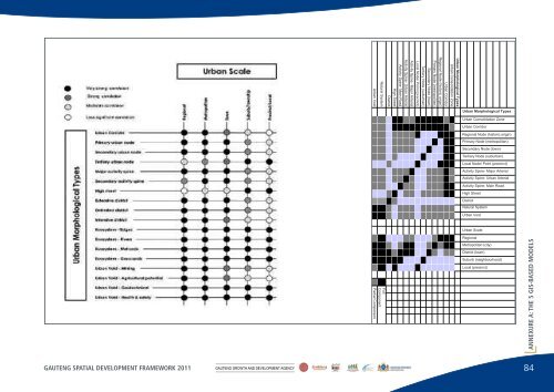
- Page 92 and 93: THE IDENTIFICATION OF MORPHOLOGICAL
- Page 94 and 95: ANNEXURE A: THE 5 GIS-BASED MODELSU
- Page 98 and 99: • Activity Spines, with a hierarc
- Page 100 and 101: ANNEXURE A: THE 5 GIS-BASED MODELSN
- Page 102 and 103: comprises specialised trade, such a
- Page 104 and 105: • Development Intensity: Land are
- Page 106 and 107: THE REGIONAL NODEDevelopment Yield:
- Page 108 and 109: THE TYPICAL PERFORMANCE DIMENSION O
- Page 110 and 111: TYPICAL DEVELOPMENT PARAMETERS: URB
- Page 112 and 113: ANNEXURE A: THE 5 GIS-BASED MODELSF
- Page 114 and 115: ANNEXURE A: THE 5 GIS-BASED MODELSF
- Page 116 and 117: Figures A.2.13-15 show the same are
- Page 118 and 119: ANNEXURE A: THE 5 GIS-BASED MODELSF
- Page 120 and 121: THE CONNECTIVITY MODELANNEXURE A: T
- Page 122 and 123: CONNECTIVITY MODEL 2This iteration
- Page 124 and 125: CONNECTIVITY MODEL 4The fourth iter
- Page 126 and 127: CONNECTIVITY MODEL 6The final itera
- Page 128 and 129: THE BID-RENT MODELThe Bid-Rent Mode
- Page 130 and 131: TOPOGRAPHIC SUITABILITYThe Topograp
- Page 132 and 133: THE SPATIAL POLICY SUPPORT INDEXThe
- Page 134 and 135: SURFACE CONSTRAINTSThe Surface Cons
- Page 136 and 137: APPENDIXA.5Model 5 - the virtualmod
- Page 138 and 139: TSHWANE STATIONS123Existing conditi
- Page 140 and 141: APPENDIXB.1: Restrictingurban spraw
- Page 142 and 143: urban edge, many of the municipal S
- Page 144 and 145: ANNEXURE B: POLICY POSITION PAPERSF
- Page 146 and 147:
APPENDIXB.2: A densification policy
- Page 148 and 149:
The model that is to guide both res
- Page 150 and 151:
APPENDIXB.3: Harmonisinghousingprov
- Page 152 and 153:
housing and mixed-uses can be reali
- Page 154 and 155:
ANNEXURE B: POLICY POSITION PAPERSF
- Page 156 and 157:
ANNEXURE B: POLICY POSITION PAPERSF
- Page 158 and 159:
THE PRINCIPLES GOVERNING THE TRANSP
- Page 160 and 161:
ANNEXURE B: POLICY POSITION PAPERSi
- Page 162 and 163:
Possible outer extentsof urban deve
- Page 164 and 165:
APPENDIXB.5: Thecase principles ofs
- Page 166 and 167:
sustainable and efficient. A long-t
- Page 168 and 169:
ANNEXURE B: POLICY POSITION PAPERSB
- Page 170 and 171:
APPENDIXC.1: Thefreight and logisti
- Page 172 and 173:
overall platform on which more focu
- Page 174 and 175:
A further south-eastern regional hu
- Page 176 and 177:
ANNEXURE C: POLICY PERSPECTIVESFigu
- Page 178 and 179:
APPENDIXC.2: A perspective guidingt
- Page 180 and 181:
anges of hills or mountains, whethe
- Page 182 and 183:
APPENDIXC.3: Preservationof landhav
- Page 184 and 185:
ANNEXURE C: POLICY PERSPECTIVESFigu
- Page 186 and 187:
URBAN CONSOLIDATION ZONESThe physic
- Page 188 and 189:
APPENDIXC.5: Indicativepatterns ofe
- Page 190 and 191:
ANNEXURE C: POLICY PERSPECTIVESFigu
- Page 192 and 193:
ANNEXURE C: POLICY PERSPECTIVESFigu
- Page 194 and 195:
APPENDIXC.6: Integrationof the rura
- Page 196 and 197:
opportunity that goes with being ab
- Page 198 and 199:
ANNEXURED: The package of plans
- Page 200 and 201:
In order to achieve spatial integri
- Page 202 and 203:
LEVEL ESSENTIAL FOCUS AND SCOPE SCA
- Page 204 and 205:
LEVEL ESSENTIAL FOCUS AND SCOPE SCA
- Page 206 and 207:
ANNEXUREE: Glossary of terms
- Page 208 and 209:
Brownfield Land and SitesPreviously
- Page 210 and 211:
ANNEXURE E: GLOSSARY OF TERMSTown -
- Page 212 and 213:
Development ManagementThe process w
- Page 214 and 215:
Geographic Spread Programme (DTI)Th
- Page 216 and 217:
ANNEXURE E: GLOSSARY OF TERMSIntegr
- Page 218 and 219:
ANNEXURE E: GLOSSARY OF TERMSSpatia
- Page 220 and 221:
ANNEXURE E: GLOSSARY OF TERMSUrban
- Page 222:
ANNEXURE E: GLOSSARY OF TERMS• Ur