the gauteng spatial development framework - Gauteng Online
the gauteng spatial development framework - Gauteng Online
the gauteng spatial development framework - Gauteng Online

Create successful ePaper yourself
Turn your PDF publications into a flip-book with our unique Google optimized e-Paper software.
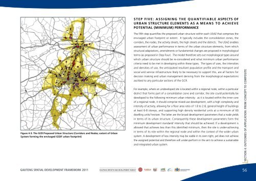
STEP FIVE: ASSIGNING THE QUANTIFIABLE ASPECTS OFURBAN STRUCTURE ELEMENTS AS A MEANS TO ACHIEVEPOTENTIAL (MINIMUM) PERFORMANCEFigure 4-3: The GCR Proposed Urban Structure (Corridors and Nodes; extent of UrbanSystem forming <strong>the</strong> envisaged GSDF urban footprint)The fifth step quantifies <strong>the</strong> proposed urban structure within each USAZ that comprises <strong>the</strong>envisaged urban footprint or extent. It typically includes <strong>the</strong> consolidation zones, <strong>the</strong>corridors, <strong>the</strong> nodes, <strong>the</strong> activity streets, <strong>the</strong> high streets and <strong>the</strong> districts. The USAZ enablesassessment of urban performance in terms of <strong>the</strong> urban structure elements, from whichstructural adaptations, amendments or fundamental changes are proposed in morphologicalterms (as proposed in Step Four). The model <strong>the</strong>refore sets out morphological types aroundwhich urban structure should be re-considered and what minimum urban performancecriteria need to be met in developing within <strong>the</strong>se types. The types of uses, <strong>the</strong> intensitiesand densities of use, <strong>the</strong> anticipated resultant population profile and <strong>the</strong> transport andsocial and service infrastructure likely to be necessary to support this, are all factors fordecision making and urban management deriving from <strong>the</strong> morphological expectationsascribed to any particular sections of <strong>the</strong> GCR.For example, where an undeveloped site is located within a regional node, within a particulardistrict that forms part of a consolidation zone and corridor, <strong>the</strong> site could potentially bedeveloped to <strong>the</strong> following minimum urban intensity: as it is located within <strong>the</strong> inner coreof a regional node, it should comprise mixed-use <strong>development</strong>, with a high complexity andintensity of activity, allowing for a floor area ratio of 1.8 to 2.8, general height of buildingsat least 6-8 storeys, and supporting high density residential units at a minimum of 60dwelling units/ hectare. The latter are <strong>the</strong> broad <strong>development</strong> parameters that a node yieldsin terms of its urban structure. Consequently <strong>the</strong>se <strong>development</strong> parameters form <strong>the</strong>minimum <strong>development</strong> standard/ intensity that should be achieved. If a <strong>development</strong> isallowed that achieves less than this identified minimum, <strong>the</strong>n <strong>the</strong> site is under-achievingin terms of its role within <strong>the</strong> regional node and within <strong>the</strong> context of <strong>the</strong> wider urbansystem. A <strong>development</strong> of less intensity may be viable in its own right, yet does not achieve<strong>the</strong> assigned potential and <strong>the</strong>refore will under-perform in <strong>the</strong> aim to achieve a sustainableand integrated urban system.SECTION 4: OUTCOMES OF APPLICATION: FROM CONCEPT TO COMPOSITEGAUTENG SPATIAL DEVELOPMENT FRAMEWORK 2011GAUTENG GROWTH AND DEVELOPMENT AGENCY56