the gauteng spatial development framework - Gauteng Online
the gauteng spatial development framework - Gauteng Online
the gauteng spatial development framework - Gauteng Online

You also want an ePaper? Increase the reach of your titles
YUMPU automatically turns print PDFs into web optimized ePapers that Google loves.
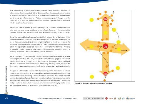
With Johannesburg as <strong>the</strong> city system at <strong>the</strong> core of <strong>Gauteng</strong> accounting for some 4.5million people, <strong>the</strong>re is increasingly little to distinguish it from <strong>the</strong> expanded nor<strong>the</strong>rn systemof Tshwane (with Pretoria at <strong>the</strong> core) or its sou<strong>the</strong>rn system of Emfuleni (Vanderbijlparkand Vereeniging). Johannesburg and Pretoria are more appropriately thought of as <strong>the</strong>central foci of an expanded urban system of some 11 million people and thus hold somevaluable lessons and observations.It is possible, from an apparent apar<strong>the</strong>id <strong>spatial</strong> legacy of 'non-sense', to derive clues thatpoint towards a sustainable proposition of 'sense' (what, in <strong>the</strong> context of <strong>the</strong> abnormalitiesspawned by apar<strong>the</strong>id, represents that most extraordinary thing of all-normality).One of <strong>the</strong> most debilitating legacies of apar<strong>the</strong>id still felt on a day-to-day basis in SouthAfrican settlements is that of <strong>the</strong> distorted <strong>spatial</strong> pattern of our cities. Indeed, possiblyone of <strong>the</strong> most serious abiding concerns for planning for, to all intents and purposes, <strong>the</strong>foreseeable future (certainly for <strong>the</strong> 2055 horizon of <strong>the</strong> current provincial planning initiative)is that of integrating <strong>the</strong> dislocated, marginalised pattern of dysfunction into a structureof normality. In order to assess whe<strong>the</strong>r meaningful re-integration is indeed possible, it isnecessary to search out <strong>the</strong> clues in 'Making sense of Nonsense'SECTION 2: THE GSDF AS A CONCEPTBefore <strong>the</strong> advent of 'grand apar<strong>the</strong>id', one saw <strong>the</strong> emergence of an extended urban areacomprising Johannesburg at <strong>the</strong> core, Pretoria to <strong>the</strong> north and Vereeniging (later consolidatedwith Vanderbijlpark) to <strong>the</strong> south. A cruciform system of <strong>development</strong> axes consolidatedinitially in an east-west format coincidental with mining and later, as infill, between <strong>the</strong>three major urban nodes represented by Pretoria, Johannesburg and Vanderbijlpark.Two types of satellite nodes are discernible: those strongly within <strong>the</strong> influence of a majorcentre such as Johannesburg or Pretoria and having relatively incomplete or less complexurban profiles (Florida, Randburg, Sandton, Germiston, Alberton). Those fur<strong>the</strong>r removedfrom <strong>the</strong> dominating influence of a primary core allowing for a more complex urban profile(Kempton Park, Roodepoort, Halfway House [now Midrand] and Boksburg). A seeminglyshotgun-scatter of <strong>the</strong>se urban nodes was, however, driven effectively by market needsand conventional patterns of settlement in a consolidating city context.Figure 2-11: <strong>Gauteng</strong>'s urban system advent of apar<strong>the</strong>id25 GAUTENG SPATIAL DEVELOPMENT FRAMEWORK 2011 GAUTENG GROWTH AND DEVELOPMENT AGENCY