the gauteng spatial development framework - Gauteng Online
the gauteng spatial development framework - Gauteng Online
the gauteng spatial development framework - Gauteng Online

Create successful ePaper yourself
Turn your PDF publications into a flip-book with our unique Google optimized e-Paper software.
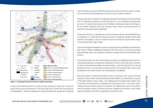
and <strong>the</strong> significant amount of RDP housing that has been put into this nascent corridor,more should be promoted regionally to make it live up to a greater potential.The east-west urban corridor from Krugersdorp through Johannesburg (via <strong>the</strong> West Rand)and on to Boksburg and Benoni (via <strong>the</strong> East Rand) is in turn extremely strong eastwardsby virtue of its regional and national links to Witbank, Middelburg, Nelspruit and Maputo.On <strong>the</strong> western extremity of this axis, however, <strong>the</strong>re is little to significantly inform itsextension westwards beyond Krugersdorp.To <strong>the</strong> extent that this is so (and bearing in mind <strong>the</strong> relatively weak axis through Potchefstroomto Kimberley), it is noted that <strong>the</strong> fairly poor economic integration between North WestProvince and <strong>Gauteng</strong> is cause for regional concern and leaves <strong>the</strong> south-western sectorof <strong>the</strong> <strong>Gauteng</strong> urban region fragile.The east-west regional <strong>development</strong> axis from Angola, Botswana and Maputo via Rustenburg,Brits, Pretoria, Witbank, Middelburg and Nelspruit (<strong>the</strong> N4 Corridor) is, by contrast, relativelyrobust although, again, <strong>the</strong> integration to <strong>the</strong> east is stronger than that with <strong>the</strong> North WestProvince.The N3 <strong>development</strong> axis from Johannesburg to Durban via Heidelberg and Harrismith iseconomically significant and represents a bifurcation of <strong>the</strong> N1 north-south intra-continentalcorridor at a point between Midrand and Johannesburg. Given <strong>the</strong> strength of this national<strong>development</strong> axis, one senses that more performance in <strong>the</strong> <strong>Gauteng</strong> urban system couldbe expected of <strong>the</strong> urban corridor from Johannesburg to Heidelberg.Figure 1-1: <strong>Gauteng</strong> Province in context of adjacent provincesIn spite of <strong>the</strong> relatively robust N1 Corridor through <strong>Gauteng</strong> to Cape Town, one wouldexpect more economic performance in <strong>the</strong> fairly weak urban corridor from Johannesburgto Vanderbijlpark. Given <strong>the</strong> importance of Soweto, Eldorado Park, Orange Farm, SebokengNoting <strong>the</strong> pattern of regional <strong>development</strong> axes converging on and passing through<strong>Gauteng</strong>, and how <strong>the</strong>se fundamentally provide <strong>the</strong> skeleton (or morphological structure)of <strong>the</strong> wider <strong>Gauteng</strong> urban system, <strong>the</strong> inadequacies in this wider system appear to bein <strong>the</strong> failure of well-balanced, sustainable local economies to form in <strong>the</strong> south, southwesternand south-eastern sectors of <strong>the</strong> system. To a slightly lesser extent, <strong>the</strong> nor<strong>the</strong>rnand north-western sectors of Tshwane also show inadequacies and <strong>the</strong>se in areas wheresignificant peripheral (and often marginalised) communities exist.SECTION 1: INTRODUCTIONGAUTENG SPATIAL DEVELOPMENT FRAMEWORK 2011GAUTENG GROWTH AND DEVELOPMENT AGENCY06