the gauteng spatial development framework - Gauteng Online
the gauteng spatial development framework - Gauteng Online
the gauteng spatial development framework - Gauteng Online

Create successful ePaper yourself
Turn your PDF publications into a flip-book with our unique Google optimized e-Paper software.
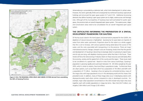
Johannesburg is surrounded by a dolomitic belt, which limits <strong>development</strong> in certain areas.However, this land is generally fertile and consequently has reinforced <strong>Gauteng</strong>'s agriculturalholdings and structured <strong>the</strong> open space system (2-7 and 2-10). Additional structuringelements that define <strong>Gauteng</strong>'s open space system are its ridges, watercourses and heritagesites. Although all <strong>the</strong> municipalities of <strong>Gauteng</strong> have land earmarked for public openspace, <strong>the</strong> province lacks an overall integrated open space system. The watercourses, ridgesand conservation areas need to be consolidated into an overall integrated open spacesystem.THE CRITICALITIES INFORMING THE PREPARATION OF A SPATIALDEVELOPMENT FRAMEWORK FOR GAUTENGFigure 2-10.b: THE REGIONAL OPEN SPACE AND GREEN SYSTEM derived from assembling<strong>the</strong> SDFs of <strong>Gauteng</strong> ProvinceOf <strong>the</strong> key issues raised in <strong>the</strong> trend papers and presentations prepared for <strong>the</strong> G2055, <strong>the</strong>depletion of natural resources is highlighted. <strong>Gauteng</strong> has for years been an importer ofwater from o<strong>the</strong>r water catchments. Projections done for <strong>the</strong> nation as a whole suggestthat this is set to increase, with serious questions being asked about <strong>the</strong> source of thiswater, and <strong>the</strong> costs associated with transporting it to <strong>the</strong> province. There are majorinternational economic changes; transport costs are increasing; trends show that <strong>the</strong> growthand <strong>development</strong> of <strong>Gauteng</strong> is becoming increasingly reliant on growing its export base;and oil costs are rising, with depletion looming sooner ra<strong>the</strong>r than later in <strong>the</strong> future. Thesetrends will force <strong>the</strong> restructuring of industry reliant on <strong>the</strong>se resources and ultimately affect<strong>the</strong> economy, society and <strong>the</strong> <strong>spatial</strong> form of <strong>the</strong> country and <strong>the</strong> region. These issues needto be considered on a <strong>spatial</strong> level. Based on notes from various workshops, <strong>Gauteng</strong>'spopulation is growing rapidly and could reach between 18 - 28 million people by <strong>the</strong> year2055, which is similar to Jakarta, Seoul and Tokyo's populations today. Fur<strong>the</strong>rmore <strong>the</strong>reare urban systems, such as Sao Paolo which has a population of 18 million and Delhi witha population of 17 million. <strong>Gauteng</strong> is thus not going into uncharted territory; many of<strong>the</strong> mega-cities with large populations occur in <strong>the</strong> developing world and this means thatprecedents exist. In addition, many of <strong>the</strong>se mega-cities occur in developing nations withdisproportionately sized urban centres compared to cities in developed countries. Forexample, major urban population concentrations in <strong>the</strong> USA include many major cities closetoge<strong>the</strong>r, each with smaller populations in mega-city terms - New York (8.27 million), LosAngeles (3.84 million) and Chicago (2.83 million).SECTION 2: THE GSDF AS A CONCEPTGAUTENG SPATIAL DEVELOPMENT FRAMEWORK 2011GAUTENG GROWTH AND DEVELOPMENT AGENCY20