

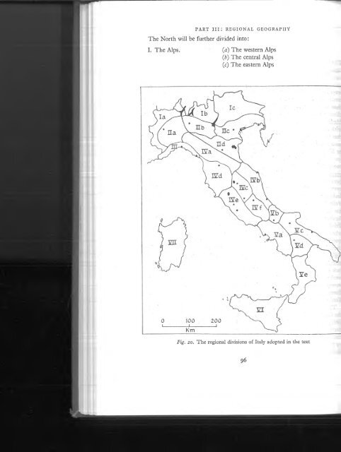
Walker - 1967 - A geography of Italy
Walker - 1967 - A geography of Italy
Walker - 1967 - A geography of Italy

Create successful ePaper yourself
Turn your PDF publications into a flip-book with our unique Google optimized e-Paper software.
THE ALPS<br />
the frontier in the Lugano area. With the exception o f the Splügen, the summits<br />
<strong>of</strong> all the main passes lie within Swiss territory; on the other hand two very small<br />
sectors o f <strong>Italy</strong> are drained northwards, one (the Lei valley) to the Hinter Rhein,<br />
the other (the Spöl valley) to the Inn.<br />
From the Northern Plain to the crests o f the Bernina and Lepontine Alps, the<br />
mountain zone varies in width from 6o to lOO km. It is penetrated by a number o f<br />
deep low-level valleys, both transverse and longitudinal, which favoured the<br />
spread <strong>of</strong> the Italian type o f settlement as far as the watershed. The occurrence <strong>of</strong><br />
longitudinal valleys, notably the Valtellina, Val Brega, Val Vigezzo and the<br />
middle Ticino (between Locarno and Bellinzona), is in marked contrast to the<br />
western Alps. The numerous transverse valleys, o f which the Val d’Ossola, Val<br />
Levantina, Val Mesocco, the Liro-M era valley and the Val Camonica are the<br />
most important, <strong>of</strong>fer a wide choice o f trans-Alpine passes. All the major valleys,<br />
most o f them following fault zones, have been overdeepened by glaciers which<br />
were thick enough in places to have scored the valley sides to a height o f 1500m.<br />
Lakes Maggiore (Verbano), Como (Lario) and Iseo have been gouged out to<br />
reach depths o f 372, 410 and 251m respectively; this means that at their deepest<br />
points their beds are well below sea level. The higher valleys, many o f which are<br />
notched with a post-glacial V , are impeded with moraines and occasionally graded<br />
into valley steps (Val Mesocco). The lower valleys on the other hand, although<br />
steep-sided, are floored by a ribbon o f alluvium with here and there the shallow<br />
remnants o f once more extensive lakes. Well-drained detritus cones provide useful<br />
cultivable land and favourite sites for settlement.<br />
Structurally one o f the main contrasts between the central and the western<br />
Alps is the presence in the latter o f a Pre-Alpine zone. As in all the Pre-Alps this<br />
sector is predominantly calcareous, as opposed to the crystalline Alpine core.<br />
The jimction between the two zones lies somewhat southwards o f the major fault<br />
zone, known as the Tonale or Insubrica line, which runs from Domodossola<br />
±rough Locarno, Sondrio, and the Tonale col and so along the Val di Sole to<br />
Cles. Throughout much o f its length this line <strong>of</strong> weakness has been exploited by<br />
the Adda, Oglio and Noce to provide an easy longitudinal routeway (fig. 22),<br />
Between Lake Maggiore and the Lecco arm o f Como the Pre-Alpine zone is<br />
much dissected by steep glaciated valleys, some o f them occupied by deep ribbon<br />
lakes, and the dominance o f the Jurassic limestones is broken by the exposure<br />
<strong>of</strong> Permian porphyries south o f Lugano. From Como to the Oglio valley (Val<br />
Camonica) the Pre-Alps constitute a massive block through which there is no<br />
satisfactory pass to the Valtellina. Here within a short distance o f the plain the<br />
rounded, rather s<strong>of</strong>t Cretaceous and Jurassic limestones are replaced by Triassic<br />
rocks, mainly tough limestones and dolomites with some marls. The dolomites<br />
produce the highest and most rugged relief in the Bergamasque Pre-Alps, for<br />
example le Grigne, Pizzo Arera and Pizzo di Presolana, all o f them over 2400m.<br />
The Brembo and the Serio, with their tributaries, cut through the Triassic<br />
limestones in deep steep-sided valleys, but where the marls occm the relief is less<br />
103


