

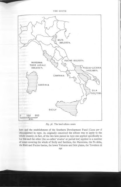
Walker - 1967 - A geography of Italy
Walker - 1967 - A geography of Italy
Walker - 1967 - A geography of Italy

Create successful ePaper yourself
Turn your PDF publications into a flip-book with our unique Google optimized e-Paper software.
PART I I I : REGION A L GEOGRAPHY<br />
tlfSBi.‘? f l s t :» -i ^ r r<br />
railways and the decline in wool prices in the face o f overseas competition, the<br />
masserie began to take an increasing interest in wheat production, an activity<br />
which dovetailed well with sheep rearing. At the same time an influx o f labourers<br />
transformed the villages into towns without greatly changing their function.<br />
Although at harvest time the Tavoliere attracted temporary labour from all over<br />
the continental South, the permanent giomalieri suffered from serious underemployment<br />
and their livelihood was increasingly menaced by mechanization.<br />
Between the wars consorzi di bonifica made some modest progress in improving<br />
the area which now assumed an important rôle in the ‘Battle for Grain’. The<br />
conversion o f Lake Salpi into salt pans was completed. Lake Salso was reclaimed<br />
by colmate, and a number o f settlements, based on poderi, were fotmded under<br />
the aegis o f ex-servicemen’s organizations (e.g. Mezzanone). The environs o f the<br />
towns were increasingly taken over by small cultivators, and tree crops, notably<br />
olives round Cerignola and vines near S. Severe, continued to modify the traditional<br />
land-use, but in 1946 the Tavoliere was still essentially a vast cultural<br />
steppe, studded with masserie and overcrowded townships. Since 1950, under the<br />
land reform, the hydrological problems have been tackled with vigour. Malaria<br />
has been practically ehminated; over 57,000 hectares in Foggia province have<br />
been appropriated and settled; and some 125,000 hectares are being provided<br />
with irrigation along the lower Fortore, on the right bank o f the middle Ofanto,<br />
and most extensively between the Candelaro and the Foggia-S. Severn road.<br />
Although about 38% o f Foggia province is still in properties o f over 50 hectares,<br />
a very high figure for <strong>Italy</strong>, the trend towards a more intensive and varied landuse<br />
and a wider distribution o f ownership is firmly established. Even so the<br />
problem o f rural overpopulation is far from solved; towns like Foggia (118,000),<br />
which has managed to attract food processing, agricultural machinery and textile<br />
industries on a modest scale, must be further industrialized and it is unlikely that<br />
emigration can be avoided for a long time yet.<br />
The M m ge and the Salentine peninsula constitute a structural unit but they<br />
are best considered separately. Lying between the Ofanto and a line joining<br />
Brindisi and Taranto, and rising to 686m in Torre Disperata, the Murge tableland<br />
is composed o f Cretaceous limestone gently folded on a N W -SE axis. On<br />
its southern flank, where the limestones are down-faulted, the plateau falls<br />
abruptly and irregularly to the Bradano trench and the amphitheatre <strong>of</strong> Taranto.<br />
Northwards it descends to the sea across three escarpments; the first and highest<br />
o f these, which corresponds roughly with the 300m contour, marks the edge <strong>of</strong><br />
the high plateau top - the Alte Murge. The other two much lower escarpments,<br />
running roughly parallel to the coast, convert the lower Murge into three shallow<br />
steps. The relative importance o f faulting and o f marine or sub-aerial peneplanation<br />
in the formation o f these steps is variously assessed. Although the plateau is<br />
lapped by Pliocene-Quaternary sediments on its southern and western flanks,<br />
and similar deposits have survived on its upper surface (notably along the coast<br />
between Barletta and Bisceghe, near Bari, south o f Monopoli and at Gioia) it is<br />
204


