

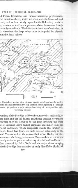
Walker - 1967 - A geography of Italy
Walker - 1967 - A geography of Italy
Walker - 1967 - A geography of Italy

You also want an ePaper? Increase the reach of your titles
YUMPU automatically turns print PDFs into web optimized ePapers that Google loves.
THE N ORTH ERN LOW LANDS<br />
Apennines feeders have certainly helped to determine the course o f the main<br />
artery. Above Piacenza the heavily charged Alpine tributaries pin the Po against<br />
the Apennine margin; downstream the Alpine feeders, despite their greater discharge,<br />
caimot compete with the enormous load o f the Apennine rivers. This<br />
contrast owes much to the absence o f lakes in the courses o f the Apennine rivers<br />
and the extremely erodible nature o f their catchment basins.<br />
A notable feature o f the Po’s Alpine feeders is the tendency they exhibit to<br />
turn eastwards in their lower coxurses. A possible explanation is that they were<br />
diverted by the very heavy load o f silt brought down by the Po itself at a time<br />
when its course was unconfined by levees; in much the same way the Adige is<br />
stiU obhged to find an independent outlet to the sea to the north o f the modern<br />
delta zone. It is perhaps significant that the easterly trend o f the tributaries becomes<br />
more marked downstream from a point where the heavily charged Apennine<br />
rivers begin to make their contribution to the Po.<br />
It will already be apparent that the seeming uniformity <strong>of</strong> the plain masks a<br />
great diversity o f relief, structure and hydrology. This diversity may not be<br />
obvious to the casual observer but its influence on the pattern o f cultivation and<br />
settlement is extremely important. In an attempt to simplify what is in fact very<br />
complex, the following physiographical zones may be recognized (fig. 27):<br />
I THE H ILL ZONE OF THE A LPIN E M ARGIN. This varies greatly in width, relief<br />
and composition. T o the south o f lakes Maggiore, Lugano, Como, Iseo and<br />
Garda, and where the Dora Riparia, Dora Baltea, Adige and Taghamento reach<br />
the plain, this zone is mainly developed on morainic arcs. As far as it has been<br />
possible to distinguish the contributions o f successive glacial phases, the Gunz<br />
deposits are exposed only where the major rivers have incised themselves deeply.<br />
The Mindel moraines, however, are extensively revealed and enclose within<br />
their arcs the fresher debris o f the last two glacial phases. T he characteristic<br />
terrain is usually one o f low irregular hills but occasionally more continuous arcs<br />
and ridges are recognizable; the most obvious example is the Serra dTvrea. In<br />
general the moraines are excessively permeable but in places, usually on the<br />
older surfaces, a chemical alteration associated with leaching has produced a<br />
clayey impermeable pan known as ferretto. The soils on the moraines are always<br />
acid but this tendency is particularly marked on the ferretto where, under natural<br />
conditions, the associated vegetation is a sterile heath (brughiere). In depressions<br />
among the morainic debris, where the water table reaches the surface or where<br />
glacial clays discourage seepage, peat bogs and lakes were a common feature o f<br />
the post-glacial landscape; most o f the peat bogs (torbiere) have been drained but<br />
a sprinkling <strong>of</strong> lakes survives within the Dora Baltea moraine (Viverone) and between<br />
the Ticino and the Adda (Varese, Comabbio).<br />
Elsewhere the hill country is developed on ‘sohd’ structures. In Lombardy and<br />
Piedmont these usually take the form <strong>of</strong> isolated spms or down-faulted fragments<br />
<strong>of</strong> the Alpine or Pre-Alpine margin (Saluzzo spur, Rocca di Cavour); in Veneto<br />
121<br />
N<br />
i


