- Page 2 and 3:
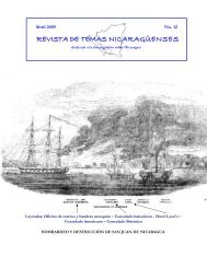
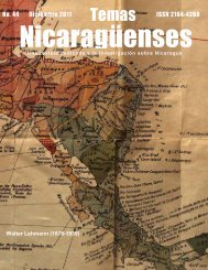
No. 56 - Diciembre 2012 ISSN 2164-4
- Page 4 and 5:
Editor: José Mejía Lacayo jmejial
- Page 6 and 7:
El 24 de Marzo de 1990, El Nuevo Di
- Page 8 and 9:
En nombre del común ideal que nos
- Page 10 and 11:
Carta dirigida a Don José Santos R
- Page 12 and 13:
Firma: Salvador Mendieta Carta diri
- Page 14 and 15:
de sus nobles aspiraciones y de su
- Page 16 and 17:
honor de Nicaragua, de Centro Amér
- Page 18 and 19:
EN 1899 NACIÓ EL PARTIDO UNIONISTA
- Page 20 and 21:
“Y esa es a mi juicio la razón e
- Page 22 and 23:
Sin embargo, el apóstol del unioni
- Page 24 and 25:
Introducción a La enfermedad de Ce
- Page 26 and 27:
da, la Mosquitia hondureña, la Ter
- Page 28 and 29:
afectó seriamente en su carácter
- Page 30 and 31:
que teosófico hace poco atractivo
- Page 32 and 33:
DEL ESCRITORIO DEL EDITOR Nicaragua
- Page 34 and 35:
El poderoso empuje de los vientos o
- Page 36 and 37:
CITERES y VENUS CITEREA En “Estiv
- Page 38 and 39:
El poeta de Nicaragua y el gran fra
- Page 40 and 41:
ción que sorprenderá a muchos fil
- Page 42 and 43:
nes. En fin, todo ese gran trabajo
- Page 44 and 45:
os; sin embargo, como la subasta p
- Page 46 and 47:
Honor de Sujeto y Vergüenza de Obj
- Page 48 and 49:
no cochones por igual—negaron ten
- Page 50 and 51:
Este aspecto inclusivo del sexo tam
- Page 52 and 53:
tura, podemos resumir que el objeti
- Page 54 and 55:
la imagen del carnaval captura y pe
- Page 56 and 57:
saciones con otros latinoamericanis
- Page 58 and 59:
Podría decirse que las prácticas
- Page 60 and 61:
Boswell, J. 1980. Christianity, Soc
- Page 62 and 63:
1. De rapaces e incapaces “Saluta
- Page 64 and 65:
porque supo extender sus alas “m
- Page 66 and 67:
Tomemos nota del icono principal:
- Page 68 and 69:
En definitiva: la adaptación del p
- Page 70 and 71:
Se trata de una foto personal, hace
- Page 72 and 73:
Veamos ahora dos elementos duales,
- Page 74 and 75:
No soy ornitólogo, pero tengo ente
- Page 76 and 77:
De abajo hacia arriba, a vuelo de p
- Page 78 and 79:
Personal y tomada hace unos meses e
- Page 80 and 81:
El modelo no tiene nada especial, c
- Page 82 and 83:
cia cultural, pero no ha de confund
- Page 84 and 85:
El “Archivo Gordo Sobre la Situac
- Page 86 and 87:
agua. Tal vez esto era un reflejo d
- Page 88 and 89:
dad, de cara a la modernización y
- Page 90 and 91:
verdades, a la transmisión de sus
- Page 92 and 93:
c) Se somete a reglas metodológica
- Page 94 and 95: coordinación interdisciplinaria, b
- Page 96 and 97: El capítulo XIX del mismo Reglamen
- Page 98 and 99: Pero es en Rubén Darío, quizás,
- Page 100 and 101: La Última Gran Noche de la Managua
- Page 102 and 103: Anécdotas bibliotecarias: 4) La fo
- Page 104 and 105: Historia de una tragedia cultural C
- Page 106 and 107: huida, reclamándole el conquistado
- Page 108 and 109: Thomas Belt, Estadía en las Minas
- Page 110 and 111: natural en una época cuando todav
- Page 112 and 113: Cumplido su contrato, Belt deja las
- Page 114 and 115: Combatamos los terremotos creando n
- Page 116 and 117: toca actuar. Lo primero que hay que
- Page 118 and 119: Efemérides Dariana mes de Diciembr
- Page 120 and 121: Como era tan culto, nunca revelaba
- Page 122 and 123: os hubiera seguido? ¿Qué caminos?
- Page 124 and 125: 4 A don Narciso el cronista de la c
- Page 126 and 127: cárcel la mañana del 24 de octubr
- Page 128 and 129: De ella —mi tatarabuela— se dic
- Page 130 and 131: Ministro Arellano, que de cerca me
- Page 132 and 133: —De nada te ha de servir tanto sa
- Page 134 and 135: RÍO COCO, MIÉRCOLES PRIMERO DE MA
- Page 136 and 137: «Una flotilla de picantes, diminut
- Page 138 and 139: proximidad del enemigo por cualquie
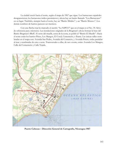
- Page 140 and 141: La cabecera municipal, Bilwi o Puer
- Page 142 and 143: En el informe no hay ninguna menci
- Page 146 and 147: a net loss of $1,184.64 on Nos. 1,
- Page 148 and 149: the heavy rains which prevent them
- Page 150 and 151: done, with the exception of the las
- Page 152 and 153: Editado por Alfredo Kirkland Recuer
- Page 154 and 155: vos quemándolos delante de ellos,
- Page 156 and 157: Al regresar a sus dominios, el ahor
- Page 158 and 159: orado en la contienda por la reinco
- Page 160 and 161: esultaba muy interesante se quedaba
- Page 162 and 163: un incendio; sus tañidos lloraban
- Page 164 and 165: islas. Divisé claramente la iglesi
- Page 166 and 167: nos del Colegio Moravo: el Prof. Li
- Page 168 and 169: aban el fluido eléctrico, podían
- Page 170 and 171: No sé ni corno se corrió la voz,
- Page 172 and 173: Registro del Estado Civil de las Pe
- Page 174 and 175: Libro de Matrimonios,1883. Página
- Page 176 and 177: “El 8 de marzo de 1894 contrajo m
- Page 178 and 179: José Benito Rosales, abogado y Jue
- Page 180 and 181: Los hechos obtenidos de esos docume
- Page 182 and 183: Página sin número. Partida 8 En M
- Page 184 and 185: Matrimonios 1931. Pagina 119. Parti
- Page 186 and 187: En Managua, a tres de Abril de mil
- Page 188 and 189: Esta creencia tradicional de los Su
- Page 190 and 191: Este cuento, que refleja las ideas
- Page 192 and 193: o "tonto", compañero de la antigua
- Page 194 and 195:
LAKIATARA: (Lakia Tara): Líder leg
- Page 196 and 197:
WALAX: Árbol fructífero de la fam
- Page 198 and 199:
música campesina. Como ven aquí n
- Page 200 and 201:
Después de recorrer unos 22 kilóm
- Page 202 and 203:
Siendo ya pareja bajo la unión de
- Page 204 and 205:
5.1. El movimiento sindical campesi
- Page 206 and 207:
alimentar a su familia. Pues ese sa
- Page 208 and 209:
El sindicalismo campesino de La Tro
- Page 210 and 211:
lo más pronto posible, para dar a
- Page 212 and 213:
LA REFLEXIÓN No importa cuáles ha
- Page 214 and 215:
En el campo, no todo era reclamos,
- Page 216 and 217:
El papá de los Valenzuela, don Te
- Page 218 and 219:
flicto por la tenencia de la tierra
- Page 220 and 221:
Esos elementos se empezaron a manif
- Page 222 and 223:
Desde el año de 1963 se venía pro
- Page 224 and 225:
Bernardino comprendió que “la lu
- Page 226 and 227:
tierra. La acción de protestar por
- Page 228 and 229:
Miembros: Filadelfo Díaz Ochoa (he
- Page 230 and 231:
Jurisdicción del sindicato: Castil
- Page 232 and 233:
Diario La Prensa: 30 de noviembre d
- Page 234 and 235:
LIBRO DEL MES El Negocio de Somoza
- Page 236 and 237:
En Corinto, la infraestructura ya e
- Page 238 and 239:
Honorable Cámara: Es en estos mome