estructura gravimétrica y magnética de la corteza del suroeste ...
estructura gravimétrica y magnética de la corteza del suroeste ...
estructura gravimétrica y magnética de la corteza del suroeste ...

You also want an ePaper? Increase the reach of your titles
YUMPU automatically turns print PDFs into web optimized ePapers that Google loves.
Nieves Sánchez Jiménez<br />
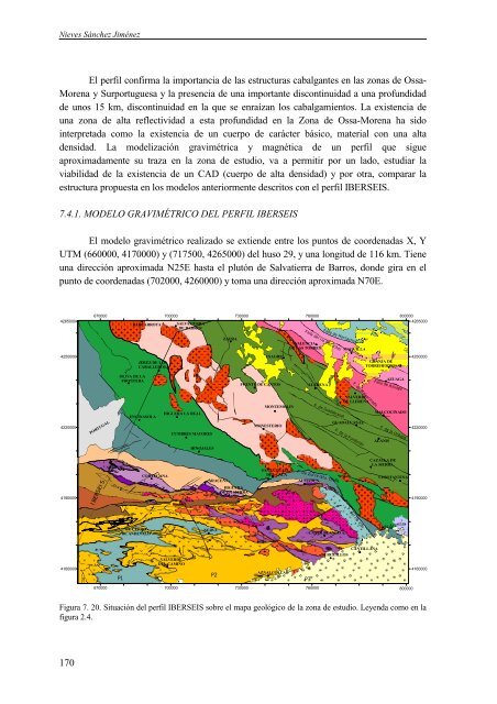
El perfil confirma <strong>la</strong> importancia <strong>de</strong> <strong>la</strong>s <strong>estructura</strong>s cabalgantes en <strong>la</strong>s zonas <strong>de</strong> Ossa-<br />
Morena y Surportuguesa y <strong>la</strong> presencia <strong>de</strong> una importante discontinuidad a una profundidad<br />
<strong>de</strong> unos 15 km, discontinuidad en <strong>la</strong> que se enraízan los cabalgamientos. La existencia <strong>de</strong><br />
una zona <strong>de</strong> alta reflectividad a esta profundidad en <strong>la</strong> Zona <strong>de</strong> Ossa-Morena ha sido<br />
interpretada como <strong>la</strong> existencia <strong>de</strong> un cuerpo <strong>de</strong> carácter básico, material con una alta<br />
<strong>de</strong>nsidad. La mo<strong>de</strong>lización <strong>gravimétrica</strong> y <strong>magnética</strong> <strong>de</strong> un perfil que sigue<br />
aproximadamente su traza en <strong>la</strong> zona <strong>de</strong> estudio, va a permitir por un <strong>la</strong>do, estudiar <strong>la</strong><br />
viabilidad <strong>de</strong> <strong>la</strong> existencia <strong>de</strong> un CAD (cuerpo <strong>de</strong> alta <strong>de</strong>nsidad) y por otra, comparar <strong>la</strong><br />
<strong>estructura</strong> propuesta en los mo<strong>de</strong>los anteriormente <strong>de</strong>scritos con el perfil IBERSEIS.<br />
7.4.1. MODELO GRAVIMÉTRICO DEL PERFIL IBERSEIS<br />
El mo<strong>de</strong>lo gravimétrico realizado se extien<strong>de</strong> entre los puntos <strong>de</strong> coor<strong>de</strong>nadas X, Y<br />
UTM (660000, 4170000) y (717500, 4265000) <strong>de</strong>l huso 29, y una longitud <strong>de</strong> 116 km. Tiene<br />
una dirección aproximada N25E hasta el plutón <strong>de</strong> Salvatierra <strong>de</strong> Barros, don<strong>de</strong> gira en el<br />
punto <strong>de</strong> coor<strong>de</strong>nadas (702000, 4260000) y toma una dirección aproximada N70E.<br />
4265000<br />
4250000<br />
4220000<br />
4190000<br />
4160000<br />
170<br />
670000 700000 730000 760000 800000<br />
BARCARROTA SALVATIERRA<br />
DE BARROS<br />
4265000<br />
PORTUGAL<br />
IBERSEIS<br />
AROCHE<br />
OLIVA DE LA<br />
FRONTERA<br />
EL CERRO<br />
DE ANDEVALO<br />
P1<br />
JEREZ DE LOS<br />
CABALLEROS<br />
ENCINASOLA<br />
CORTEGANA<br />
HIGUERA LA REAL<br />
CUMBRES MAYORES<br />
VALVERDE<br />
DEL CAMINO<br />
HINOJALES<br />
ARACENA<br />
NERVA<br />
AZNALCOLLAR<br />
VALENCIA<br />
DE LAS TORRES<br />
ALMADEN<br />
670000 700000 730000 760000<br />
P2<br />
ZAFRA<br />
HIGUERA<br />
DE LA SIERRA<br />
USAGRE<br />
FUENTE DE CANTOS<br />
MONTEMOLIN<br />
MONESTERIO<br />
SANTA OLALLA<br />
DEL CALA<br />
LLERENA<br />
Fal<strong>la</strong> <strong>de</strong> Hornachos<br />
Fal<strong>la</strong> <strong>de</strong>l río Matachel<br />
F. <strong>de</strong> Guadalcanal<br />
F. De Zufre-Sta. O<strong>la</strong>l<strong>la</strong><br />
CASTILBLANCO A.<br />
MAGUILLA<br />
VALVERDE<br />
DE LLERENA<br />
GUADALCANAL<br />
F. <strong>de</strong> <strong>la</strong> Fundición<br />
F. <strong>de</strong> Malcocinado<br />
CANTILLANA<br />
BURGUILLOS<br />
GRANJA DE<br />
TORREHERMOSA<br />
MALCOCINADO<br />
ALANIS<br />
AZUAGA<br />
Fal<strong>la</strong> <strong>de</strong> Azuaga<br />
F. <strong>de</strong> <strong>la</strong> Urbana<br />
CAZALLA DE<br />
LA SIERRA<br />
CONSTANTINA<br />
F. <strong>de</strong> Arenil<strong>la</strong>s<br />
Figura 7. 20. Situación <strong>de</strong>l perfil IBERSEIS sobre el mapa geológico <strong>de</strong> <strong>la</strong> zona <strong>de</strong> estudio. Leyenda como en <strong>la</strong><br />
figura 2.4.<br />
P3<br />
F. <strong>de</strong>l río Viar<br />
800000<br />
4250000<br />
4220000<br />
4190000<br />
4160000