V. Zaldo et al.REFERENCIASANDERSON, G. L., HANSON, J. D. & HAAS, R.H. 1993. Evaluating Landsat Thematic Mapper <strong>de</strong>rivedvegetation indices for estimating abovegroundbiomass on semiarid rangelands. RemoteSensing of Environment, 45, 165-175.AXELSSON, P. 1999. Processing of laser scanner data;algorithms and applications. ISPRS Journal ofPhotogrammetry & Remote Sensing, 54: 138-147.BAULIES, X. & PONS, X. 1995. Approach to forestryinventory and mapping by means of multispectralairborne data. International Journal of RemoteSensing, 16: 61-80.BURRIEL, J. A., GRACIA, C., IBÀÑEZ, J. J., MA-TA, T. & VAYREDA, J. 2000-2004. Inventari Ecològici Forestal <strong>de</strong> Catalunya (IEFC). CREAF, Bellaterra.CHEN, Q., BALDOCCHI, D. D., GONG, P. &KELLY, M. 2006. Isolating individual trees in a savannawoodland using small footprint LiDAR data.Photogrammetric Engineering and Remote Sensing,72: 923-932.CHEN, Q., GONG, P., BALDOCCHI, D. & TIAN, Y.2007. Estimating basal area and stem volume forindividual trees from LiDAR data . Photogrammetricengineering and Remote Sensing, 12: 1355-1365.GARCIA, M., RIANO, D., CHUVIECO, E. & DAN-SON, FM. 2010. Estimating biomass carbon stocksfor a Mediterranean forest in central Spain usingLiDAR height and intensity data. Remote Sensingof Environment, 114: 816-830.GRACIA, C., BURRIEL, J. A., IBÀÑEZ, J. J., MA-TA, T. & VAYREDA, J. 2004. InventariEcològic i Forestal <strong>de</strong> Catalunya. Mèto<strong>de</strong>s. Volum9. CREAF, Bellaterra, 112.HILL, R. & THOMSON, A. 2005. Mapping woodlandspecies composition and structure using airbornespectral and LiDAR data. International Journalof Remote Sensing, 26: 3763-3779.MALLINIS, G., KOUTSIAS, N., MAKRAS, A. &KARTERIS, M. 2004 Forest parameters estimationin a European Mediterranean landscape using remotelysensed data . Forest Science, 50: 450-460.MASELLI, F. & CHIESI, M. 2006. Evaluation of StatisticalMethods to Estimate Forest Volume in a MediterraneanRegion. IEEE Transactions on Geoscienceand Remote Sensing, 44: 2239-2250.NAESSET, E. 1997. Determination of mean treeheight of forest stands using airborne laser scannerdata. Journal of Photogrammetry and RemoteSensing, 52: 49-56.NELSON, R., ODERWALD, R. & GREGOIRE, T. G.1997. Separating the ground and airborne lasersampling phases to estimate tropical forest basalarea, volume, and biomass. Remote Sensing of Environment,60: 311-326.NIJLAND, W., ADDINK, E. A., DE JONG, S. M. &VAN DER MEER, F. D. 2009. Optimizing spatialimage support for quantitative mapping of naturalvegetation. Remote Sensing of Environment,13:771-780.PONS, X. 2010. MiraMon. Geographical informationsystem and remote sensing software. Versión 7.Centre <strong>de</strong> Recerca Ecològica i Aplicacions Forestals(CREAF). ISBN: 84-931323-4-9.POPESCU, S. C., WYNNE R. H. & NELSON R.F.2003. Measuring individual tree crown diameterwith lidar and assessing its influence on estimatingforest volume and biomass. Canadian Journal ofRemote Sensing, 29: 564-577.RIAÑO, D., CHUVIECO, E., CONDES, S., GONZÁ-LEZ-MATESANZ, J. & USTIN, S. 2004. Generationof crown bulk <strong>de</strong>nsity for Pinus sylvestris L.from LiDAR. Remote Sensing of Environment, 92:345-352.RIAÑO, D., MEIER, E., ALLGÖWER, B., CHUVIE-CO, E. & USTIN, S. L. 2003. Mo<strong>de</strong>ling airbornelaser scanning data for the spatial generation of criticalforest parameters in fire behavior mo<strong>de</strong>ling.Remote Sensing of Environment, 86: 177-186.RODRÍGUEZ, J. P., BROTONS, L., BUSTAMANTE,J. & SEOANE, J. 2007. The application of predictivemo<strong>de</strong>lling of species distribution to biodiversityconservation. Diversity and Distributions, 13:243-251.SALVADOR, R. & PONS, X. 1998. On the applicabilityof Landsat TM images to Mediterranean forestinventories. Forest Ecology and Management,104: 193-208.SALVADOR, R., PONS, X. & BAULIES, X. 1997.Análisis <strong>de</strong> imágenes multiespectrales aerotransportadaspara estimar variables estructurales <strong>de</strong>bosques mediterráneos <strong>de</strong> Quercus ilex L. Orsis,12: 127-139.SCHLERF, M. & ATZBERGER, C. 2006. Inversionof a forest reflectance mo<strong>de</strong>l to estimate structuralcanopy variables from hyperspectral remote sensingdata. Remote Sensing of Environment, 100:281-294.VÁZQUEZ DE LA CUEVA, A. 2008. Structural attributesof three forest types in central Spain andLandsat ETM plus information evaluated with redundancyanalysis. International Journal of RemoteSensing, 29: 5657-5676.WEHR, A. & LOHR, U. 1999. Airborne laser scanning- an introduction and overview. ISPRS Journalof Photogrammetry & Remote Sensing, 54: 68-82.ZIEGLER, M., KONRAD, H., HOFRICHTER, J.,WIMMER, A., RUPPERT, G., SCHARDT, M. &HYYPPA, J. 2000. Assessment of forest attributesand single-tree segmentation by means of laserscanning. Proceedings of the Internacional Societyfor Optical Engineering, 4035: 73-84.64 Revista <strong>de</strong> Tele<strong>de</strong>tección. ISSN: 1988-8740. 2010. 34: 55-68
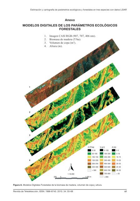
Estimación y cartografía <strong>de</strong> parámetros ecológicos y forestales en tres especies con datos LiDARAnexoMODELOS DIGITALES DE LOS PARÁMETROS ECOLÓGICOSFORESTALES1. Imagen CASI RGB (907, 707, 406 nm).2. Biomasa <strong>de</strong> ma<strong>de</strong>ra (T/ha).3. Volumen <strong>de</strong> copa (m 3 ).4. Altura (m).12342 (T/ha)0-5050-100100-150150-200N200-250250-300> 3001:16.000200 0 1.000 m3 (m 3 ) 4 (m)0-100 0-5100-200 5-10200-300 10-15300-400 15-20400-500 20-25500-600 25-30600-700 30-35700-800 >35> 800Figura A. Mo<strong>de</strong>los Digitales Forestales <strong>de</strong> la biomasa <strong>de</strong> ma<strong>de</strong>ra, volumen <strong>de</strong> copa y altura.Revista <strong>de</strong> Tele<strong>de</strong>tección. ISSN: 1988-8740. 2010. 34: 55-68 65