REVISTADE TELEDETECCIÃN - Asociación Española de ...
REVISTADE TELEDETECCIÃN - Asociación Española de ...
REVISTADE TELEDETECCIÃN - Asociación Española de ...

You also want an ePaper? Increase the reach of your titles
YUMPU automatically turns print PDFs into web optimized ePapers that Google loves.
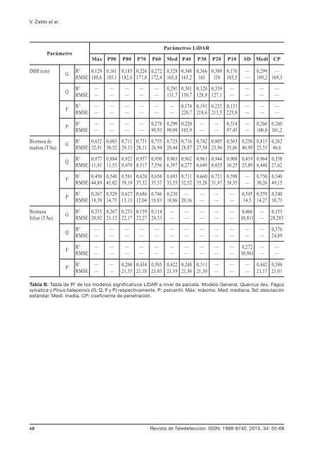
V. Zaldo et al.ParámetroParámetros LiDARMáx P90 P80 P70 P60 Med P40 P30 P20 P10 SD Medi CPDBH (cm)GQFPR 2 0,129 0,161 0,185 0,226 0,272 0,328 0,348 0,366 0,389 0,176 — 0,299 —RMSE 188,6 185,1 182,4 177,8 172,4 165,8 163,2 161 158 183,5 — 169,2 169,3R 2 — — — — — 0,291 0,301 0,320 0,339 — — — —RMSE — — — — — 131,7 130,7 128,9 127,1 — — — —R 2 — — — — — — 0,174 0,191 0,233 0,131 — — —RMSE — — — — — — 220,7 218,6 213,5 225,8 — — —R 2 — — — — 0,278 0,290 0,220 — — 0,314 — 0,266 0,260RMSE — — — — 99,93 99,09 103,9 — — 97,45 — 100,8 101,2Biomasa <strong>de</strong>RG2 0,632 0,683 0,711 0,731 0,753 0,725 0,716 0,742 0,805 0,563 0,250 0,815 0,262ma<strong>de</strong>ra (T/ha) RMSE 32,91 30,52 29,13 28,11 26,94 28,44 28,87 27,54 23,94 35,86 46,99 23,35 46,6QFPR 2 0,877 0,884 0,922 0,937 0,950 0,963 0,962 0,961 0,944 0,908 0,419 0,964 0,338RMSE 11,91 11,53 9,479 8,517 7,556 6,397 6,277 6,649 8,035 10,25 25,89 6,448 27,62R 2 0,450 0,540 0,581 0,620 0,658 0,693 0,711 0,660 0,721 0,598 — 0,750 0,340RMSE 44,89 41,02 39,19 37,32 35,37 33,55 32,52 35,28 31,97 38,35 — 30,26 49,15R 2 0,267 0,529 0,627 0,686 0,746 0,230 — — — — 0,545 0,559 0,240RMSE 18,39 14,75 13,13 12,04 10,83 18,86 20,16 — — — 14,5 14,27 18,73BiomasaRG2 0,335 0,267 0,233 0,159 0,114 — — — — — 0,466 — 0,153foliar (T/ha) RMSE 20,02 21,12 22,17 22,27 24,33 — — — — — 10,811 — 28,283QFPR 2 — — — — — — — — — — — — 0,376RMSE — — — — — — — — — — — — 24,89R 2 — — — — — — — — — — 0,272 — —RMSE — — — — — — — — — — 30,961 — —R 2 — — 0,260 0,434 0,585 0,422 0,248 0,311 — — — 0,442 0,586RMSE — — 21,35 21,18 21,03 21,19 21,36 21,30 — — — 21,17 21,01Tabla B. Tabla <strong>de</strong> R 2 <strong>de</strong> los mo<strong>de</strong>los significativos LiDAR a nivel <strong>de</strong> parcela. Mo<strong>de</strong>lo General, Quercus ilex, Fagussylvatica y Pinus halepensis (G, Q, F y P) respectivamente. P: percentil. Máx: máximo. Med: mediana. Sd: <strong>de</strong>sviaciónestándar. Medi: media. CP: coeficiente <strong>de</strong> penetración.68 Revista <strong>de</strong> Tele<strong>de</strong>tección. ISSN: 1988-8740. 2010. 34: 55-68