- Page 1 and 2:
T Working Knowledge: local ecologic
- Page 3 and 4:
CONTENTS Acknowledgments ..........
- Page 5 and 6:
5 Working knowledge: Conclusions an
- Page 7 and 8:
Figure 29. Mitchell catchment in fl
- Page 9 and 10:
Figure 68. 2004 Aerial Photograph o
- Page 11 and 12:
ACKNOWLEDGMENTS The project is the
- Page 13 and 14:
EXECUTIVE SUMMARY This is a report
- Page 15 and 16:
space for a complementary study emp
- Page 17 and 18:
cattlemen and the Hughes family, th
- Page 19 and 20:
As a contrast and complement, it is
- Page 21 and 22:
of people residing there during the
- Page 23 and 24:
the area for one or two seasons, bu
- Page 25 and 26:
Fire Frequency: for the Oriners are
- Page 27 and 28:
Strang then describes the story of
- Page 29 and 30:
emembered linguistic associations.
- Page 31 and 32:
Mystical/spiritual Scientific Perso
- Page 33 and 34:
ut your children will probably get
- Page 35 and 36:
20 years, Cecil Hughes, the son of
- Page 37 and 38:
Robert Burns: I was walking around
- Page 39 and 40:
Corporation. 12 Viv Sinnamon provid
- Page 41 and 42:
The purchase process was a factor i
- Page 43 and 44:
Viv Sinnamon: Yeah, and when we had
- Page 45 and 46:
communities, Lockhardt [River] and
- Page 47 and 48:
1.7 Oriners and the contemporary re
- Page 49 and 50:
management of country are not new.
- Page 51 and 52:
The above points demonstrate the va
- Page 53 and 54:
about forest and think of something
- Page 55 and 56:
Marcus Barber: Is that where Kowany
- Page 57 and 58:
-----------------------------------
- Page 59 and 60:
comes along with that, and where th
- Page 61 and 62:
Ivan Jimmy‟s brother Wilfred made
- Page 63 and 64:
Indigenous Australians are renowned
- Page 65 and 66:
Colin Hughes followed up his though
- Page 67 and 68:
Ezra Michael: I never heard it. No.
- Page 69 and 70:
Marcus Barber: So every time you we
- Page 71 and 72:
Figure 20. Oriners Lagoon in flood
- Page 73 and 74:
Figure 23. Large Woody Debris (LWD)
- Page 75 and 76:
Figure 24. Jeff Shellberg talks wit
- Page 77 and 78:
Figure 27. Mitchell catchment in fl
- Page 79 and 80:
2.2.4 Permanent water and groundwat
- Page 81 and 82:
Marcus Barber: So do you know how d
- Page 83 and 84:
Marcus Barber: Does that happen at
- Page 85 and 86:
Marcus Barber: What animals do you
- Page 87 and 88:
people are using the lagoon. Becaus
- Page 89 and 90:
that old black headed python. You g
- Page 91 and 92:
Marcus Barber: I was trying to find
- Page 93 and 94:
Major introduced animals at Oriners
- Page 95 and 96:
Colin Hughes: Oh there‟s just a l
- Page 97 and 98:
There was never too many [wild hors
- Page 99 and 100:
Cecil Hughes: Yes, you never saw th
- Page 101 and 102:
And they had special fish traps her
- Page 103 and 104: Philip Yam: 3 or 4 times. A few tim
- Page 105 and 106: Conversations with Philip Yam about
- Page 107 and 108: Marcus Barber: so you have to get f
- Page 109 and 110: 2.5.4 Cattlemen: working connection
- Page 111 and 112: Edwin David Most of the older build
- Page 113 and 114: spirits being reborn in new generat
- Page 115 and 116: Marcus Barber: Phillip‟s son Max?
- Page 117 and 118: necessary at some of the times they
- Page 119 and 120: Marcus Barber: If it was a really w
- Page 121 and 122: hobble the horse and camp out there
- Page 123 and 124: Marcus Barber: So you were moving a
- Page 125 and 126: Marcus Barber: Was the grass still
- Page 127 and 128: Philip Yam: Drumduff. We got blamed
- Page 129 and 130: purpose of fires needs to be very c
- Page 131 and 132: Marcus Barber: But it‟s been ther
- Page 133 and 134: Figure 38. Oriners station from the
- Page 135 and 136: and it traverses some areas prone t
- Page 137 and 138: 2.7.1 Applying „Working Knowledge
- Page 139 and 140: ochen (uy -) ojen (uy -) mujun (uy
- Page 141 and 142: Oykangand Olkol Og Water ok Water o
- Page 143 and 144: Other signs mark a broader seasonal
- Page 145 and 146: The two comments from the Jimmy bro
- Page 147 and 148: Average Monthly Rainfall (mm)_ 450
- Page 149 and 150: demonstrated that cyclone landing f
- Page 151 and 152: Figure 48. Geology of the catchment
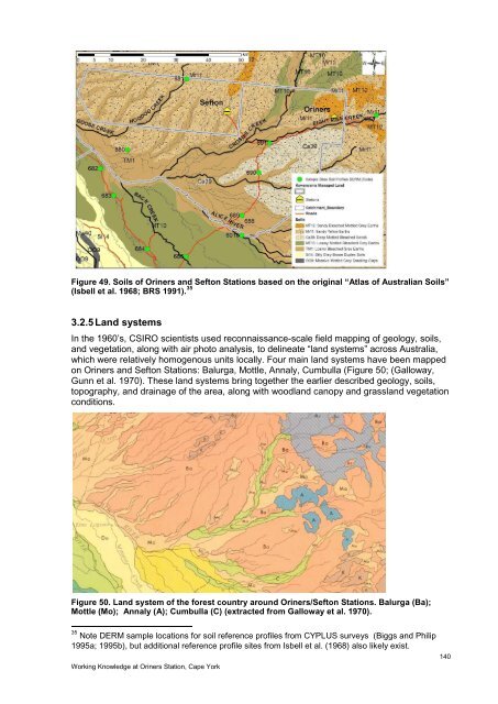
- Page 153: 3.2.4 Soils The soils of the “for
- Page 157 and 158: Figure 52. RAAF oblique photograph
- Page 159 and 160: Annaly (A) Land System Lowlands on
- Page 161 and 162: 3.2.6 Soil erosion Soil erosion can
- Page 163 and 164: Figure 56. Land use map of the Mitc
- Page 165 and 166: larger valleys of Hoodoo and Sellar
- Page 167 and 168: solutes from subsurface sedimentary
- Page 169 and 170: 3.2.10.2 Eight Mile valley near Ori
- Page 171 and 172: Elevation (m) 180 160 140 120 100 8
- Page 173 and 174: Figure 64. 1955 Aerial Photograph o
- Page 175 and 176: pools like these are typically carv
- Page 177 and 178: Figure 67. 1955 Aerial Photograph O
- Page 179 and 180: Working Knowledge at Oriners Statio
- Page 181 and 182: have also been defined as valley-bo
- Page 183 and 184: Working Knowledge at Oriners Statio
- Page 185 and 186: Working Knowledge at Oriners Statio
- Page 187 and 188: Eucalyptus leptophleba (Mollow Red
- Page 189 and 190: to manage vegetation and game, or f
- Page 191 and 192: Figure 77. 1955 aerial photograph o
- Page 193 and 194: Overall pig populations are poorly
- Page 195 and 196: area can be obtained from the Queen
- Page 197 and 198: degradation. Genuine restoration op
- Page 199 and 200: Section 4.1 contains models of inte
- Page 201 and 202: Figure 80. Model of Oriners landsca
- Page 203 and 204: 4.1.3 Late dry season Two key diffe
- Page 205 and 206:
eshape the elements in the same way
- Page 207 and 208:
Evidence from Section 2.6.4 and 3.2
- Page 209 and 210:
Working Knowledge at Oriners Statio
- Page 211 and 212:
Figure 92. Oblique air photos of Ho
- Page 213 and 214:
The primary contexts for learning k
- Page 215 and 216:
Despite data limitation, there is e
- Page 217 and 218:
Marcus Barber: If you were to think
- Page 219 and 220:
Regional scale Neighbouring Statio
- Page 221 and 222:
Cotter, G. (1995). A study of the p
- Page 223 and 224:
Kowanyama Aboriginal Council (2003)
- Page 225 and 226:
Smart, J., K. G. Grimes, et al. (19
- Page 227 and 228:
7 GLOSSARY 38 Alkaline- having the
- Page 229 and 230:
Fluvial Megafan- a large (10 3 -10
- Page 231 and 232:
Potential Energy- the stored energy
- Page 233 and 234:
8 APPENDICES 8.1 Informed Consent F
- Page 235 and 236:
8.3 Wildlife Animal Species List fo
- Page 237 and 238:
Birds Coraciidae Eurystomus orienta
- Page 239 and 240:
Reptiles Crocodylidae Crocodylus jo
- Page 241 and 242:
Dicots Fabaceae Crotalaria montana
- Page 243 and 244:
Dicots Myrtaceae Neofabricia serici
- Page 245 and 246:
Monocots Poaceae Eriachne sp. C Mon
- Page 247:
Working Knowledge at Oriners Statio