

WfHC - cover page (not to be used with pre-printed report ... - CSIRO
WfHC - cover page (not to be used with pre-printed report ... - CSIRO
WfHC - cover page (not to be used with pre-printed report ... - CSIRO

Create successful ePaper yourself
Turn your PDF publications into a flip-book with our unique Google optimized e-Paper software.
esearcher (Strang 2001) foc<strong>used</strong> on cultural mapping of the area <strong>be</strong>tween the Alice-Crosbie<br />
junction and Oriners and <strong>not</strong>ed the singularity of this landscape and its value <strong>to</strong> its traditional<br />
inhabitants:<br />
The Alice-Crosbie area is characterised by major river and creek systems, and floods<br />
extensively in the wet season, although high ridges above the rivers provide sanctuary from<br />
the floodwaters. At the time of the mapping project, an unusually long wet had left much of<br />
the country boggy and inaccessible <strong>to</strong> vehicles, and many of the deep creeks were still<br />
flowing. Even in mid `dry' season, there were spring flowers and green grass, and the big<br />
swamps were teeming <strong>with</strong> wildlife. It was clear that, for hunter-gatherers, such country<br />
would have offered a huge and unusually reliable range of resources. Even in the driest of<br />
seasons there are springs which never run dry; there are major populations of birds, fish<br />
and animals; a wide array of edible and medicinal plants and fruits, and materials for<br />
traditional artefacts. The Kunjen elders descri<strong>be</strong>d regular patterns of movement around the<br />
area, and <strong>not</strong>ed many long-term camp sites, where people lived even when some<br />
mem<strong>be</strong>rs of their communities <strong>be</strong>came involved in work on the cattle stations. Being some<br />
distance from any major settlements, people could continue their traditional practices<br />
relatively undistur<strong>be</strong>d, and Kunjen elders recall their families living in „cus<strong>to</strong>m ways' well<br />
in<strong>to</strong> this century. Even after several families made a base at the station homestead at<br />
Koolatah, they still walked back <strong>to</strong> this area <strong>to</strong> make use of their land.<br />
(Strang 2001: 1)<br />
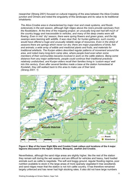
Figure 4. Map of the lower Eight Mile and Crosbie Creek valleys and locations of the 4 major<br />
lagoons discussed in the <strong>report</strong>: Oriners, Mosqui<strong>to</strong>, Jewfish and Crosbie.<br />
Nevertheless, although the sand ridge areas are slightly higher, like the rest of the station<br />
they remain soft during the wet season and are difficult for vehicles and heavy, hard hoofed<br />
animals such as cattle <strong>to</strong> negotiate. The soft and boggy ground, regular flooding regime, poor<br />
nutrition available <strong>to</strong> s<strong>to</strong>ck in the large areas of more sparsely vegetated ti tree woodlands<br />
and sand ridges mean that the station is <strong>not</strong> rich cattle country. It has therefore remained<br />
largely unfenced and has never had high s<strong>to</strong>cking rates. It also did <strong>not</strong> have large num<strong>be</strong>rs<br />
Working Knowledge at Oriners Station, Cape York<br />
5


