WfHC - cover page (not to be used with pre-printed report ... - CSIRO
WfHC - cover page (not to be used with pre-printed report ... - CSIRO
WfHC - cover page (not to be used with pre-printed report ... - CSIRO
Create successful ePaper yourself
Turn your PDF publications into a flip-book with our unique Google optimized e-Paper software.
management implementation. The new park will require additional resources and <strong>pre</strong>sence<br />
by Olkol people in an area which is close <strong>to</strong> Oriners by road, enhancing both access <strong>to</strong> and<br />
the significance of the infrastructure at Oriners.<br />
Yet of likely greater longer term significance <strong>to</strong> Oriners and its people is that a num<strong>be</strong>r of<br />
other stations in the region around Oriners are part of the CYPAL process, al<strong>be</strong>it at earlier<br />
stages of negotiation. These include the directly adjacent stations of Crosbie, Wulpan, and<br />
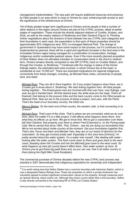
Dixie, as well as the nearby stations of Strathmay and Glen Garland (Figure 3). Pending<br />
further negotiations about the divisions of land <strong>be</strong>tween the two CYPAL land categories and<br />
their boundaries in each case, the expectation is that each of these properties should <strong>be</strong><br />
approximately 50% Indigenous land, 50% co-managed National Park. The change of<br />
government in Queensland may have some impact on the process, but if it continues <strong>to</strong> <strong>be</strong><br />
implemented as planned, there will <strong>be</strong> a rapid and significant increase in the land area in the<br />
immediate Oriners region <strong>be</strong>ing managed for a combination of conservation, heritage,<br />
Indigenous and/or sustainable pas<strong>to</strong>ral values. Even if the more recently planned acquisition<br />
of Dixie Station does <strong>not</strong> ultimately transition <strong>to</strong> conservation lands in the short <strong>to</strong> medium<br />
term, Oriners remains directly connected <strong>to</strong> new NP (CYPAL) land on Crosbie Station, and<br />
through the Crosbie, <strong>to</strong> Strathmay. 16 Combined <strong>with</strong> the change in status of the former<br />
Kalinga station, the estimated land area involved, in which Oriners lies at the heart, is<br />
substantial at over 10,000 km 2 . There are important implications for regional Indigenous<br />
connectivity from these changes, including, as Michael Ross <strong>not</strong>es, connectivity of people,<br />
land, and water:<br />
Michael Ross: They are all in there <strong>to</strong>gether. So if any project happens down there, we in<br />
Crosbie got <strong>to</strong> know about it. Strathmay. We start linking <strong>to</strong>gether then. All tribal people<br />
linking <strong>to</strong>gether…The Kowanyama mob are involved <strong>with</strong> that over here, over Kalinga. Last<br />
year we got it handed back. All that cleared area, the white area [on the map]. That‟s all<br />
freehold, that <strong>be</strong>long <strong>to</strong> the possum tri<strong>be</strong> and the back country come <strong>to</strong> the Olkol people as<br />
National Park. Now we are in the process of doing a project, next year, <strong>with</strong> the Parks.<br />
That‟s the head of our boundary country, the tribal one.<br />
Marcus Bar<strong>be</strong>r: So the back end of that country, the western side, is that connecting in <strong>to</strong><br />
Oriners?<br />
Michael Ross: That‟s part of the chain. That is where we are connected, what we do over<br />
here, does <strong>not</strong> matter if it is a little project, it still affects what happens down there. And<br />
what they do affects us up here. We got <strong>to</strong> know that. We‟ve got a corporation over there,<br />
[at] Glen Garland, that property over there is where Fred [Coleman] is, on the Pormpuraaw<br />
road. We‟ve owned that since 1993. That, Oriners…see we are doing our boundaries first.<br />
We‟re <strong>not</strong> worried about inside country at the moment. Get your boundaries <strong>to</strong>gether first.<br />
That‟s why Trevor and them and Michael Yam, they are on our board of direc<strong>to</strong>rs for the<br />
corporation. So they get involved <strong>pre</strong>tty well. Especially in this area here [Oriners], I‟m<br />
<strong>pre</strong>tty worried about the water system. I‟m a water man myself, I like dealing <strong>with</strong> water -<br />
looking after the water system. This flush come down <strong>to</strong> there and goes back <strong>to</strong> the west<br />
coast, [heading down the Crosbie and in<strong>to</strong> the Mitchell] goes back <strong>to</strong> the west coast. So<br />
what happens up here [at Laura] doesn‟t affect there. Own water system up here. At<br />
Oriners you‟ve got these big peak flows and, as you can see, that is all water country in<br />
there [along the Eight Mile Creek floodplain].<br />
The commercial purchase of Oriners decades <strong>be</strong>fore the new CYPAL land process was<br />
enacted in 2007 demonstrates that Indigenous aspirations for ownership and independent<br />
16 It is worth <strong>not</strong>ing here that Sef<strong>to</strong>n Station has a common boundary <strong>with</strong> Harkness Station, which is<br />
now a designated Nature Refuge Area. These are properties on which a private landowner has<br />
voluntarily agreed <strong>to</strong> protect significant conservation values on the property, through measures such<br />
as riparian fencing, weed control, etc. Although they share a point rather than a line boundary, Sef<strong>to</strong>n<br />
is also directly connected <strong>to</strong> the impending NP (CYPAL) on Crosbie Station.<br />
Working Knowledge at Oriners Station, Cape York<br />
33


