Mitigation for the Construction and Operation of Libby Dam
Mitigation for the Construction and Operation of Libby Dam
Mitigation for the Construction and Operation of Libby Dam

Create successful ePaper yourself
Turn your PDF publications into a flip-book with our unique Google optimized e-Paper software.
70<br />
60<br />
50<br />
40<br />
30<br />
20<br />
10<br />
0 500 1000 1500 2000 2500 3000<br />
Pr<strong>of</strong>ile Distance (ft)<br />
0<br />
Elevation (ft)<br />
2002 2003<br />
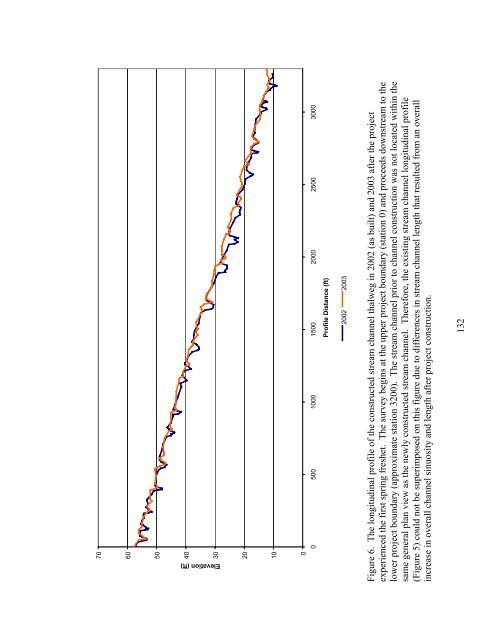
Figure 6. The longitudinal pr<strong>of</strong>ile <strong>of</strong> <strong>the</strong> constructed stream channel thalweg in 2002 (as built) <strong>and</strong> 2003 after <strong>the</strong> project<br />
experienced <strong>the</strong> first spring freshet. The survey begins at <strong>the</strong> upper project boundary (station 0) <strong>and</strong> proceeds downstream to <strong>the</strong><br />
lower project boundary (approximate station 3200). The stream channel prior to channel construction was not located within <strong>the</strong><br />
same general plan view as <strong>the</strong> newly constructed stream channel. There<strong>for</strong>e, <strong>the</strong> existing stream channel longitudinal pr<strong>of</strong>ile<br />
(Figure 5) could not be superimposed on this figure due to differences in stream channel length that resulted from an overall<br />
increase in overall channel sinuosity <strong>and</strong> length after project construction.<br />
132