- Page 4: Validity of this manualDescriptionG
- Page 8 and 9: Shipping ..........................
- Page 10: Special features• Easy and quickl
- Page 17 and 18: Power SupplyUse the Leica Geosystem
- Page 19 and 20: Fixed keys[PAGE] Scrolls to next pa
- Page 21 and 22: Incorrect resultReflectorlessBe sur
- Page 23 and 24: SoftkeysUnder softkeys, a selection
- Page 25 and 26: Menu tree[MENU] > - Confirm menu se
- Page 27 and 28: Inserting / Replacing Battery2. Rem
- Page 29 and 30: External power supply for totalstat
- Page 31 and 32: Careful handling of tripod• Check
- Page 33 and 34: Levelling up with the electronic le
- Page 35 and 36: Input mode - method 1In entry mode,
- Page 37 and 38: Inserting charactersIf a character
- Page 39 and 40: Character setEntry mode contains th
- Page 41 and 42: Wildcard searchThe Wildcard search
- Page 43 and 44: FNC KeyUnder [FNC] several function
- Page 45 and 46: Enter offset values!Trav. Offset: 0
- Page 47 and 48: 5 [ALL] Completes the measurement a
- Page 49: Procedure:1. Measure to first prism
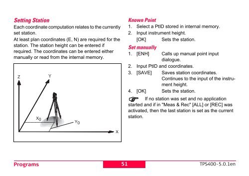
- Page 53 and 54: Orientation coordinates can be eith
- Page 55 and 56: Useful information• If the orient
- Page 57 and 58: SurveyingWith the program Surveying
- Page 59 and 60: Orthogonal Stake outThe position of
- Page 61 and 62: Measuring facilitiesSingle face I o
- Page 63 and 64: [AddPt] Input another backsight poi
- Page 65 and 66: [Disable]/[Enable]Excludes/includes
- Page 67 and 68: Reference LineThis program facilita
- Page 69 and 70: REFERENCE LINE - MAIN 1/2Length : 1
- Page 71 and 72: Example "relative to first referenc
- Page 73 and 74: + The stake out point is higher tha
- Page 75 and 76: Softkeys - radial method:[NewPt 1]
- Page 77 and 78: 1. Determine area points[ALL] Start
- Page 79 and 80: Remote HeightPoints directly above
- Page 81 and 82: Measured point height is above line
- Page 83 and 84: Inverse & TraverseTraverseInversed1
- Page 85 and 86: Distance - DistanceBy PointsTPS800_
- Page 87 and 88: Plane OffsetP2ExtensionThe "Extensi
- Page 89 and 90: P4P5XZOff+XZMeasured point. This po
- Page 91 and 92: Offset:X:Z:[New Tgt][STAKE][New Pla
- Page 93 and 94: SettingsThis menu enables extensive
- Page 95 and 96: BeepThe beep is an acoustic signal
- Page 97 and 98: gon possible angle values: 0 gon to
- Page 99 and 100: RL-StandardFor distance measurement
- Page 101 and 102:
[SCALE]Scale of projection.[ATMOS]I
- Page 103 and 104:
File ManagementThe File Manager con
- Page 105 and 106:
[DELETE] Starts deleting process wi
- Page 107 and 108:
CalibrationsDetermining Line-of-sig
- Page 109 and 110:
Hz-collimationV-indexDisplay adjust
- Page 111 and 112:
COMM ParametersFor data transfer be
- Page 113 and 114:
System InfoDisplays helpful informa
- Page 115 and 116:
Care and StorageTransportWhen trans
- Page 117 and 118:
If the product becomes wet, leave i
- Page 119 and 120:
Checking and adjustingTripodCircula
- Page 121 and 122:
Depending on brightness and surface
- Page 123 and 124:
• Use of products with obviously
- Page 125 and 126:
Hazards of Use WARNINGThe absence o
- Page 127 and 128:
Precautions:Adhere to the instructi
- Page 129 and 130:
Laser classificationGeneralThe foll
- Page 131 and 132:
LabellingType: TC.... Art.No.: ....
- Page 133 and 134:
WARNINGPotential hazards are not on
- Page 135 and 136:
Type: TC.... Art.No.: ......Power:
- Page 137 and 138:
Laser plummetThe laser plummet buil
- Page 139 and 140:
1) Exit for laser beam2) Laser beam
- Page 141 and 142:
FCC Statement (Applicable in U.S.)
- Page 143 and 144:
Technical DataTelescope• Transit
- Page 145 and 146:
• External supply(via serial inte
- Page 147 and 148:
Distance measurement (RL: Reflector
- Page 149 and 150:
Atmospheric correctionThe distance
- Page 151 and 152:
Reduction formulaeThe instrument ca
- Page 153 and 154:
International Limited Warranty, Sof
- Page 155 and 156:
IndexAAbbreviations ...............
- Page 157 and 158:
GSI-coding ........................
- Page 159 and 160:
Parity ............................
- Page 161 and 162:
ZZenith ...........................