

Download the Tutorial
Download the Tutorial
Download the Tutorial

Create successful ePaper yourself
Turn your PDF publications into a flip-book with our unique Google optimized e-Paper software.
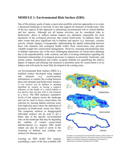
MODULE 1: Environmental Risk Surface (ERS)One of <strong>the</strong> primary goals of many conservation portfolio selection approaches is to createa functional landscape or network of sites that support all elements of biodiversity. Oneof <strong>the</strong> key aspects of this approach is minimizing environmental risk to critical habitatsand key species. Although not all human activities can be considered risks tobiodiversity, direct or indirect human impacts are ultimately responsible for mostalterations of <strong>the</strong> ecological processes that sustain biodiversity. In addition, <strong>the</strong>re areo<strong>the</strong>r events that pose significant risk to habitats and species (e.g. hurricane, volcanicactivity, climate change). Consequently, understanding <strong>the</strong> spatial relationship between<strong>the</strong>se risk elements and ecological health within focal conservation sites providesvaluable insight into conservation management. However, assessing and predicting risksto habitats represents one of <strong>the</strong> most challenging dimensions of conservation planningdue to <strong>the</strong> unpredictability, wide variation, and lack of existing information regarding <strong>the</strong>functional relationships of ecological processes to impacts in terrestrial, freshwater, andmarine realms. Standardized and widely accepted methods for quantifying <strong>the</strong> relativedegree of impacts and utilizing risk measures to prioritize areas for conservation is in itsinfancy and will surely be more fully developed in <strong>the</strong> coming years.An Environmental Risk Surface (ERS) is amodeled surface developed using mappedrisk elements (e.g. socioeconomicinformation) to explore <strong>the</strong> overlap between<strong>the</strong>se risk elements and biodiversity features.A risk element can be defined as anythingidentified by experts as having a negativeinfluence on <strong>the</strong> health of a critical habitat orkey species. One can also refer to risk elementsas a threat. The ERS measures cumulativelevels of risk impacts across <strong>the</strong> landscapeand can be used to focus conservation siteselection by steering habitat selection awayfrom high-risk areas where <strong>the</strong> abatement ofpressures on biodiversity seems less likely.The composite surfaces or disaggregatedindividual surfaces can be used to get abetter idea of <strong>the</strong> specific environmentalrisks on <strong>the</strong> landscape that may be degrading<strong>the</strong> viability of certain conservationhabitats/species (i.e. targets). ERS modeloutput can also be used to assist in <strong>the</strong>screening of habitats and creating costsurfaces for Marxan runs.Creating an ERS model first requiresassembling a suite of <strong>the</strong> best available GISExamples of customized Environmental Risk Surfaces (ERS) models forJamaica’s terrestrial, freshwater, and marine realms. Red areas indicatehigher risk to habitats based on <strong>the</strong> aggregation of intensities ofunderlying risk elements (McPherson et al, 2008)


