

Download the Tutorial
Download the Tutorial
Download the Tutorial

You also want an ePaper? Increase the reach of your titles
YUMPU automatically turns print PDFs into web optimized ePapers that Google loves.
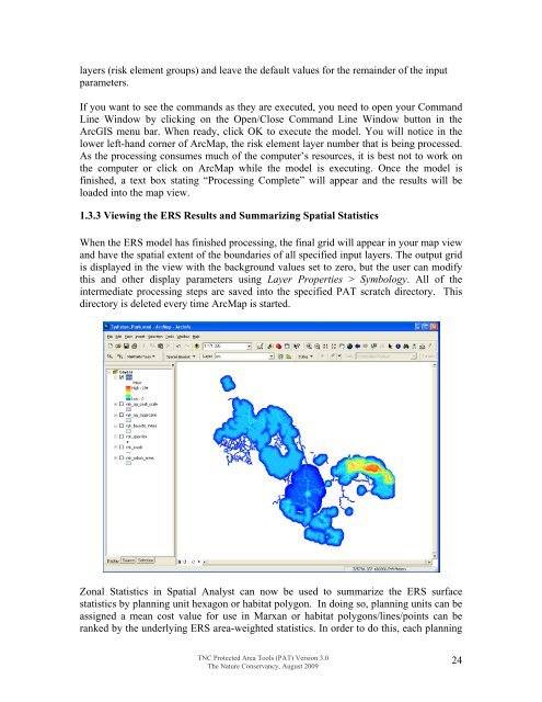
layers (risk element groups) and leave <strong>the</strong> default values for <strong>the</strong> remainder of <strong>the</strong> inputparameters.If you want to see <strong>the</strong> commands as <strong>the</strong>y are executed, you need to open your CommandLine Window by clicking on <strong>the</strong> Open/Close Command Line Window button in <strong>the</strong>ArcGIS menu bar. When ready, click OK to execute <strong>the</strong> model. You will notice in <strong>the</strong>lower left-hand corner of ArcMap, <strong>the</strong> risk element layer number that is being processed.As <strong>the</strong> processing consumes much of <strong>the</strong> computer’s resources, it is best not to work on<strong>the</strong> computer or click on ArcMap while <strong>the</strong> model is executing. Once <strong>the</strong> model isfinished, a text box stating “Processing Complete” will appear and <strong>the</strong> results will beloaded into <strong>the</strong> map view.1.3.3 Viewing <strong>the</strong> ERS Results and Summarizing Spatial StatisticsWhen <strong>the</strong> ERS model has finished processing, <strong>the</strong> final grid will appear in your map viewand have <strong>the</strong> spatial extent of <strong>the</strong> boundaries of all specified input layers. The output gridis displayed in <strong>the</strong> view with <strong>the</strong> background values set to zero, but <strong>the</strong> user can modifythis and o<strong>the</strong>r display parameters using Layer Properties > Symbology. All of <strong>the</strong>intermediate processing steps are saved into <strong>the</strong> specified PAT scratch directory. Thisdirectory is deleted every time ArcMap is started.Zonal Statistics in Spatial Analyst can now be used to summarize <strong>the</strong> ERS surfacestatistics by planning unit hexagon or habitat polygon. In doing so, planning units can beassigned a mean cost value for use in Marxan or habitat polygons/lines/points can beranked by <strong>the</strong> underlying ERS area-weighted statistics. In order to do this, each planningTNC Protected Area Tools (PAT) Version 3.0The Nature Conservancy, August 200924


