

Download the Tutorial
Download the Tutorial
Download the Tutorial

You also want an ePaper? Increase the reach of your titles
YUMPU automatically turns print PDFs into web optimized ePapers that Google loves.
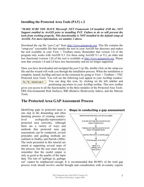
Installing <strong>the</strong> Protected Area Tools (PAT) v.2*MAKE SURE YOU HAVE Microsoft .NET Framework 2.0 installed AND <strong>the</strong> .NETSupport enabled in ArcGIS prior to installing PAT. Failure to do so will prevent <strong>the</strong>tools from working properly. This functionality is NOT installed in <strong>the</strong> default setup ofArcGIS. For more information, see number 2 above.<strong>Download</strong> <strong>the</strong> zip file “patv2.zip” from http://www.gispatools.org. This file contains <strong>the</strong>“setup.exe” executable file that installs <strong>the</strong> tool in your ArcGIS bin directory and makes<strong>the</strong> tool available in your View > Toolbars menu. Remember that version 3.0 of <strong>the</strong>program only works with ArcGIS 9.3. For those using ArcGIS 9.1 or 9.2, an older andless functional (version 1.0) of <strong>the</strong> tool is available at http://www.gispatools.org. Pleasenote that versions 1.0 and 2.0 have less functionality and are no longer supported.Once you have downloaded and unzipped <strong>the</strong> patv2.zip file, double click on <strong>the</strong> setup.exefile and <strong>the</strong> wizard will walk you through <strong>the</strong> installation process. When <strong>the</strong> installation iscomplete, launch ArcMap and turn on <strong>the</strong> extension by going to View > Toolbars > TNCProtected Area Tools. You will see <strong>the</strong> following icon appear in your ArcMap window:You can drag this icon, by clicking on <strong>the</strong> left sidebar andpositioning anywhere in your ArcMap toolbar. This new toolbargives you access to all <strong>the</strong> functionality in <strong>the</strong> three modules of <strong>the</strong> Protected Area Tools:ERS (Environmental Risk Surface), RBI (Relative Biodiversity Index), and <strong>the</strong> MarxanTools.The Protected Area GAP Assessment ProcessIdentifying gaps in protected areas isone step in <strong>the</strong> demanding and oftendaunting process of creating countrylevelecologically-representativeprotected area networks. Although<strong>the</strong>re are a variety of ways andmethods that protected area gapassessments can be conducted, severalprinciples and guiding methods areoutlined in Dudley and Parrish (2006).The tools presented in this tutorial areaimed at supporting several steps ofthis process, but <strong>the</strong> user must alwaysremember that <strong>the</strong> model output isonly as good as <strong>the</strong> quality of <strong>the</strong> inputdata. The rule of “garbage in, garbageout” cannot be emphasized enough. It is recommended that 80-90% of <strong>the</strong> total gapprocess work should involve careful thought and consideration with in-country expertsTNC Protected Area Tools (PAT) Version 3.0The Nature Conservancy, August 20097


