

Download the Tutorial
Download the Tutorial
Download the Tutorial

You also want an ePaper? Increase the reach of your titles
YUMPU automatically turns print PDFs into web optimized ePapers that Google loves.
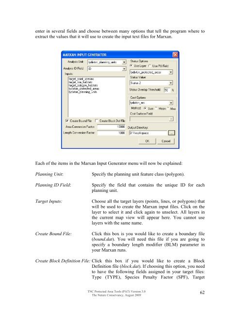
enter in several fields and choose between many options that tell <strong>the</strong> program where toextract <strong>the</strong> values that it will use to create <strong>the</strong> input text files for Marxan.Each of <strong>the</strong> items in <strong>the</strong> Marxan Input Generator menu will now be explained:Planning Unit:Planning ID Field:Target Inputs:Create Bound File:Specify <strong>the</strong> planning unit feature class (polygon).Specify <strong>the</strong> field that contains <strong>the</strong> unique ID for eachplanning unit.Choose all <strong>the</strong> target layers (points, lines, or polygons) thatwill be used to create <strong>the</strong> Marxan input files. Click on <strong>the</strong>layer to select it and click again to unselect. All layers in<strong>the</strong> current map view will appear here. You cannot uselayers with <strong>the</strong> same name.Click this box is you would like to create a boundary file(bound.dat). You will need this file if you are going tospecify a boundary length modifier (BLM) parameter inyour Marxan runs.Create Block Definition File: Click this box if you would like to create a BlockDefinition file (block.dat). If choosing this option, you needto have <strong>the</strong> following fields assigned in your target files:Type (TYPE), Species Penalty Factor (SPF), TargetTNC Protected Area Tools (PAT) Version 3.0The Nature Conservancy, August 200962


