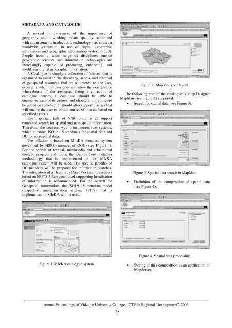
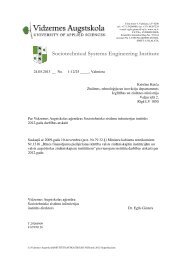
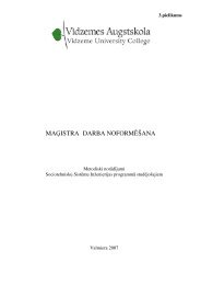
METADATA AND CATALOGUEA revival <strong>in</strong> awareness of the importance ofgeography and how th<strong>in</strong>gs relate spatially, comb<strong>in</strong>edwith advancements <strong>in</strong> electronic technology, has caused aworldwide expansion <strong>in</strong> use of digital geographic<strong>in</strong><strong>format</strong>ion and geographic <strong>in</strong><strong>format</strong>ion systems (GIS).People from a wide range of discipl<strong>in</strong>es outsidegeographic sciences and <strong>in</strong><strong>format</strong>ion technologies are<strong>in</strong>creas<strong>in</strong>gly capable of produc<strong>in</strong>g, enhanc<strong>in</strong>g, andmodify<strong>in</strong>g digital geographic <strong>in</strong><strong>format</strong>ion.A Catalogue is simply a collection of 'entries' that isorganized to assist <strong>in</strong> the discovery, access, and retrievalof geospatial resources that are of <strong>in</strong>terest to the user,especially when the user does not know the existence orwhereabouts of the resource. Be<strong>in</strong>g a collection ofcatalogue entries, a catalogue should be able toenumerate each of its entries, and should allow entries tobe added or removed. It should also support queries thatwill enable the user to obta<strong>in</strong> entries of <strong>in</strong>terest based onspecified criteria.The important task of NNR portal is to supportcomb<strong>in</strong>ed search for spatial and non-spatial <strong>in</strong><strong>format</strong>ion.Therefore, the decision was to implement two systems,which comb<strong>in</strong>e ISO19115 standards for spatial data andDC for non-spatial data.The solution is based on MIcKA metadata systemdeveloped by HSRS (member of OGC) (see Figure 1).For the search of textual, multimedia and educationalcontent, projects and tools, the Dubl<strong>in</strong> Core metadatamethodology that is implemented <strong>in</strong> the MIcKAcatalogue system will be used. The specific profiles ofDC metadata will be prepared for <strong>in</strong><strong>format</strong>ion searches.The <strong>in</strong>tegration of a Thesaurus (AgroVoc) and Gazetteersbased on NUTS 5 European level support<strong>in</strong>g localisationof <strong>in</strong><strong>format</strong>ion is recommended. For the search forGeospatial <strong>in</strong><strong>format</strong>ion, the ISO19115 metadata model(respective implementation scheme 19139) that isimplemented <strong>in</strong> MIcKA will be used.Figure 2. Map Designer layout.The follow<strong>in</strong>g part of the catalogue is Map DesignerMapMan (see Figure 2) supported:• Search for spatial data (see Figure 3);Figure 3. Spatial data search <strong>in</strong> MapMan.• Def<strong>in</strong>ition of the composition of spatial data(see Figure 4);Figure 4. Spatial data process<strong>in</strong>g.Figure 1. MicKA catalogue system.• Stor<strong>in</strong>g of this composition as an application ofMapServer.Annual <strong>Proceed<strong>in</strong>gs</strong> of Vidzeme University College “ICTE <strong>in</strong> Regional Development”, 200638
SPATIAL INFORMATIONFor the visualisation of spatial data, the open sourcesoftware MapServer, developed by University ofM<strong>in</strong>nesota (USA) with<strong>in</strong> the frame of a NASA grant, isused. The MapServer output is a raster map <strong>in</strong> GIF, PNG,JPG (for Internet browsers of personal or pocketcomputers) or WBMP <strong>format</strong>s (for mobile phonessupport<strong>in</strong>g WAP), and optionally PDF or GML vector<strong>format</strong>. Our applications use the wide range ofpossibilities provided by MapServer. Two clients areimplemented. For professional work, it will be JavaScript clients. For the work of non-specialists and for<strong>in</strong>tegration with e-learn<strong>in</strong>g application, a DHTML clientwill be used.E-LEARNING PLATFORMNNR aims to promote the concept of SD through theInternet by provid<strong>in</strong>g <strong>in</strong>novative tools and web services.The concept of SD will be demonstrated throughexample use case scenarios <strong>in</strong> test regions associatedwith the NNR project as well as at the European scale.The scenarios are embedded <strong>in</strong> an e-learn<strong>in</strong>genvironment that guides the user through structured usecase modules.The focus of this part of the NNR project isvisualisation and use of geographical data s<strong>in</strong>ce theenvironmental component of SD has a stronggeographical relationship. Geographical <strong>in</strong><strong>format</strong>ion ispresented <strong>in</strong> 2D by the open source M<strong>in</strong>nesota MapServer that will be implemented <strong>in</strong>to the e-learn<strong>in</strong>gplatform ILIAS. In addition to that, this data will also beaccessible by a 3D viewer that provides additional<strong>in</strong><strong>format</strong>ion about the terra<strong>in</strong>.These courses will be established for each test regionthereby present<strong>in</strong>g the specific challenges for SD. For alltest regions, a variety of geographical data is availableand already implemented on the web server. Economicdevelopment, e.g. <strong>in</strong> terms of <strong>in</strong>dustrial growth or just the<strong>in</strong>crease of urban areas, can have negative effects on theenvironment and society if this process is not managed.Planners require appropriate tools for the susta<strong>in</strong>ablemanagement of geographic areas that provide<strong>in</strong><strong>format</strong>ion about the potential effects on theenvironment <strong>in</strong> advance. For this reason a NNR-specificSusta<strong>in</strong>ability Impact Assessment, based on thepr<strong>in</strong>ciples of the Environmental Impact Assessment, willbe provided as a learn<strong>in</strong>g module with the aim tosensitize the user to the potential impacts of physicaldevelopment projects with regard to their environmental,social and economic parameters. The module will conta<strong>in</strong><strong>in</strong>teractive matrices that enable the user to rate the impactfor each parameter. In this context, the geodata withenvironmental, social, and economic relation provide the<strong>in</strong><strong>format</strong>ion required for such an assessment. In additionto the application <strong>in</strong> the web portal, mobile devices willbe applied <strong>in</strong> an outdoor environment <strong>in</strong> order to verifyand/or add actual data to the database of the system.3D-PRESENTATION OF SPATIALINFORMATIONAccord<strong>in</strong>g to the requirements of the project a realtimelandscape visualisation that allows the <strong>in</strong>tegration ofadditional multimedia <strong>in</strong><strong>format</strong>ion was realised. Nolicense cost, as well as the technological possibilities andthe performance were the ma<strong>in</strong> reasons to select theShockwave3D solution for the real-time visualisationmodule. The 3D-presentation of spatial data is animportant and impressive part of the <strong>in</strong><strong>format</strong>ionpresentation <strong>in</strong> the e-learn<strong>in</strong>g applications. The 3Dpresentationconsists of a 3D-viewer, which is very easyto handle, and which shows the three-dimensional spatialdata models to the user. This 3D-viewer is developedus<strong>in</strong>g Macromedia Director 8.5.Figure 5. Shockwave3D solution for spatial datapresentation.The 3D-models are built up from exist<strong>in</strong>g geo-datasources us<strong>in</strong>g standardised web-services for the geo-dataexchange. Figure 5 shows a prototype of the 3D-viewer,which conta<strong>in</strong>s navigation elements (pan / zoom / rotate)as well as an overview map and additional <strong>in</strong><strong>format</strong>ionbuttons (Almer et al., 2004).INTERACTIVE MULTIMEDIA EVENTSOne of the NNR project goals is to build a simple andflexible portal component which: provides organiz<strong>in</strong>gand conduct<strong>in</strong>g of multimedia events where participantsare allocated remotely; uses Internet as a tool via userfriendly NNR portal <strong>in</strong>terface; uses <strong>in</strong>expensive andwidespread hardware and software components.A multimedia event allows <strong>in</strong>dividuals or groups tomeet face-to-face <strong>in</strong> real time to <strong>in</strong>teract andAnnual <strong>Proceed<strong>in</strong>gs</strong> of Vidzeme University College “ICTE <strong>in</strong> Regional Development”, 200639
- Page 1 and 2: ISBN 9984-633-03-9Annual Proceeding
- Page 3 and 4: “Development of Creative Human -
- Page 5 and 6: TABLE OF CONTENTSINTELLIGENT SYSTEM
- Page 7 and 8: INTELLIGENT SYSTEM FOR LEARNERS’
- Page 9 and 10: LEARNER 1GROUP OF HUMAN AGENTSLEARN
- Page 11 and 12: QuantityQuantityFigure 6. Distribut
- Page 13 and 14: LEARNERStructure of theconcept mapL
- Page 15 and 16: WEB-BASED INTELLIGENT TUTORING SYST
- Page 17 and 18: materials to be presented and which
- Page 19 and 20: INFORMATION TECHNOLOGIES AND E-LEAR
- Page 21 and 22: correspondence with the course aim
- Page 23 and 24: projects and through IT. Hence, it
- Page 25 and 26: APPLICATION OF MODELING METHODS IN
- Page 27 and 28: can support configuration managemen
- Page 29 and 30: The EKD is one of the Enterprise mo
- Page 31 and 32: CHANGES TO TRAINING AND PERSPECTIVE
- Page 33 and 34: or an end, yet none of these attitu
- Page 35 and 36: make decisions. It cannot be volunt
- Page 37 and 38: logs), data and video conferencing
- Page 39 and 40: Ability to follow user’s multi-ta
- Page 41 and 42: CONCLUSIONSEDUSA method gives us a
- Page 43: in successful SD. Given this situat
- Page 47 and 48: MOBILE TECHNOLOGIES USE IN SERVICES
- Page 49 and 50: learning environment (Learning Mana
- Page 51 and 52: ago only some curricula on Logistic
- Page 53 and 54: The Web-based version can be access
- Page 55 and 56: Web-portal, which incorporates diff
- Page 57 and 58: DO INTELLIGENT OBJECTS AUTOMATICALL
- Page 59 and 60: Table 1. Examples for introducing R
- Page 61 and 62: workable influencing of the process
- Page 63 and 64: are handed over to the objects and
- Page 65 and 66: • Basic processes, such as wareho
- Page 67 and 68: THE ECR E-COACH: A VIRTUAL COACHING
- Page 69 and 70: participating in the workshops and
- Page 71 and 72: • Assessment modules enable indiv
- Page 73 and 74: with pictures and illustrated graph
- Page 75 and 76: ECR Question Banknumber category su
- Page 77 and 78: educational programme that follows
- Page 79 and 80: DEVELOPMENT OF WEB BASED GRAVITY MO
- Page 81 and 82: These results of a model require a
- Page 83 and 84: CONCLUSIONSThe main goal of work ha
- Page 85 and 86: dimension and included within any o
- Page 87 and 88: • Resources sharing by providing
- Page 89 and 90: Pursuant to the guidelines of elect
- Page 91 and 92: tariffs of regulated services have
- Page 93 and 94: INFORMATION TECHNOLOGY FOR MOTIVATI
- Page 95 and 96:
difficult to predict when and for w
- Page 97 and 98:
Listeners' workon the WebListenersS
- Page 99 and 100:
PERSPECTIVES OF WEB PAGE AND E-MAIL
- Page 101 and 102:
INCREASE IN THE NUMBER OF INTERNETU
- Page 103 and 104:
tourism accommodations (home pages
- Page 105 and 106:
interactive relationships with clie
- Page 107 and 108:
• The data obtained by the resear
- Page 109 and 110:
Central Statistical Bureau of Latvi
- Page 111 and 112:
departures for 1995 are taken from
- Page 113 and 114:
120100maximumworldminimum806040200-
- Page 115 and 116:
140120maximumworldminimum1008060402
- Page 117 and 118:
would be a promising extension. Cur
- Page 119 and 120:
AN OVERVIEW OF THE AGENT − BASED
- Page 121 and 122:
Suitability for social system simul
- Page 123 and 124:
6. MASONDescription:MASON is a fast
- Page 125 and 126:
Suitability for social system simul
- Page 127 and 128:
could be bad particularly when over
- Page 129 and 130:
(for 10 repeat &| CCar[]->runfor);P
- Page 131 and 132:
• Streaming audio• Collaboratio
- Page 133 and 134:
NECESSITY OF NEW LAYERED APPROACH T
- Page 135 and 136:
Up to now, there has only been limi
- Page 137 and 138:
aaaaa6= −aa2,1 = − a0,3226= −
- Page 139 and 140:
∂ u∂x∂ u∂y2 2+ b = 02 2wher
- Page 141 and 142:
a6,3= −2030a4,5−130a4,3- - - -
- Page 143 and 144:
0,10,20,30,4( )Mag x y y Ge wx2, =
- Page 145 and 146:
Example 1. To understand better the
- Page 147 and 148:
Therefore, further the following co
- Page 149 and 150:
SOLUTION OF THE THREE-DIMENSIONALEQ
- Page 151 and 152:
Mag1, m , m , m1 2 3= mm1 m2m32 2 2
- Page 153 and 154:
MagMag0, m , m , m1 2 31, m , m , m
- Page 155:
CONCLUSIONSThe basic content of thi