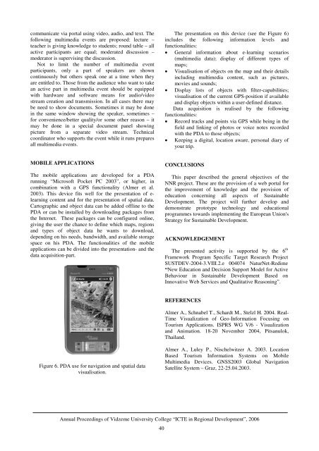
communicate via portal us<strong>in</strong>g video, audio, and text. Thefollow<strong>in</strong>g multimedia events are proposed: lecture –teacher is giv<strong>in</strong>g knowledge to students; round table – allactive participants are equal; moderated discussion –moderator is supervis<strong>in</strong>g the discussion.Not to limit the number of multimedia eventparticipants, only a part of speakers are showncont<strong>in</strong>uously but others speak one at a time when theyare entitled to. Those from the audience who want to takean active part <strong>in</strong> multimedia event should be equippedwith hardware and software means for audio/videostream creation and transmission. In all cases there maybe need to show documents. Sometimes it may be done<strong>in</strong> the same w<strong>in</strong>dow show<strong>in</strong>g the speaker, sometimes –for convenience/better quality/or some other reason – itmay be done <strong>in</strong> a special document panel show<strong>in</strong>gpicture from a separate video stream. Technicalcoord<strong>in</strong>ator who supports the event while it runs preparesall multimedia events.The presentation on this device (see the Figure 6)<strong>in</strong>cludes the follow<strong>in</strong>g <strong>in</strong><strong>format</strong>ion levels andfunctionalities:• General <strong>in</strong><strong>format</strong>ion about e-learn<strong>in</strong>g scenarios(multimedia data); display of different types ofmaps;• Visualisation of objects on the map and their details<strong>in</strong>clud<strong>in</strong>g multimedia content, such as pictures,movies and sounds;• Display lists of objects with filter-capabilities;visualisation of the current GPS-position if availableand display objects with<strong>in</strong> a user-def<strong>in</strong>ed distance.Data acquisition is realised by the follow<strong>in</strong>gfunctionalities:• Record tracks and po<strong>in</strong>ts via GPS while be<strong>in</strong>g <strong>in</strong> thefield and l<strong>in</strong>k<strong>in</strong>g of photos or voice notes recordedwith the PDA to those objects;• Keep<strong>in</strong>g a digital, location aware, personal diary ofyour trip.MOBILE APPLICATIONSThe mobile applications are developed for a PDArunn<strong>in</strong>g “Microsoft Pocket PC 2003”, or higher, <strong>in</strong>comb<strong>in</strong>ation with a GPS functionality (Almer et al.2003). This device fits well for the presentation of e-learn<strong>in</strong>g content and for the presentation of spatial data.Cartographic and object data can be added offl<strong>in</strong>e to thePDA or can be <strong>in</strong>stalled by download<strong>in</strong>g packages fromthe Internet. These packages can be configured onl<strong>in</strong>e,giv<strong>in</strong>g the user the chance to def<strong>in</strong>e which maps, regionsand types of object data he wants to download,depend<strong>in</strong>g on his needs, bandwidth, and available storagespace on his PDA. The functionalities of the mobileapplications can be divided <strong>in</strong>to the presentation- and thedata acquisition-part.CONCLUSIONSThis paper described the general objectives of theNNR project. These are the provision of a web portal forthe improvement of knowledge and the provision ofeducation concern<strong>in</strong>g all aspects of Susta<strong>in</strong>ableDevelopment. The project will further develop anddemonstrate prototype technology and educationalprogrammes towards implement<strong>in</strong>g the European Union'sStrategy for Susta<strong>in</strong>able Development.ACKNOWLEDGEMENTThe presented activity is supported by the 6 thFramework Program Specific Target Research ProjectSUSTDEV-2004-3.VIII.2.e 004074 NaturNet-Redime“New Education and Decision Support Model for ActiveBehaviour <strong>in</strong> Susta<strong>in</strong>able Development Based onInnovative Web Services and Qualitative Reason<strong>in</strong>g”.REFERENCESAlmer A., Schnabel T., Schardt M., Stelzl H. 2004. Real-Time Visualization of Geo-In<strong>format</strong>ion Focus<strong>in</strong>g onTourism Applications. ISPRS WG V/6 - Visualizationand Animation. 18-20 November 2004, Pitsanulok,Thailand.Figure 6. PDA use for navigation and spatial datavisualisation.Almer A., Luley P., Nischelwitzer A. 2003. LocationBased Tourism In<strong>format</strong>ion <strong>Systems</strong> on MobileMultimedia Devices. GNSS2003 Global NavigationSatellite System – Graz, 22-25.04.2003.Annual <strong>Proceed<strong>in</strong>gs</strong> of Vidzeme University College “ICTE <strong>in</strong> Regional Development”, 200640
MOBILE TECHNOLOGIES USE IN SERVICES DEVELOPMENT AND TRAINING IN LOGISTICSINFORMATION SYSTEMSEberhard Bluemel 1 , Egils G<strong>in</strong>ters 2 , Atis Kapenieks 3 , Leonid Novitsky 4 , Ilmars Slaid<strong>in</strong>s 31 Fraunhofer Institute for Factory Operation and Automation, Magdeburg, GermanyE-mail: eberhard.bluemel@iff.fraunhofer.de2 Vidzeme University College, Valmiera, LatviaE-mail: egils.g<strong>in</strong>ters@va.lv3 Riga Technical University, Distance Education Centre, Riga, LatviaE-mail: desc@rsf.rtu.lv4 Riga Technical University, Division of Applied <strong>Systems</strong> Software, Riga, LatviaE-mail: idc@balva.lvKEYWORDSLogistics In<strong>format</strong>ion <strong>Systems</strong>, e-learn<strong>in</strong>g, m-consultation, m-Work, mobile technologies.ABSTRACTThe rapid development of the modern knowledgebasedeconomy determ<strong>in</strong>es the use of advanced<strong>in</strong><strong>format</strong>ion process<strong>in</strong>g and control systems, which havegreat impact on quality of provided logistics andtransportation services. Quick changes of In<strong>format</strong>ion &Communication Technologies and Electronics (ICTE)ask for reduc<strong>in</strong>g the tra<strong>in</strong><strong>in</strong>g time and regular upgrade ofknowledge and skills.The LOGIS projects set started <strong>in</strong> 2000 was aimed tosolv<strong>in</strong>g the problems mentioned above provid<strong>in</strong>g e-learn<strong>in</strong>g and m-consultation possibilities us<strong>in</strong>g Webbasedsolutions and cellular GSM/UMTS networks.The eLogmar-M project started <strong>in</strong> 2004 was parallel<strong>in</strong>troduction of ga<strong>in</strong>ed experience <strong>in</strong> servicesdevelopment based on mobile technologies use, but newEU funded projectVPD1/ERAF/CFLA/05/APK/2.5.1/000078/038PUMPURS is aimed to generaliz<strong>in</strong>g the knowledge ofdifferent areas obta<strong>in</strong>ed before and elaboration therecommendations for mobile technologies use <strong>in</strong> learn<strong>in</strong>gand tra<strong>in</strong><strong>in</strong>g development.achievements of ICTE <strong>in</strong> transportation systems. Tak<strong>in</strong>gthese factors <strong>in</strong>to, it was decided to launch the first stepLeonardo da V<strong>in</strong>ci project LOGIS LV-PP-138.003(2000-2002) “Long-distance tutorial network <strong>in</strong>“Logistics In<strong>format</strong>ion <strong>Systems</strong>” based on WEBtechnologies” (G<strong>in</strong>ters and Krecere 2003) and work outlectures, and tra<strong>in</strong><strong>in</strong>g course on Logistics In<strong>format</strong>ion<strong>Systems</strong> pr<strong>in</strong>ted and e-learn<strong>in</strong>g form (seehttp://www.teachsys.com or http://www.logis-edu.com).However, technology pressure is very high, and it asksfor regular retra<strong>in</strong><strong>in</strong>g of specialists.The 2001 Annual Report of the European Foundationfor the Improvement of Liv<strong>in</strong>g and Work<strong>in</strong>g Conditions<strong>in</strong>dicated that more than 2 <strong>in</strong> 5 workers said that they donot have enough time to do their job. In reality, thismeans that they also do not have enough time to upgradetheir knowledge <strong>in</strong> the traditional way – <strong>in</strong> the classroom.Typical e-learn<strong>in</strong>g forms solve this problem onlypartially because is not a big difference to read the bookor to study this material <strong>in</strong> electronic form with orwithout Internet access. Therefore, to reduce tra<strong>in</strong><strong>in</strong>gtime the Vocational Education Tra<strong>in</strong><strong>in</strong>g (VET) methodsmust be modified. It was the ma<strong>in</strong> task of the next stepLeonardo da V<strong>in</strong>ci project LOGIS MOBILELV/04/B/F/PP-172.001 “Competence Framework forMobile On-site Accelerated Vocational Tra<strong>in</strong><strong>in</strong>g <strong>in</strong>Logistics In<strong>format</strong>ion <strong>Systems</strong>” aimed to <strong>in</strong>troduction ofm-tra<strong>in</strong><strong>in</strong>g and m-consultation forms based on mobilecommunications.INTRODUCTIONThe experience acquired dur<strong>in</strong>g previous projects:INCO Copernicus Programme AMCAI 0312 (1994-1997) and DAMAC-HP PL976012 (1998-2000)approved lack of <strong>in</strong>terdiscipl<strong>in</strong>ary knowledge of logisticsmanagers and data process<strong>in</strong>g systems adm<strong>in</strong>istrators.Only some logistics managers demonstrated enoughICTE skills. Otherwise, data process<strong>in</strong>g networkadm<strong>in</strong>istrators often were <strong>in</strong>competent <strong>in</strong> logisticsprocesses. This affects the <strong>in</strong>troduction of modernFIRST STAGE IN LOGIS DEVELOPMENT – E-LEARNINGWith<strong>in</strong> the framework of the Leonardo da V<strong>in</strong>ciprogramme project LOGIS LV-PP-138.003 (2000-2002)(G<strong>in</strong>ters and Krecere 2003) that <strong>in</strong>volves experiences ofboth universities and transit companies the task how toprepare specialists for solv<strong>in</strong>g problems <strong>in</strong> analysis,design, and exploitation of logistics <strong>in</strong><strong>format</strong>ionprocess<strong>in</strong>g systems was explored.Annual <strong>Proceed<strong>in</strong>gs</strong> of Vidzeme University College “ICTE <strong>in</strong> Regional Development”, 200641
- Page 1 and 2: ISBN 9984-633-03-9Annual Proceeding
- Page 3 and 4: “Development of Creative Human -
- Page 5 and 6: TABLE OF CONTENTSINTELLIGENT SYSTEM
- Page 7 and 8: INTELLIGENT SYSTEM FOR LEARNERS’
- Page 9 and 10: LEARNER 1GROUP OF HUMAN AGENTSLEARN
- Page 11 and 12: QuantityQuantityFigure 6. Distribut
- Page 13 and 14: LEARNERStructure of theconcept mapL
- Page 15 and 16: WEB-BASED INTELLIGENT TUTORING SYST
- Page 17 and 18: materials to be presented and which
- Page 19 and 20: INFORMATION TECHNOLOGIES AND E-LEAR
- Page 21 and 22: correspondence with the course aim
- Page 23 and 24: projects and through IT. Hence, it
- Page 25 and 26: APPLICATION OF MODELING METHODS IN
- Page 27 and 28: can support configuration managemen
- Page 29 and 30: The EKD is one of the Enterprise mo
- Page 31 and 32: CHANGES TO TRAINING AND PERSPECTIVE
- Page 33 and 34: or an end, yet none of these attitu
- Page 35 and 36: make decisions. It cannot be volunt
- Page 37 and 38: logs), data and video conferencing
- Page 39 and 40: Ability to follow user’s multi-ta
- Page 41 and 42: CONCLUSIONSEDUSA method gives us a
- Page 43 and 44: in successful SD. Given this situat
- Page 45: SPATIAL INFORMATIONFor the visualis
- Page 49 and 50: learning environment (Learning Mana
- Page 51 and 52: ago only some curricula on Logistic
- Page 53 and 54: The Web-based version can be access
- Page 55 and 56: Web-portal, which incorporates diff
- Page 57 and 58: DO INTELLIGENT OBJECTS AUTOMATICALL
- Page 59 and 60: Table 1. Examples for introducing R
- Page 61 and 62: workable influencing of the process
- Page 63 and 64: are handed over to the objects and
- Page 65 and 66: • Basic processes, such as wareho
- Page 67 and 68: THE ECR E-COACH: A VIRTUAL COACHING
- Page 69 and 70: participating in the workshops and
- Page 71 and 72: • Assessment modules enable indiv
- Page 73 and 74: with pictures and illustrated graph
- Page 75 and 76: ECR Question Banknumber category su
- Page 77 and 78: educational programme that follows
- Page 79 and 80: DEVELOPMENT OF WEB BASED GRAVITY MO
- Page 81 and 82: These results of a model require a
- Page 83 and 84: CONCLUSIONSThe main goal of work ha
- Page 85 and 86: dimension and included within any o
- Page 87 and 88: • Resources sharing by providing
- Page 89 and 90: Pursuant to the guidelines of elect
- Page 91 and 92: tariffs of regulated services have
- Page 93 and 94: INFORMATION TECHNOLOGY FOR MOTIVATI
- Page 95 and 96: difficult to predict when and for w
- Page 97 and 98:
Listeners' workon the WebListenersS
- Page 99 and 100:
PERSPECTIVES OF WEB PAGE AND E-MAIL
- Page 101 and 102:
INCREASE IN THE NUMBER OF INTERNETU
- Page 103 and 104:
tourism accommodations (home pages
- Page 105 and 106:
interactive relationships with clie
- Page 107 and 108:
• The data obtained by the resear
- Page 109 and 110:
Central Statistical Bureau of Latvi
- Page 111 and 112:
departures for 1995 are taken from
- Page 113 and 114:
120100maximumworldminimum806040200-
- Page 115 and 116:
140120maximumworldminimum1008060402
- Page 117 and 118:
would be a promising extension. Cur
- Page 119 and 120:
AN OVERVIEW OF THE AGENT − BASED
- Page 121 and 122:
Suitability for social system simul
- Page 123 and 124:
6. MASONDescription:MASON is a fast
- Page 125 and 126:
Suitability for social system simul
- Page 127 and 128:
could be bad particularly when over
- Page 129 and 130:
(for 10 repeat &| CCar[]->runfor);P
- Page 131 and 132:
• Streaming audio• Collaboratio
- Page 133 and 134:
NECESSITY OF NEW LAYERED APPROACH T
- Page 135 and 136:
Up to now, there has only been limi
- Page 137 and 138:
aaaaa6= −aa2,1 = − a0,3226= −
- Page 139 and 140:
∂ u∂x∂ u∂y2 2+ b = 02 2wher
- Page 141 and 142:
a6,3= −2030a4,5−130a4,3- - - -
- Page 143 and 144:
0,10,20,30,4( )Mag x y y Ge wx2, =
- Page 145 and 146:
Example 1. To understand better the
- Page 147 and 148:
Therefore, further the following co
- Page 149 and 150:
SOLUTION OF THE THREE-DIMENSIONALEQ
- Page 151 and 152:
Mag1, m , m , m1 2 3= mm1 m2m32 2 2
- Page 153 and 154:
MagMag0, m , m , m1 2 31, m , m , m
- Page 155:
CONCLUSIONSThe basic content of thi