

Local Development Plan
2oBkyQa
2oBkyQa

You also want an ePaper? Increase the reach of your titles
YUMPU automatically turns print PDFs into web optimized ePapers that Google loves.
4 | Spatial Context<br />
4 | Spatial Context<br />
Population<br />
Population<br />
4 The | Council Spatial area Context extends to an area of almost 200 square miles and<br />
The borders Council the area five adjoining extends to Council an area areas of almost of Belfast 200 City square Council, miles Armagh<br />
and<br />
Population<br />
borders City, Banbridge the five and adjoining Craigavon Council Borough areas Council, of Belfast Antrim City Council, and<br />
Armagh<br />
Newtownabbey The City, Council Banbridge area and Borough extends Craigavon Council, to an Borough area Ards of almost and Council, North 200 Antrim Down square and Borough miles and Council,<br />
Newtownabbey and borders Newry, the Mourne five Borough adjoining and Down Council, District Ards areas Council.<br />
and of Belfast North Down City Council, Borough Armagh<br />
Council,<br />
and City, Newry, Banbridge Mourne and Craigavon and Down Borough District Council. Council, Antrim and<br />
In 2015 the population of the Lisburn & Castlereagh City Council Area was<br />
Newtownabbey In estimated 2015 the at population 140,205<br />
Borough<br />
(Mid-2015 of<br />
Council, the Lisburn Population<br />
Ards &<br />
and Castlereagh<br />
North<br />
Estimates,<br />
Down City published<br />
Borough Council Area<br />
Council,<br />
31 st<br />
was<br />
and<br />
estimated<br />
Newry, Mourne and Down District Council.<br />
August 2016 at for 140,205 Northern (Mid-2015 Ireland). Population 68,728 (49.0%) Estimates, were published male and 31 71,477<br />
st<br />
In August (51.0%) 2015 2016 the were population for female. Northern This of the Ireland). was Lisburn made 68,728 up & Castlereagh of:<br />
(49.0%) were City male Council and Area 71,477 was<br />
estimated (51.0%) were at 140,205 female. (Mid-2015 This was made Population up of: Estimates, published 31 st<br />
August • 2016 28,053 for children Northern aged Ireland). 0-15 years; 68,728 (49.0%) were male and 71,477<br />
(51.0%) • 28,053 41,571 were female. children people This aged was 16-39 0-15 made years; up of:<br />
• 41,571 46,942 people aged 16-39 40-64 years; and<br />
• 28,053<br />
46,942 23,639<br />
children people aged 65 years<br />
aged<br />
40-64 and<br />
0-15 years;<br />
years; older and<br />
• 41,571<br />
23,639 people<br />
people aged<br />
65 years<br />
16-39 and<br />
years;<br />
older<br />
From NISRA-based<br />
• 46,942 people<br />
population<br />
aged 40-64<br />
projections<br />
years; and<br />
8 , it is estimated that the<br />
population From<br />
• NISRA-based<br />
23,639 of the people Council population<br />
65 area years projections is and expected older<br />
8 , to it grow is estimated from 140,205 that the in 2015<br />
population to 158,618 in of 2030, the Council which area is a projected is expected population to grow from increase 140,205 of 18,413 in 2015 or<br />
to a From growth 158,618 NISRA-based rate in 2030, of 13.1%. population which is a projected projections population 8 , it is estimated increase that of the<br />
18,413 or<br />
population a growth rate of the of 13.1%. Council area is expected to grow from 140,205 in 2015<br />
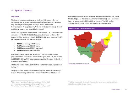
The Council area is made up of 7 District Electoral areas (DEAs) as shown<br />
The<br />
to<br />
in Map<br />
158,618 Council 1 9 .<br />
in area<br />
2030, is made<br />
which up<br />
is a of<br />
projected 7 District<br />
population Electoral areas<br />
increase (DEAs)<br />
of as<br />
18,413 shown<br />
or<br />
a<br />
in<br />
growth Map 1 9 rate .<br />
of 13.1%.<br />
The population is made up of approximately 85% within settlements (i.e.<br />
Lisburn<br />
The The<br />
Council population & Castlereagh<br />
area is<br />
is made<br />
made<br />
City up<br />
up<br />
and of<br />
of approximately the<br />
7 District<br />
Greater<br />
Electoral<br />
Urban 85% within<br />
areas<br />
Areas<br />
(DEAs)<br />
of settlements Lisburn<br />
as shown<br />
and<br />
(i.e.<br />
Lisburn<br />
in Map 1 & 9 .<br />
Castlereagh City and the Greater Urban Areas of Lisburn and<br />
The 8 2014 population Based Population is made Projections up of approximately (published 2585% May within 2016) settlements (i.e.<br />
Lisburn 8 www.nisra.gov.uk/demography/default.asp47.htm<br />
2014 Based<br />
& Castlereagh Population<br />
City Projections<br />
and the (published<br />
Greater Urban 25 May<br />
Areas 2016)<br />
9 of Lisburn and<br />
www.nisra.gov.uk/demography/default.asp47.htm<br />
A full list of Maps, Figures & Tables supplied in Appendix D<br />
9<br />
8 A full list of Maps, Figures & Tables is supplied in Appendix D<br />
2014 Based Population Projections (published 25 May 2016)<br />
www.nisra.gov.uk/demography/default.asp47.htm<br />
9 A full list of Maps, Figures & Tables is supplied in Appendix D<br />
Castlereagh, followed by the towns of Carryduff, Hillsborough and Moira,<br />
Castlereagh, the 13 villages followed and the by remaining the towns 33 of small Carryduff, settlements); Hillsborough and a and population<br />
Moira,<br />
the figure 13 of villages approximately and the remaining 15% outside 33 small settlements settlements); 10 , which and further<br />
a population<br />
Castlereagh, figure supports of approximately the followed economic by vitality 15% the outside towns and viability of settlements Carryduff, of the 10 Hillsborough settlements.<br />
, which further and Moira,<br />
the supports 13 villages the economic and the remaining vitality and 33 viability small settlements); of the settlements. and a population<br />
figure of approximately 15% outside settlements 10 , which further<br />
supports Map 1: District the economic Electoral vitality Areas and (DEAs) viability of the settlements.<br />
Killultagh<br />
Downshire West<br />
© Crown copyright and database right 2016 CS&LA156<br />
Lisburn<br />
South<br />
Lisburn<br />
North<br />
Downshire East<br />
Castlereagh<br />
East<br />
Castlereagh<br />
South<br />
10 NISRA Headcount & Household Estimates for Settlements, published March<br />
2015, 10 NISRA based Headcount on 2011 & Census Household Figures<br />
Estimates for Settlements, published March<br />
2015, based on 2011 Census Figures<br />
10 NISRA Headcount & Household Estimates for Settlements, published March<br />
2015, based on 2011 Census Figures<br />
Spatial Context 13