

mag

You also want an ePaper? Increase the reach of your titles
YUMPU automatically turns print PDFs into web optimized ePapers that Google loves.
Malaysia Water Research Journal<br />
penetrated the structure via hollow sections and trapped behind the installation<br />
as the water flows back out. Hollow sections on the structure must be designed<br />
less than 50% of surface area to ensure optimum sediment entrapment. The<br />
design was also able to distribute wave energy evenly during high tide, reducing<br />
overtopping and scouring impact.<br />
5 ON SITE MEASUREMENT<br />
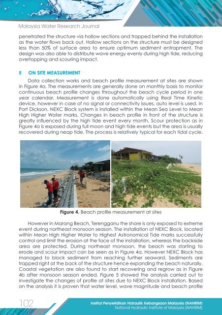
Data collection works and beach profile measurement at sites are shown<br />
in Figure 4a. The measurements are generally done on monthly basis to monitor<br />
continuous beach profile changes throughout the beach cycle period in one<br />
year calendar. Measurement is done automatically using Real Time Kinetic<br />
device, however in case of no signal or connectivity issues, auto level is used. In<br />
Port Dickson, NEXC Block system is installed within the Mean Sea Level to Mean<br />
High Higher Water marks. Changes in beach profile in front of the structure is<br />
greatly influenced by the high tide event every month. Scour protection as in<br />
Figure 4a is exposed during full moon and high tide events but the area is usually<br />
recovered during neap tide. The process is relatively typical for each tidal cycle.<br />
Figure 4. Beach profile measurement at sites<br />
However in Marang Beach, Terengganu the shore is only exposed to extreme<br />
event during northeast monsoon season. The installation of NEXC Block, located<br />
within Mean High Higher Water to Highest Astronomical Tide marks successfully<br />
control and limit the erosion at the face of the installation, whereas the backside<br />
area are protected. During northeast monsoon, the beach was starting to<br />
erode and scour impact can be seen as in Figure 4a. However NEXC Block has<br />
managed to block sediment from reaching further seaward. Sediments are<br />
trapped right at the back of the structure hence expanding the beach naturally.<br />
Coastal vegetation are also found to start recovering and regrow as in Figure<br />
4b after monsoon season ended. Figure 5 showed the analysis carried out to<br />
investigate the changes of profile at sites due to NEXC Block installation. Based<br />
on the analysis it is proven that water level, wave <strong>mag</strong>nitude and beach profile<br />
102<br />
Institut Penyelidikan Hidraulik Kebangsaan Malaysia (NAHRIM)<br />
National Hydraulic Institute of Malaysia (NAHRIM)