

mag

You also want an ePaper? Increase the reach of your titles
YUMPU automatically turns print PDFs into web optimized ePapers that Google loves.
Malaysia Water Research Journal<br />
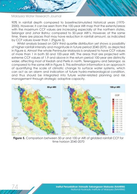
90% in rainfall depth compared to baseline/simulated historical years (1970-<br />
2000). However, it can be seen from the 100-year ARI map that the extents/areas<br />
with the maximum CCF values are increasing especially at the northern states,<br />
Selangor and Johor Bahru; compared to 50-year ARI’s. However, at the same<br />
time, there are places that may have reduction in rainfall amount, as indicated<br />
by CCF values lower than 1 (Figure 5).<br />
Whilst analysis based on GEV third quartile distribution yet shows a possibility<br />
of higher rainfall intensity and <strong>mag</strong>nitude in future period 2040-2070, as depicted<br />
in Figure 6. Almost the whole Peninsular Malaysia is analysed to have CCF values<br />
of more than 1 in both 50 and 100-year ARI. The areas that are projected with<br />
extreme CCF values of 1.9 and above in the return period 100-year are distinctly<br />
wider, affecting most of Kedah and Perlis in north, Terengganu and Selangor, as<br />
compared to the same ARI in Figure 5. This estimation information is an approach<br />
of quantifying the scale of climatic change to surface water systems, which<br />
can act as an alarm and indication of future hydro-meteorological condition,<br />
and thus should be integrated into future water-related planning and risk<br />
management through strategic adaptive capacity.<br />
Figure 5. Comparison between 50-yr and 100-yr ARI of gridded rainfall CCF for<br />
time horizon 2040-2070<br />
74<br />
Institut Penyelidikan Hidraulik Kebangsaan Malaysia (NAHRIM)<br />
National Hydraulic Institute of Malaysia (NAHRIM)