

mag

Create successful ePaper yourself
Turn your PDF publications into a flip-book with our unique Google optimized e-Paper software.
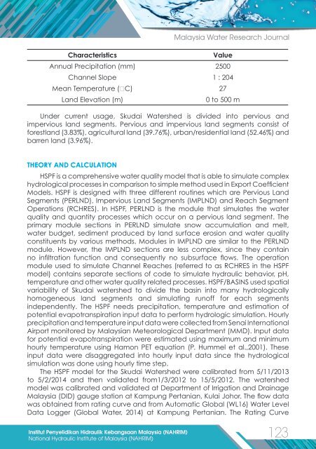
Characteristics<br />
Malaysia Water Research Journal<br />
Value<br />
Annual Precipitation (mm) 2500<br />
Channel Slope 1 : 204<br />
Mean Temperature (⁰C) 27<br />
Land Elevation (m)<br />
0 to 500 m<br />
Under current usage, Skudai Watershed is divided into pervious and<br />
impervious land segments. Pervious and impervious land segments consist of<br />
forestland (3.83%), agricultural land (39.76%), urban/residential land (52.46%) and<br />
barren land (3.96%).<br />
THEORY AND CALCULATION<br />
HSPF is a comprehensive water quality model that is able to simulate complex<br />
hydrological processes in comparison to simple method used in Export Coefficient<br />
Models. HSPF is designed with three different routines which are Pervious Land<br />
Segments (PERLND), Impervious Land Segments (IMPLND) and Reach Segment<br />
Operations (RCHRES). In HSPF, PERLND is the module that simulates the water<br />
quality and quantity processes which occur on a pervious land segment. The<br />
primary module sections in PERLND simulate snow accumulation and melt,<br />
water budget, sediment produced by land surface erosion and water quality<br />
constituents by various methods. Modules in IMPLND are similar to the PERLND<br />
module. However, the IMPLND sections are less complex, since they contain<br />
no infiltration function and consequently no subsurface flows. The operation<br />
module used to simulate Channel Reaches (referred to as RCHRES in the HSPF<br />
model) contains separate sections of code to simulate hydraulic behavior, pH,<br />
temperature and other water quality related processes. HSPF/BASINS used spatial<br />
variability of Skudai watershed to divide the basin into many hydrologically<br />
homogeneous land segments and simulating runoff for each segments<br />
independently. The HSPF needs precipitation, temperature and estimation of<br />
potential evapotranspiration input data to perform hydrologic simulation. Hourly<br />
precipitation and temperature input data were collected from Senai International<br />
Airport monitored by Malaysian Meteorological Department (MMD). Input data<br />
for potential evapotranspiration were estimated using maximum and minimum<br />
hourly temperature using Hamon PET equation (P. Hummel et al.,2001). These<br />
input data were disaggregated into hourly input data since the hydrological<br />
simulation was done using hourly time step.<br />
The HSPF model for the Skudai Watershed were calibrated from 5/11/2013<br />
to 5/2/2014 and then validated from1/3/2012 to 15/5/2012. The watershed<br />
model was calibrated and validated at Department of Irrigation and Drainage<br />
Malaysia (DID) gauge station at Kampung Pertanian, Kulai Johor. The flow data<br />
was obtained from rating curve and from Automatic Global (WL16) Water Level<br />
Data Logger (Global Water, 2014) at Kampung Pertanian. The Rating Curve<br />
Institut Penyelidikan Hidraulik Kebangsaan Malaysia (NAHRIM)<br />
123<br />
National Hydraulic Institute of Malaysia (NAHRIM)