

mag

You also want an ePaper? Increase the reach of your titles
YUMPU automatically turns print PDFs into web optimized ePapers that Google loves.
Malaysia Water Research Journal<br />
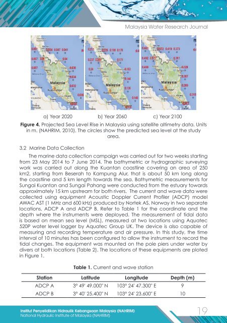
a) Year 2020 b) Year 2060 c) Year 2100<br />
Figure 4. Projected Sea Level Rise in Malaysia using satellite altimetry data. Units<br />
in m. (NAHRIM, 2010). The circles show the predicted sea level at the study<br />
area.<br />
3.2 Marine Data Collection<br />
The marine data collection campaign was carried out for two weeks starting<br />
from 23 May 2014 to 7 June 2014. The bathymetric or hydrographic surveying<br />
work was carried out along the Kuantan coastline covering an area of 250<br />
km2, starting from Beserah to Kampung Alur, that is about 50 km long along<br />
the coastline and 5 km length towards the sea. Bathymetric measurements for<br />
Sungai Kuantan and Sungai Pahang were conducted from the estuary towards<br />
approximately 15 km upstream for both rivers. The current and wave data were<br />
collected using equipment Acoustic Doppler Current Profiler (ADCP) model<br />
AWAC AST (1 MHz and 600 kHz) produced by Nortek AS, Norway in two separate<br />
locations, ADCP A and ADCP B. Refer to Table 1 for the coordinate and the<br />
depth where the instruments were deployed. The measurement of tidal data<br />
is based on mean sea level (MSL), measured at two locations using Aquatec<br />
520P water level logger by Aquatec Group UK. The device is also capable of<br />
measuring and recording temperature and air pressure. In this study, the time<br />
interval of 10 minutes has been configured to allow the instrument to record the<br />
tidal changes. The equipment was mounted on the pole piers under water by<br />
divers at both locations (Table 2). The locations of these equipments are ploted<br />
in Figure 1.<br />
Table 1. Current and wave station<br />
Station Latitude Longitude Depth (m)<br />
ADCP A 3° 49' 49.000" N 103° 24' 47.300" E 9<br />
ADCP B 3° 40' 25.400" N 103° 24' 23.600" E 10<br />
Institut Penyelidikan Hidraulik Kebangsaan Malaysia (NAHRIM)<br />
19<br />
National Hydraulic Institute of Malaysia (NAHRIM)