

mag

You also want an ePaper? Increase the reach of your titles
YUMPU automatically turns print PDFs into web optimized ePapers that Google loves.
Malaysia Water Research Journal<br />
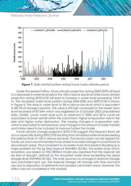
Figure 7. Daily rainfall pattern during future hydro-climate period<br />
Under the present inflow, future climate projection during 2040-2070 will lead<br />
to a decrease in water level below the 100 m above sea level while future climate<br />
projection during 2070-2100 will lead to increase in water level exceeding 104.9<br />
m. The simulated water level pattern during 2040-2050 and 2090-2100 is shown<br />
in Figure 8. The drop-in water level to 98 m above sea level which is equivalent<br />
to 80.7% of storage capacity. This value is still high compared to the lowest dam<br />
level recorded at 87.64m which was registered on 6 October 2005 (unpublished<br />
data, SAINS). Lower water level such as observed in 2005 and 2016 could be<br />
associated to lower rainfall within the catchment, higher evaporation rate in the<br />
lake and higher water abstraction. The varying changes in evaporation rate,<br />
which is associated to temperature, and changes in the amount of water transfer<br />
and intake need to be included to improve further the model.<br />
Future climate change projection 2070-2100 suggest that frequent flood will<br />
occur especially during 2092-2100 resulting from simulated water level exceeding<br />
the spillway level of 103 m above sea level. The excess water can be tapped for<br />
future use and is recommended to be stored in bunded storage to avoid flood to<br />
downstream areas. This is consistent to an earlier study that predicts flooding as a<br />
major problem for the Sg Terip reservoir (NAHRIM 2014b). The earlier study which<br />
simulation was based on HEC-RESSIM model also reported that the reservoir will<br />
be free of drought, defined as the simulated water level exceeding the dead<br />
storage level (NAHRIM 2014b). This work assumes no changes in reservoir storage<br />
and catchment land use. The reservoir storage will change with time and land<br />
use due to deposition of sediments from eroded catchment areas. However, this<br />
effect was not considered in the analysis.<br />
116<br />
Institut Penyelidikan Hidraulik Kebangsaan Malaysia (NAHRIM)<br />
National Hydraulic Institute of Malaysia (NAHRIM)