

mag

You also want an ePaper? Increase the reach of your titles
YUMPU automatically turns print PDFs into web optimized ePapers that Google loves.
Malaysia Water Research Journal<br />
study, after the initial calibration, LZSN was set at 0.16 m and held constant for all<br />
land uses. The upper zone nominal storage UZSN, a user specified parameter was<br />
set according to EPA BASINS Technical Note 6 (USEPA, 2000). Donigian et al. (1978)<br />
assumes UZSN as 0.06 of LZSN for steep slopes, limited vegetation, low depression<br />
storage; 0.08 of LZSN for moderate slopes, moderate vegetation, and moderate<br />
depression storage; 0.14 LZSN for heavy vegetal or forest cover, soils subject to<br />
cracking, high depression storage and very mild slopes and final value is set to<br />
be 0.55 inch. For Skudai Watershed, 0.08 of LZSN is used since it has moderate<br />
slope (0.5%) and moderate vegetation and depression storage. Since surface<br />
runoff and baseflow indicate direct contribution of water quality simulation, the<br />
fraction of groundwater inflow DEEPFR was set at 0.2 to ensure model stability.<br />
For the mean soil infiltration rate parameter, INFILT possible value was set to be<br />
0.24 in/hr and may decrease to produce more upper zone and interflow storage<br />
water. Excessive value of INFILT can lead to a greater overland flow and interflow<br />
in Skudai river. To have a better picture of these four parameters sensitivity, Table<br />
4 summarizes the detail analysis of these assessment.<br />
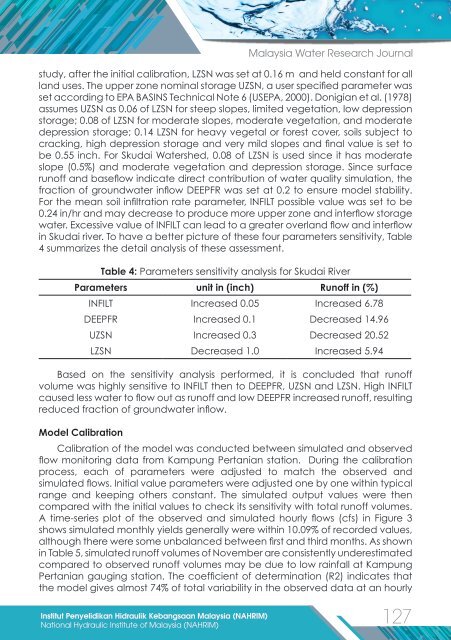
Table 4: Parameters sensitivity analysis for Skudai River<br />
Parameters unit in (inch) Runoff in (%)<br />
INFILT Increased 0.05 Increased 6.78<br />
DEEPFR Increased 0.1 Decreased 14.96<br />
UZSN Increased 0.3 Decreased 20.52<br />
LZSN Decreased 1.0 Increased 5.94<br />
Based on the sensitivity analysis performed, it is concluded that runoff<br />
volume was highly sensitive to INFILT then to DEEPFR, UZSN and LZSN. High INFILT<br />
caused less water to flow out as runoff and low DEEPFR increased runoff, resulting<br />
reduced fraction of groundwater inflow.<br />
Model Calibration<br />
Calibration of the model was conducted between simulated and observed<br />
flow monitoring data from Kampung Pertanian station. During the calibration<br />
process, each of parameters were adjusted to match the observed and<br />
simulated flows. Initial value parameters were adjusted one by one within typical<br />
range and keeping others constant. The simulated output values were then<br />
compared with the initial values to check its sensitivity with total runoff volumes.<br />
A time-series plot of the observed and simulated hourly flows (cfs) in Figure 3<br />
shows simulated monthly yields generally were within 10.09% of recorded values,<br />
although there were some unbalanced between first and third months. As shown<br />
in Table 5, simulated runoff volumes of November are consistently underestimated<br />
compared to observed runoff volumes may be due to low rainfall at Kampung<br />
Pertanian gauging station. The coefficient of determination (R2) indicates that<br />
the model gives almost 74% of total variability in the observed data at an hourly<br />
Institut Penyelidikan Hidraulik Kebangsaan Malaysia (NAHRIM)<br />
127<br />
National Hydraulic Institute of Malaysia (NAHRIM)