

mag

You also want an ePaper? Increase the reach of your titles
YUMPU automatically turns print PDFs into web optimized ePapers that Google loves.
Malaysia Water Research Journal<br />
2 STUDY AREA<br />
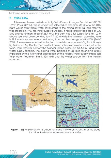
This research was carried out in Sg Terip Reservoir, Negeri Sembilan (102° 00’<br />
17’’ E, 2° 45’ 30’’ N). The reservoir was selected as research site due to the 2014<br />
state water crisis where water level drops to the critical level. Sg Terip reservoir<br />
was created in 1987 for water supply purposes. It has a total surface area of 2.43<br />
km2 and catchment area of 25.9 km2. The dam has a full supply level at 103 m<br />
above sea level corresponding to 47.7 MCM while the minimum operating level<br />
is 79.9 m above sea level contributing to an active storage of 44 MCM (SAINS<br />
2010). The reservoir received water from three tributaries namely Sg Anak Buaya,<br />
Sg Terip and Sg Gantor. Two water transfer schemes provide source of water<br />
to Sg. Terip reservoir namely the Kelinchi-Talang Reservoirs (98 MCM) and Triang<br />
water supply scheme. The existing water balance of Sg. Terip reservoir is largely<br />
impacted by the river water abstraction by the nearby water supply intake (Sg.<br />
Terip Water Treatment Plant, 136 Mld) and the water source from the transfer<br />
schemes.<br />
Figure 1. Sg Terip reservoir, its catchment and the water system. Inset the study<br />
location. Red arrow represents water transfer.<br />
108<br />
Institut Penyelidikan Hidraulik Kebangsaan Malaysia (NAHRIM)<br />
National Hydraulic Institute of Malaysia (NAHRIM)