

mag

Create successful ePaper yourself
Turn your PDF publications into a flip-book with our unique Google optimized e-Paper software.
Malaysia Water Research Journal<br />
• Columnar storage for parallel data processing<br />
• Heterogeneous structure query engine using GPU technology<br />
• Geo-spatial accelerated processing<br />
• Data visualization system of multi-billion record datasets<br />
For instance, the effectiveness of data processing accelerator was capable<br />
to perform quick analytics and visualization in only 14 seconds based on one<br />
scenario table for the whole 3888 grids, and about 3.5 minutes for all tables and<br />
scenarios. Comparatively, the identification of 127 million points for polygon of<br />
river basins and regions, and transformation into visualization in web server takes<br />
4.3 seconds, which is 77 times than other post-GIS systems.<br />
In general, there are currently eight (8) analytics features developed, which<br />
four (4) modules are from POC: drought, temperature, rainfall, storm center and<br />
streamflow, while three (3) new analytics features: climate change factor (CCF),<br />
water stress index (WSI) and WSI simulation are developed to assist engineers,<br />
development and utility planners, and main stakeholders in making timely<br />
decision and strategies in water-related risk management and development<br />
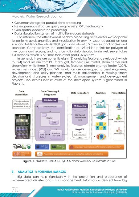
projects. The overall infrastructure of the developed system is generalized in<br />
Figure 1.<br />
Figure 1. NAHRIM’s BDA N-HyDAA data warehouse infrastructure.<br />
3 ANALYTICS 1: POTENTIAL IMPACTS<br />
Big data can help significantly in the prevention and preparation of<br />
water-related disaster and crisis management. Information derived from big<br />
70<br />
Institut Penyelidikan Hidraulik Kebangsaan Malaysia (NAHRIM)<br />
National Hydraulic Institute of Malaysia (NAHRIM)