St Mary Redcliffe Project 450 RIBA 2 Stage End Report

You also want an ePaper? Increase the reach of your titles
YUMPU automatically turns print PDFs into web optimized ePapers that Google loves.
ainage<br />
elopments. A<br />
the existing<br />
rmally required<br />
here are<br />
excavation<br />
to drain away<br />
this site due to<br />
ve.<br />
for storm<br />
ar to green<br />
h the green<br />
the south<br />
ounding trees.<br />
dditional weight<br />
upporting<br />
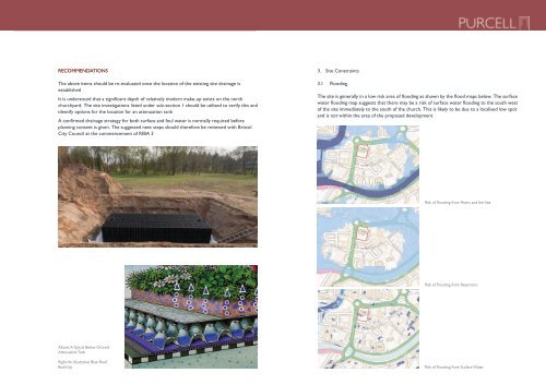
RECOMMENDATIONS<br />
3.3 Proposed Site Drainage<br />
The above Current items planning should requirements be re-evaluated dictate that SuDS (Sustainable once the Urban location Drainage of the existing site drainage is<br />
establishedSystems) 3.3 Proposed must be Site considered Drainage for surface water drainage on all new developments. A<br />
connection to the existing public sewer is a last resort. A betterment on the existing<br />
volume of stormwater run-off plus an allowance for climate change is normally required<br />
Current planning requirements dictate that SuDS (Sustainable Urban Drainage<br />
It is understood that a significant depth of relatively modern make-up exists on the north<br />
Systems) and this level must of be betterment considered will for need surface to be water confirmed drainage by the on planners. all new developments. There are A<br />
churchyard. connection several The methods site to the of investigations existing 3.3 providing public sustainable Proposed sewer is listed drainage; a last resort. under Site A betterment Drainage sub-section the existing 1 should be utilised to verify this and<br />
volume of stormwater run-off plus an allowance for climate change is normally required<br />
identify options • Swales for the or ponds- location unlikely to for be practical an attenuation this site given the tank excavation<br />
and this level of betterment will need to be confirmed by the planners. There are<br />
several methods required of to providing create the sustainable ponds and drainage; the limited potential for water to drain away<br />
A confirmed drainage the clay. strategy for both surface and foul water is normally required before<br />
• Swales Soakaways- or ponds- as above unlikely soakaways to be practical are unlikely on this to site be feasible given the on excavation this site due to<br />
planning consent required the is clay given. indicated to create The in the the ponds suggested geotechnical and the limited information next potential provided steps for water above. should to drain away therefore be reviewed with Bristol<br />
•<br />
City Council at in Green the clay. or blue roofs- green roofs provide attenuation or storage for storm<br />
commencement of <strong>RIBA</strong> 3<br />
The main disadvantage of a green or blue roof system is the additional weight<br />
to be needed prior to the submission of the planning application.<br />
4.1 Flooding<br />
of the water and soil • build Swales up which obviously or ponds- requires larger unlikely supporting to be practical A confirmed on drainage this strategy site for given both surface the and excavation<br />
foul water is normally required<br />
structure and foundations.<br />
before planning consent is given, so the site investigation, set out in section 2, is likely<br />
required to create the ponds and the to be limited needed prior potential to the submission for of water the planning to application. drain away<br />
in the clay.<br />
The site is generally in a low risk area of flooding as shown by the flood maps below.<br />
• Soakaways- as above soakaways are unlikely to be feasible on this site<br />
The<br />
due<br />
surface<br />
to<br />
water flooding map suggests that there may be a risk of surface water<br />
the clay indicated in the geotechnical information provided above.<br />
flooding to the south west of the site immediately to the south of the church. This is<br />
Figure 11. Risk of flooding from rivers and the sea<br />
• Green or blue roofs- green roofs provide attenuation or storage for storm<br />
likely to be due to a localised low spot is not within the area of the proposed<br />
Risk of Flooding from Rivers and the Sea<br />
water within the soil layer of a planted roof, blue roofs are similar to green development.<br />
Figure 11. Risk 10. of Below flooding from ground rivers and the attenuation sea tank<br />
roofs but provide an additional cellular zone for storage beneath the green<br />
roof finish. This may be an option on this project, particularly in the south<br />
Figure 9. Blue roof<br />
courtyard where the aim is to blend the building in with the surrounding trees. 3.4 Next <strong>St</strong>eps<br />
• Below ground attenuation-<br />
The<br />
storage<br />
main<br />
tanks wrapped<br />
disadvantage<br />
in an impermeableof a green or blue roof system is the additional weight<br />
Figure 9. geotextile Blue roof and buried below ground level to store storm water. A large area of<br />
excavation is normally required of the which water may not be and desirable soil in this build case. The up which obviously requires larger supporting<br />
A confirmed drainage strategy for both surface and foul water is normally required<br />
• Below attenuation ground tank attenuation- would discharge storage to tanks a manhole wrapped with in a an flow impermeable control device<br />
structure and foundations.<br />
before planning consent is given, so the site investigation, set out in section 2, is likely<br />
geotextile which then and releases buried water below at ground a pre-agreed level to rate store to storm the public water. drainage A large system. area of<br />
excavation The position is of normally an attenuation required tank which also may has not impact be desirable on the landscaping<br />
this case. The<br />
to be needed prior to the submission of the planning application.<br />
Figure 10. Below attenuation strategy. ground tank would attenuation discharge to a manhole tank with a flow control device<br />
3.4 Next <strong>St</strong>eps<br />
Current planning requirements dictate that SuDS (Sustainable Urban Drainage<br />
Systems) must be considered for surface water drainage on all new developments. A<br />
connection to the existing public sewer is a last resort. A betterment on the existing<br />
Figure 10. Below ground attenuation tank<br />
volume of stormwater run-off plus an allowance for climate change is normally required<br />
and this level of betterment will need to be confirmed by the planners. There are<br />
Figure<br />
3.4<br />
10.<br />
Next<br />
Below<br />
<strong>St</strong>eps<br />
ground attenuation tank<br />
several methods of providing sustainable drainage;<br />
4. Site Constraints<br />
• Soakaways- water within the as above soil layer soakaways of a planted are roof, unlikely blue to roofs be feasible are similar on this to green site due to<br />
the roofs clay but indicated provide an in the additional geotechnical cellular information zone storage provided beneath above. the green<br />
• Green roof finish. or blue This roofs- may green be an option roofs provide on this attenuation project, particularly or storage in the for storm south<br />
water courtyard within where the soil the layer aim is of to a blend planted the roof, building blue in roofs with are the similar surrounding to green trees.<br />
roofs The main but provide disadvantage an additional of a green cellular or blue zone roof for system storage is beneath the additional the green weight<br />
roof of the finish. water This and may soil be build an up option which on obviously this project, requires particularly larger supporting the south<br />
courtyard structure and where foundations. the aim is to blend the building in with the surrounding trees.<br />
which then releases water at a pre-agreed rate to the public drainage system.<br />
The above The items position can be of an considered attenuation following tank also confirmation has impact of on the the location landscaping of the existing<br />
site drainage. strategy.<br />
The above items can be considered following confirmation of the location of the existing<br />
site drainage.<br />
A confirmed drainage strategy for both surface and foul water is normally required<br />
before 3.4 planning Next <strong>St</strong>eps consent is given, so the site investigation, set out in section 2, is likely<br />
A confirmed drainage strategy for both surface and foul water is normally required<br />
before planning consent is given, so the site investigation, set out in section 2, is likely<br />
to be needed prior to the submission of the planning application.<br />
3. Site Constraints<br />
4. Site Constraints<br />
4.1 3.1 Flooding<br />
4. Site Constraints<br />
The site is generally in a low risk area of flooding as shown by the flood maps below.<br />
The 4.1 surface Flooding site water is generally flooding map suggests in a low that there risk may area be a risk of surface flooding water as shown by the flood maps below. The surface<br />
flooding to the south west of the site immediately to the south of the church. This is<br />
The likely water site to be is generally flooding due to a localised a low map risk low area spot suggests of and flooding is not within that as shown the there area by of flood the may proposed maps be below. a risk of surface water flooding to the south west<br />
The development.<br />
of<br />
surface<br />
the site<br />
water<br />
immediately<br />
flooding map suggests<br />
to<br />
that there<br />
south<br />
may be a<br />
of<br />
risk<br />
the<br />
of surface<br />
church.<br />
water<br />
This is likely to be due to a localised low spot<br />
flooding to the south west of the site immediately to the south of the church. This is<br />
likely and to is be not due to within a localised the low spot area and is of not the within proposed the area of the proposed development<br />
development.<br />
Figure 12. Risk of flooding from reservoirs<br />
Figure 12. Risk of flooding from reservoirs<br />
Risk of Flooding from Reservoirs<br />
4. Site<br />
4.1 F<br />
The site<br />
The surfa<br />
flooding t<br />
likely to b<br />
developm<br />
Figure 11<br />
Above: A Typical Below-Ground<br />
Attenuation Tank<br />
Right: An Illustrative Blue-Roof<br />
Build-Up<br />
Figure 9. Blue roof<br />
Figure 11. Risk of flooding from rivers and the sea<br />
Figure 13. Risk of flooding from surface water<br />
Risk of Flooding from Surface Water<br />
4.2 Trees Figure 14. South courtyard trees