St Mary Redcliffe Project 450 RIBA 2 Stage End Report

Create successful ePaper yourself
Turn your PDF publications into a flip-book with our unique Google optimized e-Paper software.
4.1 STRUCTURES<br />
Undertaken by Integral Engineering, the <strong>St</strong>ructural <strong>Report</strong> documents the following civil and<br />
structural information identified, recorded, and developed during <strong>RIBA</strong> <strong>St</strong>age 2:<br />
1. Ground Conditions & Site Investigation<br />
2. Drainage<br />
3. Site Constraints<br />
4. Substructure<br />
5. Superstructure<br />
6. Design Criteria<br />
Additionally, the report has identified and informed the structural risks and potential mitigations<br />
that are embedded within the <strong>Project</strong> Risk Register in Section 7.0<br />
2. Ground Conditions & Site Investigation<br />
2. Ground Conditions & Site Investigation<br />
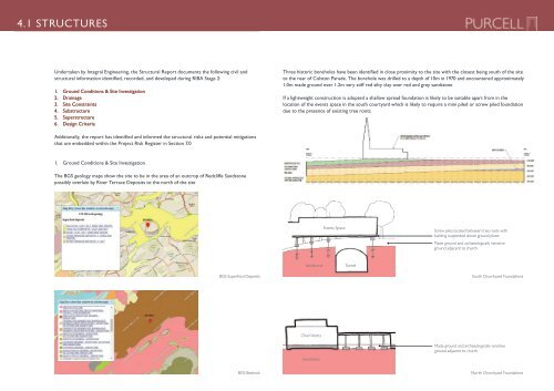
The BGS geology maps show the site to be in the area of an outcrop of <strong>Redcliffe</strong><br />
Sandstone possibly overlain by River Terrace Deposits to the north of the site.<br />
2. Ground 1. Ground Conditions Conditions & Site & Investigation<br />
The BGS geology maps show the site Site to Investigation<br />
be in the area of an outcrop of <strong>Redcliffe</strong><br />
Sandstone possibly overlain by River Terrace Deposits to the north of the site.<br />
The BGS geology maps show the site to be in the area of an outcrop of <strong>Redcliffe</strong><br />
The BGS geology maps show the site to be in the area of an outcrop of <strong>Redcliffe</strong> Sandstone<br />
Sandstone possibly overlain by River Terrace Deposits to the north of the site.<br />
possibly overlain by River Terrace Deposits to the north of the site<br />
Three historic boreholes have been identified in close proximity to the site with the closest being south of the site<br />
to the rear of Colston Parade. The borehole was drilled to a depth of 10m in 1970 and encountered approximately<br />
1.0m made ground over 1.2m very stiff red silty clay over red and grey sandstone<br />
If a lightweight construction is adopted a shallow spread foundation is likely to be suitable apart from in the<br />
location of the events space in the south courtyard which is likely to require a mini piled or screw piled foundation<br />
due to the presence of existing tree roots<br />
Figure 4. <strong>St</strong> <strong>Mary</strong> <strong>Redcliffe</strong> geology<br />
An intrusive site investigation (SI) will be required to inform the design of the proposed<br />
foundations which will need to encompass the following;<br />
Figure 2. BGS Superficial Deposits<br />
Figure 2. BGS Superficial Deposits<br />
Figure 3. BGS Bedrock<br />
Figure 3. BGS Bedrock<br />
Figure 2. BGS Superficial Deposits<br />
Figure 3. BGS Bedrock<br />
Figure 4. North churchyard foundations<br />
Figure 4. <strong>St</strong> <strong>Mary</strong> <strong>Redcliffe</strong> geology<br />
Figure 4. <strong>St</strong> <strong>Mary</strong> <strong>Redcliffe</strong> geology<br />
Three historic boreholes have been identified in close proximity to the site with the<br />
breath<br />
closest being south of the site to the rear of Colston Parade. The borehole was drilled<br />
Three historic boreholes have been identified in close proximity to the site with the<br />
to a depth of 10m in 1970 and encountered approximately 1.0m made ground over<br />
closest being south of the site to the rear of Colston Parade. The borehole was drilled<br />
1.2m very stiff red silty clay over red and grey sandstone.<br />
to a depth of 10m in 1970 and encountered approximately 1.0m made ground over<br />
If<br />
1.2m<br />
a lightweight<br />
very stiff red<br />
construction<br />
silty clay<br />
is<br />
over<br />
adopted<br />
red and<br />
a shallow<br />
grey sandstone.<br />
spread foundation is likely to be<br />
suitable apart from in the location of the events space in the south courtyard which is<br />
If a lightweight construction is adopted a shallow spread foundation is likely to be<br />
likely to require a mini piled or screw piled foundation due to the presence of existing<br />
suitable apart from in the location of the events space in the south courtyard which is<br />
tree roots.<br />
likely to require a mini piled or screw piled foundation due to the presence of existing<br />
tree roots.<br />
Made ground & burial ground<br />
Choir Vestry<br />
Made ground & burial ground<br />
Screw piles between tree<br />
Events space<br />
roots, building<br />
Screw piles between tree<br />
Events space<br />
suspended to allow trees to<br />
Sandstone roots, building<br />
Figure 5. South churchyard breath foundations<br />
suspended to allow trees to<br />
breath<br />
BGS Superficial Deposits<br />
BGS Bedrock<br />
Three historic boreholes have been identified in close proximity to the site with the<br />
closest being south of the site to the rear of Colston Parade. The borehole was drilled<br />
to a depth of 10m in 1970 and encountered approximately 1.0m made ground over<br />
1.2m very stiff red silty clay over Events red Space and grey sandstone.<br />
If a lightweight construction is adopted a shallow spread foundation is likely to be<br />
suitable apart from in the location of the events space in the south courtyard which is<br />
likely to require a mini piled or screw piled foundation due to the presence of existing<br />
tree roots.<br />
Made ground & burial ground<br />
Sandstone<br />
Events space<br />
TunnelScrew piles between tree<br />
roots, building<br />
suspended to allow trees to<br />
- 2 cable percussion boreholes with gas/water standpipes installed 1 x 10-15m<br />
borehole on the north lawn in the location of the proposed building and 1 x 15-<br />
20m in the paved area to the south of the church in area of the proposed<br />
education space.<br />
- 6-8 windowless sampler holes (small boreholes) – 3 in north area for the<br />
Screw proposed piles main located building between and basement tree roots area, 1 with under the proposed building<br />
building immediately suspended south of the above church, ground 2 under plane the proposed event space/café<br />
building, 3 - 4 of these with gas/water standpipes. (windowless sampler holes<br />
Made ground and archaeologically sensitive<br />
are small diameter boreholes drilled with a much smaller rig.)<br />
-<br />
ground<br />
3-4 hand<br />
adjacent<br />
dug pits.<br />
to<br />
On<br />
church<br />
north side where building/basement adjoins church, and<br />
An intrusive site investigation<br />
rear of the retaining<br />
(SI)<br />
wall<br />
will<br />
to<br />
be<br />
the<br />
required<br />
south of the<br />
to<br />
church<br />
inform<br />
to allow<br />
the design<br />
the existing<br />
of the prop<br />
foundations which foundations will need to to be encompass viewed. the following;<br />
An intrusive site<br />
-<br />
investigation<br />
Soakaway testing<br />
(SI)<br />
(see<br />
will<br />
section<br />
be required<br />
3.4.)<br />
to inform the design of the prop<br />
foundations which - 2 machine will need dug to trial encompass pits –one on the northern following; lawn area (for near surface<br />
- 2 cable percussion boreholes with gas/water standpipes installed 1 x 10-<br />
foundation/ground conditions) and one on the grass behind the retaining wall<br />
borehole south on the of the north church lawn (to expose in South the the location Churchyard rear of the of retaining the Foundations proposed wall and backfill) building and 1<br />
- 2 cable percussion boreholes with gas/water standpipes installed 1 x 10<br />
20m -in the <strong>St</strong>andard paved geotechnical area to the lab testing south including of the church testing for in a area piled solution, of the proposed<br />
education<br />
borehole contamination on<br />
space.<br />
the north testing lawn as appropriate in the location and targeted of the contamination proposed building testing in the and 1<br />
20m in the area paved of the old area fuel tanks to the plus south some of Waste the Acceptance church in Criteria area of testing the for proposed<br />
- 6-8 windowless<br />
education<br />
spoil<br />
space.<br />
disposal<br />
sampler<br />
characterisation<br />
holes (small boreholes) – 3 in north area for the<br />
proposed - gas/water main building monitoring and in standpipes, basement including area, monitoring 1 under for the volatile proposed vapours buildi –<br />
- 6-8 windowless sampler holes (small boreholes) – 3 in north area for the<br />
immediately minimum south of 4 of visits the church, 2 under the proposed event space/café<br />
building,<br />
proposed<br />
3<br />
main<br />
- 4 of<br />
building<br />
these with<br />
and<br />
gas/water<br />
basement<br />
standpipes.<br />
area, 1 under<br />
(windowless<br />
the proposed<br />
sampler<br />
buildi<br />
h<br />
immediately The site is archaeologically south of the sensitive church, so all 2 SI under works the will need<br />
are small diameter boreholes drilled with a much<br />
proposed to be accompanied<br />
smaller<br />
event<br />
rig.)<br />
space/café by a<br />
written scheme of investigation and an archaeological watching brief. We would also<br />
building, 3 - 4 of these with gas/water standpipes. (windowless sampler<br />
- 3-4 recommend hand dug that pits. a ground On penetrating north side radar where survey building/basement (GPR) be carried out prior adjoins to church<br />
are small diameter boreholes drilled with a much smaller rig.)<br />
rear<br />
commencement<br />
of the retaining<br />
of the intrusive<br />
wall to<br />
SI<br />
the<br />
to confirm<br />
south<br />
the<br />
of<br />
presence<br />
the church<br />
of underground<br />
to allow the existing<br />
- 3-4 obstructions. hand dug Once pits. the On results north of the side GPR where survey are building/basement available the final exploration adjoins churc<br />
foundations to be viewed.<br />
rear<br />
locations<br />
of the<br />
can<br />
retaining<br />
be agreed with<br />
wall<br />
all<br />
to<br />
parties.<br />
the south of the church to allow the existing<br />
- Soakaway testing (see section 3.4.)<br />
foundations to be viewed.<br />
- 2 The machine above Made has dug been ground trial reviewed pits and –one archaeologically by a geotechnical on the northern sensitive engineer lawn who has area provided (for near a budget surface<br />
Soakaway cost of £16,000-£20,000. testing adjacent (see Whilst to section church this is useful 3.4.) for costing purposes, we would obviously<br />
foundation/ground conditions) and one on the grass behind the retaining<br />
- 2 recommend machine that dug a trial specification pits –one be sent on to the a minimum northern of three lawn companies area (for to near provide surface a<br />
south competitive of the tender. church (to expose the rear of the retaining wall and backfill)<br />
foundation/ground conditions) and one on the grass behind the retaining<br />
- <strong>St</strong>andard geotechnical lab testing including testing for a piled solution,<br />
south of the church (to expose the rear of the retaining wall and backfill)<br />
contamination testing as appropriate and targeted contamination testing<br />
- <strong>St</strong>andard geotechnical lab testing North Churchyard including testing Foundations for a piled solution,<br />
area of the old fuel tanks plus some Waste Acceptance Criteria testing fo<br />
contamination testing as appropriate and targeted contamination testing<br />
spoil disposal characterisation<br />
area of the old fuel tanks plus some Waste Acceptance Criteria testing fo<br />
- gas/water monitoring in standpipes, including monitoring for volatile vapo